
All Village Maps India - गांव
Contains ads
100K+
Downloads

Everyone
info

About this app
All Village Maps India - गांव का नक्शा has all Indian village maps, districts of India maps, sub districts (talukas) and village maps. This village maps of India offers gaao and farm maps.
All Village Maps of India has
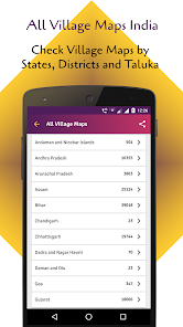
- Andaman & Nicobar Islands
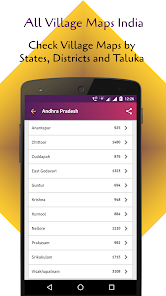
- Andhra Pradesh
- Arunachal Pradesh
- Assam
- UP Utter Pradesh Map
- MP Madhya Pradesh
- Delhi
- Maharashtra
- Gujarat
- Bihar
- Rajasthan
- Punjab
- Haryana
- West Bengal
- Chhattisgarh
- Utter Pradesh
- Chandigarh
Check All Village Maps India - गांव का नक्शा by states, district map of India. Indian village maps allows to save to my village. See state wise, districts of India, sub district and village data. You can also check village maps of India live using this app.
Application Features:
- All village maps
- Village maps
- Maps of villages
- Gram naksha
- District map
- All City map
- Map of district
- All village maps
- Village map
- Bhunaksha
- Bhu-naksha
- Panchayat naksha
How to use it:
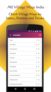
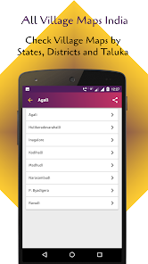
Select the state name which is given in Hindi and English, select the district which are given in the English and Regional languages. Then select Taluka (Block, Tehsil) and select the village.
If you find anything wrong or any copyright things then mail us. We would love to hear everyone.
All Village Maps of India has
- Andaman & Nicobar Islands
- Andhra Pradesh
- Arunachal Pradesh
- Assam
- UP Utter Pradesh Map
- MP Madhya Pradesh
- Delhi
- Maharashtra
- Gujarat
- Bihar
- Rajasthan
- Punjab
- Haryana
- West Bengal
- Chhattisgarh
- Utter Pradesh
- Chandigarh
Check All Village Maps India - गांव का नक्शा by states, district map of India. Indian village maps allows to save to my village. See state wise, districts of India, sub district and village data. You can also check village maps of India live using this app.
Application Features:
- All village maps
- Village maps
- Maps of villages
- Gram naksha
- District map
- All City map
- Map of district
- All village maps
- Village map
- Bhunaksha
- Bhu-naksha
- Panchayat naksha
How to use it:
Select the state name which is given in Hindi and English, select the district which are given in the English and Regional languages. Then select Taluka (Block, Tehsil) and select the village.
If you find anything wrong or any copyright things then mail us. We would love to hear everyone.
Updated on
Safety starts with understanding how developers collect and share your data. Data privacy and security practices may vary based on your use, region and age The developer provided this information and may update it over time.

No data shared with third parties
Learn more about how developers declare sharing

No data collected
Learn more about how developers declare collection

Data is encrypted in transit

Data can’t be deleted
What's new
All village, taluka, district and state maps in India. See your village's map.


