
釣りナビくん 詳細海底地図にポイント登録、GPSでボートナビ
In-app purchases
10K+
Downloads

Everyone
info
About this app
◆ What you can do with the Fishing Navi app
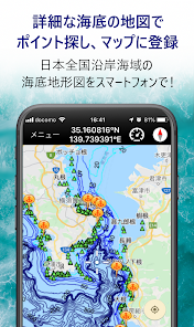
[Part 1. Display a detailed map of the seabed]
With a detailed seabed map (seabed topographic map) and the GPS function of your smartphone, you can grasp what kind of terrain the bottom of the sea where your boat is currently floating is.
It is possible to guess where the fish are lurking from the topography of the seabed, and in some sea areas, the roots and seas that are the habitats of the fish are also displayed.
* There are free and paid options depending on the map enlargement rate.
Option details: https://tsurinavi-kun.com/help/view/46/
[Part 2. Navigation function]
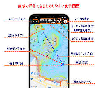
By turning on the GPS function of the smartphone, the current location is displayed on the seafloor topography map, and the direction in which you are currently moving, the orientation of the smartphone, the latitude and longitude of your current location, and the speed of the ship can be displayed. I can do it.
If you start navigating to the registered point, the direction of the point and the distance to the point will be displayed.
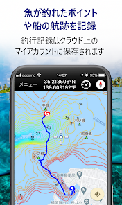
[Part 3. Register a special fishing point]
Register the points found on the map of the seabed and the secret points taught by people in My Points!
If you catch a fish in a new place, register points immediately on the spot! You can always return to the same point.
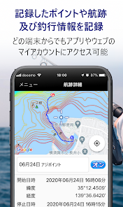
[Part 4. Record and save boat tracks]
Since you can record and save the wake of the boat, you can check the route you ran at sea and at what point you were fishing later.
In fact, the boat was swept away by the wind and was off the point! It's obvious at a glance.
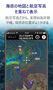
[Part 5. Display latitude / longitude and ship speed]
You can check the latitude and longitude of your current location and the latitude and longitude of your destination.
Older types of GPS fish finder, plotter, etc. may use the Japanese geodetic system to display latitude and longitude, but the coordinate position can be specified in either the world geodetic system or the Japanese geodetic system.
Boat speeds are also displayed in speeds and knots.
[Part 6. Japan national pinpoint weather information] (charged)
You can check the weather forecast and wave / wind forecasts for coastal waters all over Japan with a pinpoint of 5km square.
[Part 7. Tide table and fishing result prediction] (charged)
You can see the tide table (tide graph) of 699 places all over Japan. You can view the tide table where you are closest to you or wherever you are.
In addition, you can see the fishing result prediction "Big catch timetable PLUS" which is linked to the tide and the ebb and flow of the moon and is reputed to hit well.
Details: https://tsurinavi-kun.com/featured/view/36/
[Part 8. Linkage with website]
In addition, since Fishing Navi is linked not only with the app but also with the website, the recorded information is automatically saved in the Fishing Navi member account on the web.
If you log in to your own page on the Fishing Navi-kun website, you can view the records so far from any terminal such as a personal computer.
※ caution
When the navigation and wake recording function is used in the fishing navigation app, the location information is continuously recorded by GPS even in the background.
Therefore, it requires more power, so please be sure to bring a spare battery when you go out to sea so that your smartphone will not turn off in an emergency.
◆ What you can do on the Fishing Navi website
https://tsurinavi-kun.com
[Part 1. Edit and manage registered points and recorded tracks]
Since the Fishing Navi-kun app and the website are linked, you can edit and manage the points and wake records registered in the app on My Page of the Fishing Navi-kun PC site.
[Part 2. Sharing of fishing result information]
You can share the points and fishing results information of yourself and your fishing companions on the website.
Once you have caught a big fish, you can post it on everyone's fishing page with a photo.
[Part 3. Fishing result diary]
You can record and save your fishing record and points as your own fishing diary.
You can also save photos so you can refer to past records at any time when planning your fishing trip.
◆ Display regarding the use of seafloor topographic maps
The copyright of the seafloor topographic map used by Fishing Navi belongs to our Marine Networks under the following permission number.
Japan Coast Guard Permit No. 292503 (Similar publication based on Article 25 of the Waterway Business Law)
◆ Privacy policy
https://tsurinavi-kun.com/static/privacy/
[Part 1. Display a detailed map of the seabed]
With a detailed seabed map (seabed topographic map) and the GPS function of your smartphone, you can grasp what kind of terrain the bottom of the sea where your boat is currently floating is.
It is possible to guess where the fish are lurking from the topography of the seabed, and in some sea areas, the roots and seas that are the habitats of the fish are also displayed.
* There are free and paid options depending on the map enlargement rate.
Option details: https://tsurinavi-kun.com/help/view/46/
[Part 2. Navigation function]
By turning on the GPS function of the smartphone, the current location is displayed on the seafloor topography map, and the direction in which you are currently moving, the orientation of the smartphone, the latitude and longitude of your current location, and the speed of the ship can be displayed. I can do it.
If you start navigating to the registered point, the direction of the point and the distance to the point will be displayed.
[Part 3. Register a special fishing point]
Register the points found on the map of the seabed and the secret points taught by people in My Points!
If you catch a fish in a new place, register points immediately on the spot! You can always return to the same point.
[Part 4. Record and save boat tracks]
Since you can record and save the wake of the boat, you can check the route you ran at sea and at what point you were fishing later.
In fact, the boat was swept away by the wind and was off the point! It's obvious at a glance.
[Part 5. Display latitude / longitude and ship speed]
You can check the latitude and longitude of your current location and the latitude and longitude of your destination.
Older types of GPS fish finder, plotter, etc. may use the Japanese geodetic system to display latitude and longitude, but the coordinate position can be specified in either the world geodetic system or the Japanese geodetic system.
Boat speeds are also displayed in speeds and knots.
[Part 6. Japan national pinpoint weather information] (charged)
You can check the weather forecast and wave / wind forecasts for coastal waters all over Japan with a pinpoint of 5km square.
[Part 7. Tide table and fishing result prediction] (charged)
You can see the tide table (tide graph) of 699 places all over Japan. You can view the tide table where you are closest to you or wherever you are.
In addition, you can see the fishing result prediction "Big catch timetable PLUS" which is linked to the tide and the ebb and flow of the moon and is reputed to hit well.
Details: https://tsurinavi-kun.com/featured/view/36/
[Part 8. Linkage with website]
In addition, since Fishing Navi is linked not only with the app but also with the website, the recorded information is automatically saved in the Fishing Navi member account on the web.
If you log in to your own page on the Fishing Navi-kun website, you can view the records so far from any terminal such as a personal computer.
※ caution
When the navigation and wake recording function is used in the fishing navigation app, the location information is continuously recorded by GPS even in the background.
Therefore, it requires more power, so please be sure to bring a spare battery when you go out to sea so that your smartphone will not turn off in an emergency.
◆ What you can do on the Fishing Navi website
https://tsurinavi-kun.com
[Part 1. Edit and manage registered points and recorded tracks]
Since the Fishing Navi-kun app and the website are linked, you can edit and manage the points and wake records registered in the app on My Page of the Fishing Navi-kun PC site.
[Part 2. Sharing of fishing result information]
You can share the points and fishing results information of yourself and your fishing companions on the website.
Once you have caught a big fish, you can post it on everyone's fishing page with a photo.
[Part 3. Fishing result diary]
You can record and save your fishing record and points as your own fishing diary.
You can also save photos so you can refer to past records at any time when planning your fishing trip.
◆ Display regarding the use of seafloor topographic maps
The copyright of the seafloor topographic map used by Fishing Navi belongs to our Marine Networks under the following permission number.
Japan Coast Guard Permit No. 292503 (Similar publication based on Article 25 of the Waterway Business Law)
◆ Privacy policy
https://tsurinavi-kun.com/static/privacy/
Updated on
Safety starts with understanding how developers collect and share your data. Data privacy and security practices may vary based on your use, region, and age. The developer provided this information and may update it over time.

No data shared with third parties
Learn more about how developers declare sharing

This app may collect these data types
Location, Personal info, and App activity

Data is encrypted in transit

You can request that data be deleted
What's new
API33に対応いたしました
App support
phone
Phone number
+81353125903