
US NavCharts - FAA VFR Charts
In-app purchases


Everyone
info
10+
Downloads

Everyone
Learn more


About this app
US NavChart: Your Navigation Companion
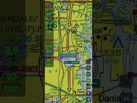
Elevate your flight experience, whether in the cockpit or the simulator. US NavChart provides high-resolution, official FAA Sectional and TAC charts directly on your Android device.
KEY FEATURES:
•
Official FAA Charts: Access up-to-date Sectional and TAC charts for the entire United States.
Simulator Integration: Connect seamlessly to Microsoft Flight Simulator (MSFS) and X-Plane via local network to mirror your sim position.
https://www.vfrdirectbr.com/download-bridge-para-fs-e-xplane
•
Real-World GPS: Use your device’s internal GPS for real-time VFR navigation and situational awareness.
•
Flight Planning: Calculate bearing (BRG), distance (DIST in NM), and estimated time of arrival (ETA) to any airport or custom waypoint.
•
Advanced HUD: Monitor your magnetic heading, altitude (FT), and ground speed (KT) with a professional, high-visibility interface.
•
Flexible Maps: Toggle between North-Up and Heading-Up modes to suit your navigation style.
BUILT FOR PILOTS & ENTHUSIASTS: Specifically designed for General Aviation (GA) pilots and flight simulation enthusiasts. Our lightweight engine ensures smooth map performance even on older devices.
SUBSCRIPTION DETAILS: Experience the full power of US NavChart with a 15-day free trial. After the trial period, a monthly subscription of only $3.00 grants you unlimited access to all premium charts and navigation features.
Navigate with US NavChart.
Elevate your flight experience, whether in the cockpit or the simulator. US NavChart provides high-resolution, official FAA Sectional and TAC charts directly on your Android device.
KEY FEATURES:
•
Official FAA Charts: Access up-to-date Sectional and TAC charts for the entire United States.
Simulator Integration: Connect seamlessly to Microsoft Flight Simulator (MSFS) and X-Plane via local network to mirror your sim position.
https://www.vfrdirectbr.com/download-bridge-para-fs-e-xplane
•
Real-World GPS: Use your device’s internal GPS for real-time VFR navigation and situational awareness.
•
Flight Planning: Calculate bearing (BRG), distance (DIST in NM), and estimated time of arrival (ETA) to any airport or custom waypoint.
•
Advanced HUD: Monitor your magnetic heading, altitude (FT), and ground speed (KT) with a professional, high-visibility interface.
•
Flexible Maps: Toggle between North-Up and Heading-Up modes to suit your navigation style.
BUILT FOR PILOTS & ENTHUSIASTS: Specifically designed for General Aviation (GA) pilots and flight simulation enthusiasts. Our lightweight engine ensures smooth map performance even on older devices.
SUBSCRIPTION DETAILS: Experience the full power of US NavChart with a 15-day free trial. After the trial period, a monthly subscription of only $3.00 grants you unlimited access to all premium charts and navigation features.
Navigate with US NavChart.
Official FAA Sectional & TAC charts with MSFS/X-Plane integration for VFR pilots
Updated on
Safety starts with understanding how developers collect and share your data. Data privacy and security practices may vary based on your use, region, and age. The developer provided this information and may update it over time.
- No data shared with third partiesLearn more about how developers declare sharing
- No data collectedLearn more about how developers declare collection


What’s new
•Official FAA Sectional & TAC charts, elevation e runways.
•MSFS & X-Plane integration.
•Advanced flight planning: set origin, destination & waypoints.
•Real-time HUD (ALT, SPD, HDG, ETA).
•Flight logging & KML export.
15-day free trial period, added a high-visibility aircraft track overlay for SEC/TAC charts, and implemented general performance optimizations. Weather Radar, ADS-B and TCAS (Requires an internet connection.)
Stable version.
•MSFS & X-Plane integration.
•Advanced flight planning: set origin, destination & waypoints.
•Real-time HUD (ALT, SPD, HDG, ETA).
•Flight logging & KML export.
15-day free trial period, added a high-visibility aircraft track overlay for SEC/TAC charts, and implemented general performance optimizations. Weather Radar, ADS-B and TCAS (Requires an internet connection.)
Stable version.
Everyone
Learn moreApp support
About the developer
TIAGO ZIR FRIEDRICHS
vfrdirectbr@gmail.com
R. Getúlio Vargas, 555 - 401
Fontes
SOLEDADE - RS
99300-000
Brazil


