World History Maps: North Amer
10+
Downloads

Everyone
info

About this app
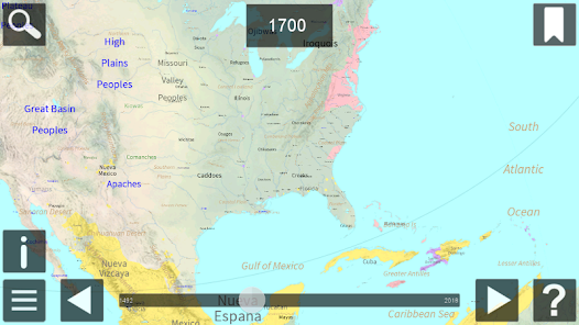
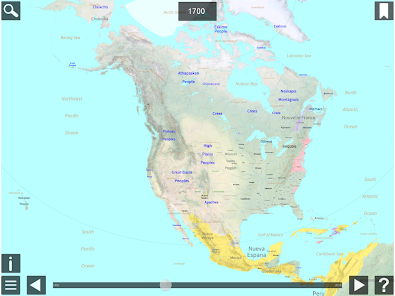
World History Maps: N America, by World History Maps Inc, is a new and unique way of looking at the history of North America. Instead of an historical atlas which has maps showing North America (or a region) at a few significant years, or maps that try to compress decades of change on to one map, we offer a different approach. Our interactive historical maps show the entire continent for every single year since 1492. This is an unprecedented amount of detail in time for North America that cannot be found anywhere else. The scalable maps allow even the smallest places to be shown. Looking at History in this detail gives one a unique perspective. These historical maps are made using GIS technology. These maps are just like our World app maps but with more details. In addition to countries, major Tribes, and Peoples at the beginning of each year, we also also show states and provinces, towns and cities, battles, parks, reservations and reservoirs, and many events including weather events. Maps are Scaleable and zoomable with popup information. Scrolling forward and backward is available with adjustable speeds. Maps can be pinned so you can toggle back and forth to compare different years. Following below are more details about how to use the app.
Updated on
Safety starts with understanding how developers collect and share your data. Data privacy and security practices may vary based on your use, region, and age. The developer provided this information and may update it over time.

No data shared with third parties
Learn more about how developers declare sharing

No data collected
Learn more about how developers declare collection
What's new
Geographic labels now render again
Labels now stay the same size when changing the year
Labels now stay the same size when changing the year