
XYZworks Triangulate
1,7star
15 ta sharh
500+
Yuklanmalar

Hamma uchun
info


Bu ilova haqida
This is useful for reporting or locating wild fires, for landowners, firefighters, land surveyors, boaters, pilots and anyone wanting to know the coordinates of a remote point without going there: Hikers, geocachers, scientific research, rangers, search and rescue, amateur radio direction finding (ARDF, transmitter hunting), location of radio tagged animals. No cell phone coverage needed! No data plan needed, except if you choose to email the info to someone.
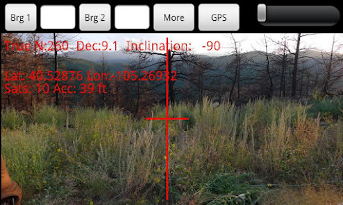
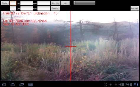
Triangulate uses your built-in GPS and compass on a camera view to get 2 points and bearings from each. It then computes the location you are pointing at. The 3 points and lines connecting them can then be displayed with your choice of mapping program (using KML files) , online or offline, for both mobile and desktop computers. This makes it easy to determine which road is best to get to the computed remote point. Here is a sample map: http://maps.google.com/maps/ms?ie=UTF&msa=0&msid=208093473308607160239.0004b82ddcc76689ba82a"
I saw a real use for this app to save lives, property, and nature since I almost died when my 2 houses burned down in a wildfire. Firefighters took hours to determine where the fire was located and how to get there, because the calls to 911 were not giving enough info.
Optimized for phones and tablets.
Phone reception or Internet access is not required to use the app. Designed so you can have someone call, radio, or email to report their GPS coordinates and their compass bearing for the 2nd point. If the other person has the Triangulate app they can easily hit 1 button to collect, and 1 button to email their location and bearing. 1 point and bearing is enough info to report a wildfire to 911, but if you get another bearing from >1000 feet (~300m) away its even better since the app can compute a location for the remote point.
Firefighters who have this app can easily take the data from multiple reports, even enter data from those who don't have this app, using an old fashioned compass or handheld GPS, to locate the fire much easier and less error prone than the old method of getting out paper maps, compass, and plotting the positions and drawing lines to find the intersection.
Designed for international use: distances in feet or meters.
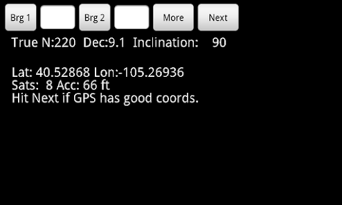
Displays your GPS coordinates, number of satellites in view, and the accuracy of your position. Automatically computes the declination at your location to use True North (more accurate) compass bearings. You can use an old fashioned compass and enter the bearings.
It has an option to choose between using the camera sight for the compass (default), or sight across the face of the phone to get better accuracy for phones where you have a small camera or poor visibility.
Here is a link to the help instructions included in the app, to see more details about how it works:
http://www.xyzworks.com/triangulateHelp.htm
You can repeat and get bearings from more than 2 points and view them as overlays on a map too. That's why it saves the data as KML files so you can save as many bearings as you like and view them on the phone or desktop machine using many map programs, or email them to view with a bigger screen on desktop google maps.
See XYZworks entire line of land surveying, data collection, and construction software at:
www.xyzworks.com
Triangulate uses your built-in GPS and compass on a camera view to get 2 points and bearings from each. It then computes the location you are pointing at. The 3 points and lines connecting them can then be displayed with your choice of mapping program (using KML files) , online or offline, for both mobile and desktop computers. This makes it easy to determine which road is best to get to the computed remote point. Here is a sample map: http://maps.google.com/maps/ms?ie=UTF&msa=0&msid=208093473308607160239.0004b82ddcc76689ba82a"
I saw a real use for this app to save lives, property, and nature since I almost died when my 2 houses burned down in a wildfire. Firefighters took hours to determine where the fire was located and how to get there, because the calls to 911 were not giving enough info.
Optimized for phones and tablets.
Phone reception or Internet access is not required to use the app. Designed so you can have someone call, radio, or email to report their GPS coordinates and their compass bearing for the 2nd point. If the other person has the Triangulate app they can easily hit 1 button to collect, and 1 button to email their location and bearing. 1 point and bearing is enough info to report a wildfire to 911, but if you get another bearing from >1000 feet (~300m) away its even better since the app can compute a location for the remote point.
Firefighters who have this app can easily take the data from multiple reports, even enter data from those who don't have this app, using an old fashioned compass or handheld GPS, to locate the fire much easier and less error prone than the old method of getting out paper maps, compass, and plotting the positions and drawing lines to find the intersection.
Designed for international use: distances in feet or meters.
Displays your GPS coordinates, number of satellites in view, and the accuracy of your position. Automatically computes the declination at your location to use True North (more accurate) compass bearings. You can use an old fashioned compass and enter the bearings.
It has an option to choose between using the camera sight for the compass (default), or sight across the face of the phone to get better accuracy for phones where you have a small camera or poor visibility.
Here is a link to the help instructions included in the app, to see more details about how it works:
http://www.xyzworks.com/triangulateHelp.htm
You can repeat and get bearings from more than 2 points and view them as overlays on a map too. That's why it saves the data as KML files so you can save as many bearings as you like and view them on the phone or desktop machine using many map programs, or email them to view with a bigger screen on desktop google maps.
See XYZworks entire line of land surveying, data collection, and construction software at:
www.xyzworks.com
Oxirgi yangilanish
Xavfsizlik — dastur ishlab chiquvchilar maʼlumotlaringizni qanday jamlashi va ulashishini tushinishdan boshlanadi. Maʼlumotlar maxfiyligi va xavfsizlik amaliyotlari ilovadan foydalanish, hudud va yoshga qarab farq qilishi mumkin. Bu axborot dastur ishlab chiquvchi tomonidan taqdim etilgan va keyinchalik yangilanishi mumkin.


Reytinglar va sharhlar
1,7
13 ta sharh
Nima yangiliklar
1.03 Added a menu option to turn off sound since some phones have trouble playing a sound.
1.04 Fixed a bug causing a force close after hitting the More button on some phones.
1.05 Improved it for some countries to work around an android bug so it shows a decimal point instead of a comma in the lat, lon and KML.
1.06 Improved so it doesn't flash a compass unreliable message on some phones.