
スマホ山ナビ
100+
Downloads

Everyone
info

About this app
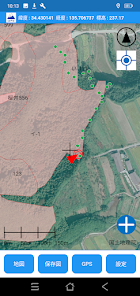
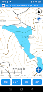
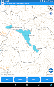
・Maps that can be displayed are the Geospatial Information Authority of Japan standard and aerial photographs.
・Process cadastral maps and forest plan maps into KMZ files that can be displayed with this app on a computer.
・On the display screen, the above KMZ file data (division map, point data) can be displayed overlaid on the map.
・Up to 9999 points of point data can be recorded and transferred to a PC as a GPX file.
・Up to 9999 points (approximately 80 hours) of trajectory (track) data can be recorded and transferred to a PC as a GPX file.
・Save the map in memory as an offline map in order to display the map in places where radio waves are not connected.
Updated on
Safety starts with understanding how developers collect and share your data. Data privacy and security practices may vary based on your use, region, and age. The developer provided this information and may update it over time.

This app may share these data types with third parties
Personal info and Device or other IDs

No data collected
Learn more about how developers declare collection

Data is encrypted in transit