
Mgrs & Utm Map Pro
4.8star
1.82K reviews
10K+
Downloads

Everyone
info


About this app
Special features at pro version:
👉 More maps (Bicycle, Topographic, Neighborhood, Atlas etc.)
👉 You can see the altitude profile of your route on the chart
👉 You can search for locations by address
👉 You can create different layers for your different activities
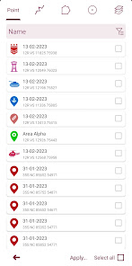
👉 List view for markers, routes, areas and KML
👉 You can draw multiple routes and areas, and change their colors
👉 More and colorful pointer icons
👉 Name or icon display options for markers
👉 Multiple routes can be recorded with the GPS recorder
👉 And no ads
This application is GPS and coordinate systems helper especially for military personnel.
It is also a complete helper for mountaineering, trekking and hiking, cross running, scouting, hunting, fishing, geocaching, off-road navigation and all other outdoor activities and sports.
With satellite navigation systems such as GPS, GALILEO and GLONASS (GNSS) supported by your device and your sensors, you can see your most accurate position on different map layers.
Features:
* Easy and Faster
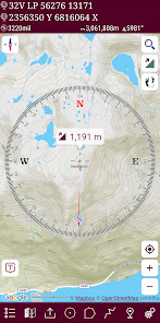
* Compass.
=> Compass on map (on the map that shows your direction)
=> Compass only (shows physical directions)
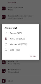
=> Angular units for compass (degrees, grad and mil)
* Follow Mode
=> The center of the map follows your location while on the move.
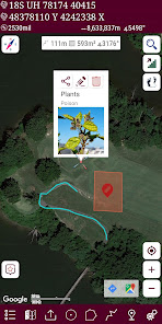
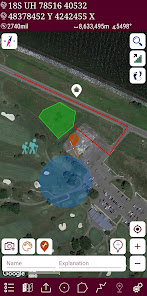
* You can add and removing markers.
* Distance measure. (You can add custom route and calculate total distance)
* Area measure.(You can select an area on the map and calculate the area in square meters)
* You can see the altitude of your location.
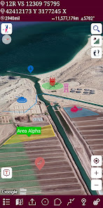
* You can find the location according to Address, Degree/Minute/Second , MGRS, UTM or Latitude/Longitude formats.
* Location (Coordinate) unit options.
=> MGRS / U.S. National Grid (USNG) (WGS84/NAD83)
=> D°M'S" (WGS84)
=> Latitude/Longitude (WGS84)
=> UTM (WGS84/NAD83)
=> SK42(Gauss Kruger)
=> British National Grid(OSNG)
=> Irish Grid Reference
=> ED50
=> ITRF
* Map type options (Road,Terrain,Satellite,Night Mode,Hybrid)
* You can share location coordinate.
* Distance unit options. (meter and feet).
* KML viewer. (Export and import KML layers).
👉 More maps (Bicycle, Topographic, Neighborhood, Atlas etc.)
👉 You can see the altitude profile of your route on the chart
👉 You can search for locations by address
👉 You can create different layers for your different activities
👉 List view for markers, routes, areas and KML
👉 You can draw multiple routes and areas, and change their colors
👉 More and colorful pointer icons
👉 Name or icon display options for markers
👉 Multiple routes can be recorded with the GPS recorder
👉 And no ads
This application is GPS and coordinate systems helper especially for military personnel.
It is also a complete helper for mountaineering, trekking and hiking, cross running, scouting, hunting, fishing, geocaching, off-road navigation and all other outdoor activities and sports.
With satellite navigation systems such as GPS, GALILEO and GLONASS (GNSS) supported by your device and your sensors, you can see your most accurate position on different map layers.
Features:
* Easy and Faster
* Compass.
=> Compass on map (on the map that shows your direction)
=> Compass only (shows physical directions)
=> Angular units for compass (degrees, grad and mil)
* Follow Mode
=> The center of the map follows your location while on the move.
* You can add and removing markers.
* Distance measure. (You can add custom route and calculate total distance)
* Area measure.(You can select an area on the map and calculate the area in square meters)
* You can see the altitude of your location.
* You can find the location according to Address, Degree/Minute/Second , MGRS, UTM or Latitude/Longitude formats.
* Location (Coordinate) unit options.
=> MGRS / U.S. National Grid (USNG) (WGS84/NAD83)
=> D°M'S" (WGS84)
=> Latitude/Longitude (WGS84)
=> UTM (WGS84/NAD83)
=> SK42(Gauss Kruger)
=> British National Grid(OSNG)
=> Irish Grid Reference
=> ED50
=> ITRF
* Map type options (Road,Terrain,Satellite,Night Mode,Hybrid)
* You can share location coordinate.
* Distance unit options. (meter and feet).
* KML viewer. (Export and import KML layers).
Updated on
Safety starts with understanding how developers collect and share your data. Data privacy and security practices may vary based on your use, region, and age. The developer provided this information and may update it over time.


Ratings and reviews
4.8
1.74K reviews

Daniel Stanford
- Flag inappropriate
September 13, 2022
ALMOST THERE Please for the love of God add Layers. This app is SUPER helpful and I have recommended it to other SMs aswell. However, when planning a FTX with multiple points and areas of interest it becomes very crowded. This can be avoided by adding layers that you can hide, bring forward or merge. I will continue utilizing this amazing app and I can't wait to see what else you do with it!
15 people found this review helpful
DakikTech
September 13, 2022
Hi Daniel , This feature is already available. Go to the list menu from the lower left button. You can add different layers with the + button at the bottom. If what you want is different, please send me an e-mail explaining.

Dimitri Ivanov
- Flag inappropriate
February 19, 2023
Great map app for people who prefer MGRS One feature I'm still waiting for: Please give us the option to copy MGRS coordinates to the clipboard without the spaces. All the spaces need to be deleted manually for sharing locations with others: other map apps and search engines can interpret MGRS coordinates, so it's a great way to share a location; but this doesn't work with the spaces; many programs don't ignore them as they should.
4 people found this review helpful

A Google user
- Flag inappropriate
- Show review history
April 9, 2019
Awesome route overlay ability. 1. The route and marker icons aren't showing up when I turn them on and off after a route was emailed to me from a friend and then opened in the app. I have to click each route icon individually. 2. Add grid lines for map usage. 3. Make actual military map icons to utilize for different overlays.
15 people found this review helpful
DakikTech
April 9, 2019
Hi anthony. I will continue to develop. Thanks for feedbacks
App support
phone
Phone number
+905413857349
About the developer
Zahid Çataltaş
zhdctlts@gmail.com
İstiklal mahallesi, 1170 sokak, no:18, daire 6, Pamukkale , Denizli
Cinkaya Yapı 1
20000 Ege/Denizli
Türkiye
undefined


