
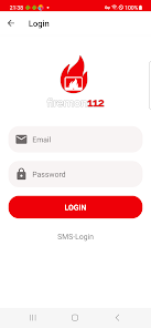
Firemon 112 App

5.0star
5 reviewsinfo
500+
Downloads

USK: All ages
info


About this app
Volunteer developed and operated open source mission preparation and administration, by comrades for comrades!
Works with:
Raspberry Pi 3 & 4 (e.g. as a garden shed monitor)
Windows 10 app (e.g. as a device shed monitor)
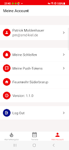
Android and iPhone (as a web app, e.g. for executives)
Any Internet-enabled device (e.g. Chrome, Firefox or Edge)
purpose
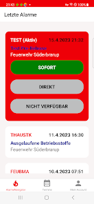
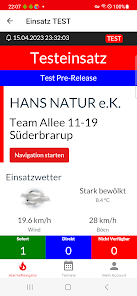
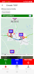
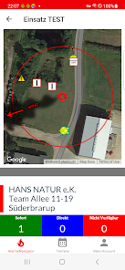
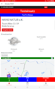
Firemon 112 is primarily aimed at local and community fire departments. It processes deployment dispatches sent from the control center (currently KRLS North & KRLS West, others possible!) based on its own technology and infrastructure, in compliance with data protection regulations and in real time. The dispatch dispatches received are enriched with valuable tactical information and distributed and displayed on enabled devices (garden monitors, tablets, cell phones).
In detail, the visualization includes the display of:
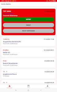
Key word and location
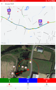
Location and object plan
co-alert forces
Approach route with traffic situation
Bird's-eye view of the deployment object with wind vane
Fire hydrant locations
staging areas
Incoming Forces (Deployment Feedback)
The visualization can take place in parallel on other devices. On request, all tactically valuable information including approach route and bird's eye view as well as other useful information (e.g. danger matrix) can be printed out directly (if a printer is available). A special feature is the way the route is planned: this is not based on the transmitted address, but on the basis of the much more precise UTM coordinates from the alarm message. These are first converted into geographic degrees of longitude and latitude and then used as a definition for the location. Special traffic situations, road closures, etc. can be taken into account here.
In the event of an alarm, Firemon 112 can inform emergency services in a loop-controlled manner via:
SMS
voice call
e-mail
Divera Free
further alarm methods are in progress...
Firemon 112 can be easily integrated into the training service with the ability to trigger training alerts directly or by time.
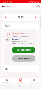
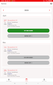
Firemon 112 is also able to manage appointments and events. With the help of the reminder function, you can be reminded of practice evenings by e-mail, for example, and accept or cancel them with a click. The list of participants can be viewed live at any time in the protected area.
The Firemon 112 software will be made available to all interested fire services free of charge on request. Of course, you have to procure the hardware yourself - you can find self-assembly instructions with a list of materials here. To cover the running costs for server, backup, weather data, etc., an annual fee of €50 per weir is charged. Firemon 112 is non-profit forever and is being developed by comrades for comrades!
Works with:
Raspberry Pi 3 & 4 (e.g. as a garden shed monitor)
Windows 10 app (e.g. as a device shed monitor)
Android and iPhone (as a web app, e.g. for executives)
Any Internet-enabled device (e.g. Chrome, Firefox or Edge)
purpose
Firemon 112 is primarily aimed at local and community fire departments. It processes deployment dispatches sent from the control center (currently KRLS North & KRLS West, others possible!) based on its own technology and infrastructure, in compliance with data protection regulations and in real time. The dispatch dispatches received are enriched with valuable tactical information and distributed and displayed on enabled devices (garden monitors, tablets, cell phones).
In detail, the visualization includes the display of:
Key word and location
Location and object plan
co-alert forces
Approach route with traffic situation
Bird's-eye view of the deployment object with wind vane
Fire hydrant locations
staging areas
Incoming Forces (Deployment Feedback)
The visualization can take place in parallel on other devices. On request, all tactically valuable information including approach route and bird's eye view as well as other useful information (e.g. danger matrix) can be printed out directly (if a printer is available). A special feature is the way the route is planned: this is not based on the transmitted address, but on the basis of the much more precise UTM coordinates from the alarm message. These are first converted into geographic degrees of longitude and latitude and then used as a definition for the location. Special traffic situations, road closures, etc. can be taken into account here.
In the event of an alarm, Firemon 112 can inform emergency services in a loop-controlled manner via:
SMS
voice call
Divera Free
further alarm methods are in progress...
Firemon 112 can be easily integrated into the training service with the ability to trigger training alerts directly or by time.
Firemon 112 is also able to manage appointments and events. With the help of the reminder function, you can be reminded of practice evenings by e-mail, for example, and accept or cancel them with a click. The list of participants can be viewed live at any time in the protected area.
The Firemon 112 software will be made available to all interested fire services free of charge on request. Of course, you have to procure the hardware yourself - you can find self-assembly instructions with a list of materials here. To cover the running costs for server, backup, weather data, etc., an annual fee of €50 per weir is charged. Firemon 112 is non-profit forever and is being developed by comrades for comrades!
Updated on
Safety starts with understanding how developers collect and share your data. Data privacy and security practices may vary based on your use, region, and age. The developer provided this information and may update it over time.


What's new
- Integration neues Gruppensystem
- Unterstützung von Zweitmitgliedschaften
- Library Updates
- Bugfixes
- Unterstützung von Zweitmitgliedschaften
- Library Updates
- Bugfixes