
Estonian Drone Map
50+
Downloads

Everyone
info

About this app
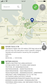
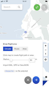
Estonian Drone Map is the official UTM solution from Estonian Air Navigation Services. The application allows you to see the rules for flying in Estonia, plan your flights and coordinate them with the air navigation service provider, if necessary.
The current app version:
• Displays all the temporary and permanent restriction areas, including UAS geozones and NOTAM's
• Allows the pilot to plan their flights and submit flight plans (not mandatory for open category flights)
• Ask the ANSP for mandatory take-off clearance near helicopter pads and for specific category flights
Updated on
Safety starts with understanding how developers collect and share your data. Data privacy and security practices may vary based on your use, region, and age. The developer provided this information and may update it over time.

No data shared with third parties
Learn more about how developers declare sharing

This app may collect these data types
Personal info, Messages and 2 others

Data is encrypted in transit

You can request that data be deleted
What's new
First release of Estonian Drone Map