
Alice Springs offline map
10+
Downloads

Everyone
info
About this app
Offline map of Alice Springs and Uluru/Ayers Rock, Australia with the southern half of the Northern Territory for tourist & business visitors. Download before you go and avoid expensive roaming charges. The map runs completely on your device; display with pan and zoom, routing, search, bookmark, everything. It does not use your data connection at all. Switch your phone function off if you want to!
No ads. All features fully functional on installation, you do not need to buy add-ons or do extra downloads.
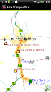
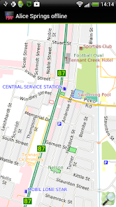
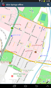
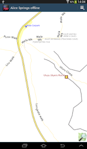
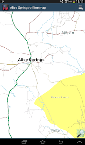
The map includes the entire city, Ayers Rock, Uluru, and the complete southern half of the Northern Territory up to Tennant Creek on the Stuart Highway. You can show a route to any place for motor vehicle, foot or bicycle; even without a GPS device.
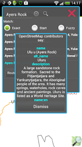
The map is based on OpenStreetMap data, http://www.openstreetmap.org.
How good is it? The Alice Spring road network appears to be complete with names. Uluru is mapped in detail. Places to stay and things to do and see seem well covered. Coverage of eating places, shops, pharmacies, banks etc is patchy. You can help improve it by becoming an OpenStreetMap contributor. We periodically publish free updates with the latest data.
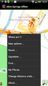
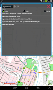
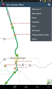
The app includes a search function and a gazetteer of commonly needed items like hotels, eating places, shops, things to see and do, golf courses.
You can bookmark places like your hotel for easy return navigation using "My Places".
Turn-by-turn navigation is available. If you don't have a GPS device, you can still show a route between two locations.
Navigation will show you an indicative route and can be configured for car, bicycle or foot. The developers provide it without any guarantee that it is always correct. For example, it does not show turn restrictions - places where it is illegal to turn. Use with care and above all look out for and obey road signs.
Like most small developers, we cannot test a wide variety of phones and tablets. If you have trouble running the application, do email us and we will try to help.
No ads. All features fully functional on installation, you do not need to buy add-ons or do extra downloads.
The map includes the entire city, Ayers Rock, Uluru, and the complete southern half of the Northern Territory up to Tennant Creek on the Stuart Highway. You can show a route to any place for motor vehicle, foot or bicycle; even without a GPS device.
The map is based on OpenStreetMap data, http://www.openstreetmap.org.
How good is it? The Alice Spring road network appears to be complete with names. Uluru is mapped in detail. Places to stay and things to do and see seem well covered. Coverage of eating places, shops, pharmacies, banks etc is patchy. You can help improve it by becoming an OpenStreetMap contributor. We periodically publish free updates with the latest data.
The app includes a search function and a gazetteer of commonly needed items like hotels, eating places, shops, things to see and do, golf courses.
You can bookmark places like your hotel for easy return navigation using "My Places".
Turn-by-turn navigation is available. If you don't have a GPS device, you can still show a route between two locations.
Navigation will show you an indicative route and can be configured for car, bicycle or foot. The developers provide it without any guarantee that it is always correct. For example, it does not show turn restrictions - places where it is illegal to turn. Use with care and above all look out for and obey road signs.
Like most small developers, we cannot test a wide variety of phones and tablets. If you have trouble running the application, do email us and we will try to help.
Updated on
Safety starts with understanding how developers collect and share your data. Data privacy and security practices may vary based on your use, region, and age. The developer provided this information and may update it over time.

No data shared with third parties
Learn more about how developers declare sharing

This app may collect these data types
App activity, App info and performance, and Device or other IDs

Data is encrypted in transit
What's new
- Latest OpenStreetMap data
- Android 10 compatibility
- Removed "Advanced Find" menu item to simplify the app, contact us via our Developer Email on the Google Play Store if you want this back.
- Added Crashlytics. If the app crashes, information about the crash is automatically sent to us. No personal data is sent. Your location is not sent.
- Ski runs and ski lifts now show where applicable
- Reservoir dams now show
- Some map style tweaks, e.g service roads thinner to contrast them better.
App support
About the developer
Michael John Collinson
mike@ayeltd.biz
Rialavägen 62
186 97 Brottby
Sweden
undefined


