
Brisbane offline map
50+
Downloads

Everyone
info
About this app
Offline map of Brisbane, Queensland, Australia and surrounding areas for business and tourist visitors. Download before you go or using your hotel's Wi-Fi and avoid expensive roaming charges. The map runs completely on your device; map, routing, search, bookmark, everything.
It does not use your data connection at all. Switch your phone function off if you want to!
No ads. All features fully functional, no extra downloads, no "in store purchases" required.
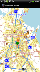
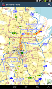
The map includes Brisbane's airports and extends to Redcliffe in the north, Logan City in the south, and Ipswich in the west. Places include Deception Bay, Inala, Kallangur, Murrumba Dows, Narangba, Nudgee Beach Redbank, Rochedale, Springfield Lakes, Strathpine.
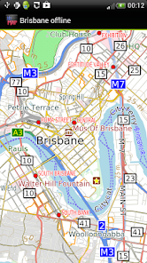
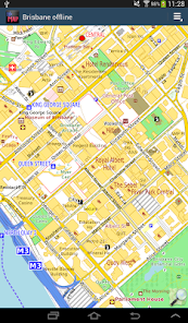
The map is based on OpenStreetMap data, http://www.openstreetmap.org. It includes all the main roads and most if not all urban roads with street names. Coverage of rural areas roads is reasonable but may not be 100%. Amenities such as hotels, eating places, banks is reasonable but still evolving. You can help improve it by becoming an OpenStreetMap contributor. We publish periodic free updates with the latest data.
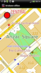
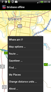
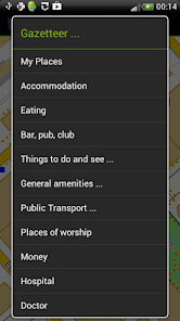
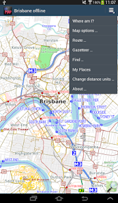
The app includes a search function and a gazetteer of commonly needed items like hotels, eating places and pharmacies as well as museums and other things to see and do.
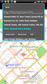
You can bookmark places like your hotel for easy return navigation.
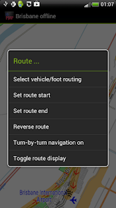
Simple turn-by-turn navigation is available. If you don't have a GPS device, you can still show a route between two locations.
Navigation will show you an indicative route and can be configured for car, bicycle or foot. The developers provide it without any guarantee that it is always correct. For example, OpenStreetMap does not always have turn restrictions - places where it is illegal to turn. Some rural roads may be suitable for four-wheel drive vehicles only and/or for people familiar with the area and terrain. Some rural roads may be impassable during wet weather. Use with care and above all look out for and obey road signs.
It does not use your data connection at all. Switch your phone function off if you want to!
No ads. All features fully functional, no extra downloads, no "in store purchases" required.
The map includes Brisbane's airports and extends to Redcliffe in the north, Logan City in the south, and Ipswich in the west. Places include Deception Bay, Inala, Kallangur, Murrumba Dows, Narangba, Nudgee Beach Redbank, Rochedale, Springfield Lakes, Strathpine.
The map is based on OpenStreetMap data, http://www.openstreetmap.org. It includes all the main roads and most if not all urban roads with street names. Coverage of rural areas roads is reasonable but may not be 100%. Amenities such as hotels, eating places, banks is reasonable but still evolving. You can help improve it by becoming an OpenStreetMap contributor. We publish periodic free updates with the latest data.
The app includes a search function and a gazetteer of commonly needed items like hotels, eating places and pharmacies as well as museums and other things to see and do.
You can bookmark places like your hotel for easy return navigation.
Simple turn-by-turn navigation is available. If you don't have a GPS device, you can still show a route between two locations.
Navigation will show you an indicative route and can be configured for car, bicycle or foot. The developers provide it without any guarantee that it is always correct. For example, OpenStreetMap does not always have turn restrictions - places where it is illegal to turn. Some rural roads may be suitable for four-wheel drive vehicles only and/or for people familiar with the area and terrain. Some rural roads may be impassable during wet weather. Use with care and above all look out for and obey road signs.
Updated on
Safety starts with understanding how developers collect and share your data. Data privacy and security practices may vary based on your use, region, and age. The developer provided this information and may update it over time.

No data shared with third parties
Learn more about how developers declare sharing

This app may collect these data types
App activity, App info and performance, and Device or other IDs

Data is encrypted in transit

Data can’t be deleted
What's new
- Latest OpenStreetMap data
- Android 10 compatibility
- Removed "Advanced Find" menu item to simplify the app, contact us via our Developer Email on the Google Play Store if you want this back.
- Added Crashlytics. If the app crashes, information about the crash is automatically sent to us. No personal data is sent. Your location is not sent.
- Ski runs and ski lifts now show where applicable
- Reservoir dams now show
- Some map style tweaks, e.g service roads thinner to contrast them better.


