

Everyone
info
500+
Downloads

Everyone
Learn more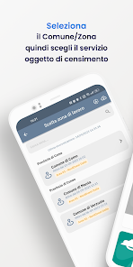

About this app
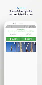
Li.PAD ® MOBILE MAPPING - THE APP FOR GPS SURVEYING
Li.PAD ® APP Mobile Mapping is the leading solution in Italy in the survey and timely census of technological networks, particularly in the public lighting sector with almost 3,000,000 lighting points registered in almost 2,000 Italian municipalities (including Genoa, Savona, La Spezia, Vicenza, Livorno, Pavia, Parma, Pisa, Campobasso, Bari, Brindisi, Matera, Potenza, ...).
Li.PAD ® Mobile Mapping was born in 2015 from the need of companies in the energy sector to equip themselves with a user friendly tool for the field survey of light points, electrical panels and network elements for the purposes of drafting the State of Fact of the system of Public Lighting, or as a certain and punctual starting point for maintenance operations which can be scheduled by the personnel in charge, following a report from the citizen or on their own initiative.
The operator will have the Li.PAD ® ENERGY Mobile Mapping APP available through which he will be able to manage in detail the operations planned in the ODL or himself choose the interventions necessary for the regular closure of the maintenance action.
Taking advantage of dozens of specific creations implemented over the last few years on the Smart City theme, a modular extension to the census platform was set up during the first half of 2023 which groups together the functions of:
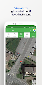
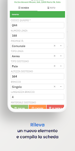
• survey of the state of fact with technical data sheets and photographic repertoire,
• design, creation and posting of QR Code plates,
• reporting of inefficiencies by citizens via app, web and call centre,
• ordinary operational maintenance.
- CHARACTERISTICS -
Easy to use
The use of a device such as a smartphone makes mapping work extremely simple and intuitive, even on a bicycle.
Low hardware costs
The combination of smartphone and autonomous GPS receiver (optional) limits the setup of the work equipment to a few tens of euros.
Dedicated features
The development of the procedure in close contact with companies active in the energy sector allows for the timely scheduling of technical characteristics.
Export DXF, XLSX, ...
25 years of developing cartographic applications allow us to communicate with the most popular GIS and technical software such as QGIS, AutoCAD and ArcGIS.
- SPIN OFF -
The high degree of customization of the service has made it possible to prepare various solutions for surveying in the field or from a fixed station and the subsequent management of information on personal sites:
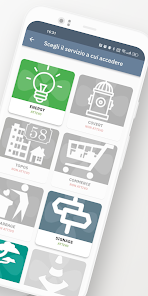
Li.PAD ® Energy – Public lighting, traffic light systems, ...
Li.PAD ® Garbage - MSW collection, bins and ecological islands
Li.PAD ® Covert - Technological networks, manholes and network elements
Li.PAD ® Green - Public green areas, vegetative state monitoring
Li.PAD ® Signage - Road signs and/or posters
Li.PAD ® Rainbow - Public roads, instabilities and damage from bad weather
Li.PAD ® Topos - Toponymy, house numbering.
Li.PAD ® Outdoor – Trails, points of interest, information signs
Li.PAD ® Indoor - Planimetric survey for energy diagnosis, maintenance reporting, inventory (electrical, heating, air conditioning, fire prevention, video surveillance, medical equipment, doors and windows)
Li.PAD ® APP Mobile Mapping is the leading solution in Italy in the survey and timely census of technological networks, particularly in the public lighting sector with almost 3,000,000 lighting points registered in almost 2,000 Italian municipalities (including Genoa, Savona, La Spezia, Vicenza, Livorno, Pavia, Parma, Pisa, Campobasso, Bari, Brindisi, Matera, Potenza, ...).
Li.PAD ® Mobile Mapping was born in 2015 from the need of companies in the energy sector to equip themselves with a user friendly tool for the field survey of light points, electrical panels and network elements for the purposes of drafting the State of Fact of the system of Public Lighting, or as a certain and punctual starting point for maintenance operations which can be scheduled by the personnel in charge, following a report from the citizen or on their own initiative.
The operator will have the Li.PAD ® ENERGY Mobile Mapping APP available through which he will be able to manage in detail the operations planned in the ODL or himself choose the interventions necessary for the regular closure of the maintenance action.
Taking advantage of dozens of specific creations implemented over the last few years on the Smart City theme, a modular extension to the census platform was set up during the first half of 2023 which groups together the functions of:
• survey of the state of fact with technical data sheets and photographic repertoire,
• design, creation and posting of QR Code plates,
• reporting of inefficiencies by citizens via app, web and call centre,
• ordinary operational maintenance.
- CHARACTERISTICS -
Easy to use
The use of a device such as a smartphone makes mapping work extremely simple and intuitive, even on a bicycle.
Low hardware costs
The combination of smartphone and autonomous GPS receiver (optional) limits the setup of the work equipment to a few tens of euros.
Dedicated features
The development of the procedure in close contact with companies active in the energy sector allows for the timely scheduling of technical characteristics.
Export DXF, XLSX, ...
25 years of developing cartographic applications allow us to communicate with the most popular GIS and technical software such as QGIS, AutoCAD and ArcGIS.
- SPIN OFF -
The high degree of customization of the service has made it possible to prepare various solutions for surveying in the field or from a fixed station and the subsequent management of information on personal sites:
Li.PAD ® Energy – Public lighting, traffic light systems, ...
Li.PAD ® Garbage - MSW collection, bins and ecological islands
Li.PAD ® Covert - Technological networks, manholes and network elements
Li.PAD ® Green - Public green areas, vegetative state monitoring
Li.PAD ® Signage - Road signs and/or posters
Li.PAD ® Rainbow - Public roads, instabilities and damage from bad weather
Li.PAD ® Topos - Toponymy, house numbering.
Li.PAD ® Outdoor – Trails, points of interest, information signs
Li.PAD ® Indoor - Planimetric survey for energy diagnosis, maintenance reporting, inventory (electrical, heating, air conditioning, fire prevention, video surveillance, medical equipment, doors and windows)
Updated on
Safety starts with understanding how developers collect and share your data. Data privacy and security practices may vary based on your use, region, and age. The developer provided this information and may update it over time.

No data shared with third parties
Learn more about how developers declare sharing

This app may collect these data types
Location, Photos and videos and 3 others

Data isn’t encrypted
Data can’t be deleted
What’s new
- bug fix e miglioramenti vari
Everyone
Learn moreApp support
phone
Phone number
+39017588428
About the developer
LEONARDO WEB SRL
contatti@leonardoweb.eu
VIA GALIMBERTI 50
12030 MANTA
Italy
+39 0175 88428


