
Radroutenplaner Hessen
50K+
Downloads

Everyone
info

About this app
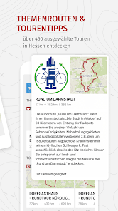
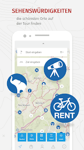
Be inspired by over 450 selected tours in Hesse or plan your individual bike tour. With the help of the address search or by setting route points on the map, you can easily plan bike tours throughout Hesse. The tour can be planned even better using the route details for length and duration and the elevation profile. Find out about sights along the way, locations of rental bikes, charging stations for e-bikes and much more. The services reporting platform for cycling and the school cycle route planner can also be used via the mobile application.
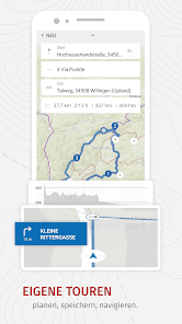
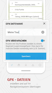
The navigation of the Hessen cycle route planner guides you along the planned route. If necessary, the routes can also be transferred to your own navigation system by downloading the associated GPX tracks.
Anyone who prefers to plan their tour at home on their PC or laptop can simply transfer the planned route to the app. Simply take a picture of the QR code displayed in the web application with your mobile phone camera. The planned route is then opened in the app and can be edited there or used for navigation.
Updated on
Safety starts with understanding how developers collect and share your data. Data privacy and security practices may vary based on your use, region, and age. The developer provided this information and may update it over time.


What's new
Dieses Update enthält Verbesserungen und Fehlerbehebungen:
- Luftbilder als Kartenhintergrund (werden vor Veröffentlichung noch auf RRPH Gebiet zugeschnitten)
- Integration von Kreisverkehren in der Navigation
- Sprachausgabe in der Navigation
- Optimierung der Navigationsanweisungen bei Richtungsänderungen (ab 35° Richtungsänderung)
- Darstellung von Schiebestrecken
- Darstellung von gefährlichen Abschnitten im Schülerrouting