
Lumi Marine
Contains ads
10+
Downloads

Everyone
info
About this app
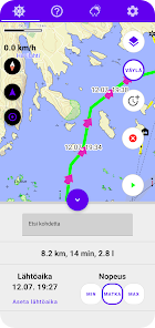
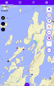
The application provides route planning and weather forecasts for coastal and inland boaters. You can search for boat routes along waterways or plan them by freely combining waypoints.
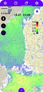
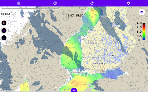
The free version has a twelve-hour wind map, water height from tide gauges, weather observations, wave buoys and point-like weather forecasts. The Majakka subscription also includes lightning observations, wind warnings for the searched route and a 58-hour wind map. The weather information comes from the Meteorological Institutes of Finland, Sweden and Estonia.
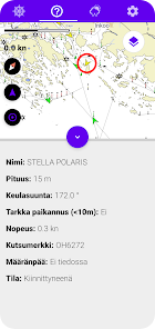
The lighthouse subscription also includes other useful features for the boater, such as the AIS layer of the map, the ship's bearing, an estimate of fuel consumption, a search for water bodies and an adjustable route deviation warning.
The maps of the application are based on the materials of the Land Surveying Institute and the Finnish Railways Agency. Maps based on Traficom's marine chart materials are also coming to the application as an additional subscription.
The application alone does not guarantee safe navigation and it does not replace a printed nautical chart.
The free version has a twelve-hour wind map, water height from tide gauges, weather observations, wave buoys and point-like weather forecasts. The Majakka subscription also includes lightning observations, wind warnings for the searched route and a 58-hour wind map. The weather information comes from the Meteorological Institutes of Finland, Sweden and Estonia.
The lighthouse subscription also includes other useful features for the boater, such as the AIS layer of the map, the ship's bearing, an estimate of fuel consumption, a search for water bodies and an adjustable route deviation warning.
The maps of the application are based on the materials of the Land Surveying Institute and the Finnish Railways Agency. Maps based on Traficom's marine chart materials are also coming to the application as an additional subscription.
The application alone does not guarantee safe navigation and it does not replace a printed nautical chart.
Updated on
Safety starts with understanding how developers collect and share your data. Data privacy and security practices may vary based on your use, region, and age. The developer provided this information and may update it over time.

No data shared with third parties
Learn more about how developers declare sharing

This app may collect these data types
Device or other IDs

Data isn’t encrypted
Data can’t be deleted