Vikazimut
10K+
Downloads

Everyone
info
About this app
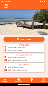
Vikazimut is a project of students from the National Engineering School ENSICAEN which aims to facilitate the practice of orienteering sports. The application replaces the map, the compass and the control card and displays a retrospective analysis of the route taken.
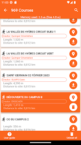
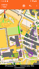
The orienteer uses the application to find the way using the map and validates the passage at the checkpoints manually with the QR code or NFC readers or automatically with the GPS position. At the end of the course, the application displays some statistics: the total time, the split times and the track on the map.
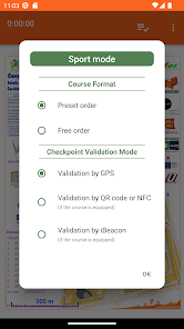
Vikazimut comes in two modes. A sport mode where the orienteer is not helped for his position and a walk mode where the orienteer is positioned on the map in real time. In walk mode, some routes display cultural information at checkpoint.
The orienteer uses the application to find the way using the map and validates the passage at the checkpoints manually with the QR code or NFC readers or automatically with the GPS position. At the end of the course, the application displays some statistics: the total time, the split times and the track on the map.
Vikazimut comes in two modes. A sport mode where the orienteer is not helped for his position and a walk mode where the orienteer is positioned on the map in real time. In walk mode, some routes display cultural information at checkpoint.
Updated on
Safety starts with understanding how developers collect and share your data. Data privacy and security practices may vary based on your use, region, and age. The developer provided this information and may update it over time.


What's new
Fixed a bug related to GPS track capture
Reviewed Rogaine mode
Fixed bug on course downloading
Reviewed Rogaine mode
Fixed bug on course downloading