
Cantal Rando & Découverte
5K+
Downloads

Everyone
info
About this app
Welcome to Cantal! You are in a mecca for hiking, outdoor activities and heritage. The Cantal Rando & Découverte application makes it possible to select routes and activities, to hike in complete safety, to identify the natural and cultural points of interest to discover on your route and to locate useful services nearby.
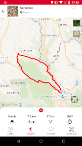
A functional application: real-time geolocation, IGN base map, offline mapping, geo-notification, route tracking.
A varied range of activities and routes: hiking, cycling, mountain biking, VAE, horseback, looping, roaming; places and leisure facilities in the great outdoors ...
With Cantal Rando & Découverte, it's easy to:
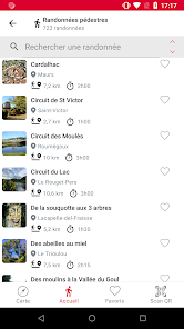
-Prepare your outings: geolocation (know your position to determine the starting point of your activity), visualization (choose your hike according to the level of difficulty or the number of kilometers desired), description (take note of the atmosphere you go find out);
-Take advantage of its activities: travel time (real-time tracking, visualization of the route and the percentage of progress), accessible services and points of interest (tracking relative to your position), geonotification (information on points of interest when you pass nearby).
Cantal Rando & Découverte is the app for all your outings in Cantal.
A functional application: real-time geolocation, IGN base map, offline mapping, geo-notification, route tracking.
A varied range of activities and routes: hiking, cycling, mountain biking, VAE, horseback, looping, roaming; places and leisure facilities in the great outdoors ...
With Cantal Rando & Découverte, it's easy to:
-Prepare your outings: geolocation (know your position to determine the starting point of your activity), visualization (choose your hike according to the level of difficulty or the number of kilometers desired), description (take note of the atmosphere you go find out);
-Take advantage of its activities: travel time (real-time tracking, visualization of the route and the percentage of progress), accessible services and points of interest (tracking relative to your position), geonotification (information on points of interest when you pass nearby).
Cantal Rando & Découverte is the app for all your outings in Cantal.
Updated on
Safety starts with understanding how developers collect and share your data. Data privacy and security practices may vary based on your use, region, and age. The developer provided this information and may update it over time.

No data shared with third parties
Learn more about how developers declare sharing

This app may collect these data types
Personal info and App info and performance

Data is encrypted in transit


