
5K+
Downloads

Everyone
info


About this app
This application is intended for light aircraft or gliders pilots.
It provides navigation aid and moving map on android 4.1+ devices.
Caution :
- VFR runs much better on a device with fast storage and 2GB or more RAM.
- Licence policy requires, at least once a month, an internet connection when starting VFR to renew a full month period of disconnected use.
- NOT FOR OPERATIONAL USE ! VFR cannot and should not replace any legal flight planning and navigation documents inboard your aicraft.
Features :
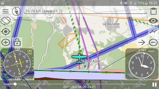
* Shows GPS position on a moving map. Choose data source from :
- Google Maps in plan, satellite or terrain mode (only available with an internet connection).
- Embeded (available even without internet connection) from OpenStreetMap data, freely downloadable in 2 levels of details.
* GPS track recording in KML file format.
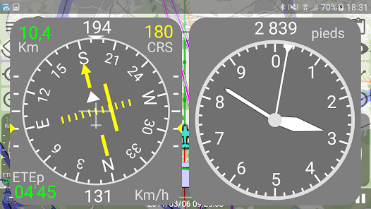
* Speed gauge (km/h or knots), heading and alt gauges (meters or feet, APMS ou AGL) and many other gauges in text or needle mode.
* Screen layout customization for gauges.
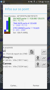
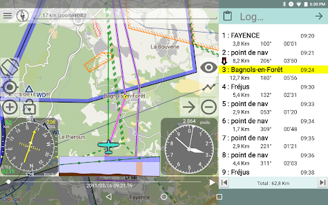
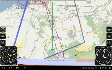
* Displays controlled, restricted or prohibited zones, ADs with runways and report points, VOR, TACAN, NDB on the moving map.
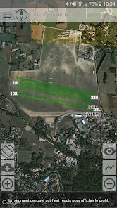
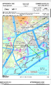
* Access on VAC charts simply by tapping en AD on the map.
* Many countries VAC charts are available for free download on the data section.
* Some VAC charts are geolocated and can be displayed on the moving map (With Android 5+)
* Shows vertical profile of the ground and zones ahead the plane trajectory with 5 minutes projection of the current course (with a point at each minute).
* Allows route preparation by adding points one by one on the map and enter altitude and speed settings for each.
* GPX routes import.
* Immediate goto airport mode.
* Search in data for AD, report point, locations etc...
* Shows drifting from planned route (alt, speed and course).
* Shows estimed time to next point or arrival (ETE, ETA).
* Automatic route point switching when approaching current route point.
* Navigation log display.
* ... more on http://www.odonati.fr (currently in french but soon in english too)
It provides navigation aid and moving map on android 4.1+ devices.
Caution :
- VFR runs much better on a device with fast storage and 2GB or more RAM.
- Licence policy requires, at least once a month, an internet connection when starting VFR to renew a full month period of disconnected use.
- NOT FOR OPERATIONAL USE ! VFR cannot and should not replace any legal flight planning and navigation documents inboard your aicraft.
Features :
* Shows GPS position on a moving map. Choose data source from :
- Google Maps in plan, satellite or terrain mode (only available with an internet connection).
- Embeded (available even without internet connection) from OpenStreetMap data, freely downloadable in 2 levels of details.
* GPS track recording in KML file format.
* Speed gauge (km/h or knots), heading and alt gauges (meters or feet, APMS ou AGL) and many other gauges in text or needle mode.
* Screen layout customization for gauges.
* Displays controlled, restricted or prohibited zones, ADs with runways and report points, VOR, TACAN, NDB on the moving map.
* Access on VAC charts simply by tapping en AD on the map.
* Many countries VAC charts are available for free download on the data section.
* Some VAC charts are geolocated and can be displayed on the moving map (With Android 5+)
* Shows vertical profile of the ground and zones ahead the plane trajectory with 5 minutes projection of the current course (with a point at each minute).
* Allows route preparation by adding points one by one on the map and enter altitude and speed settings for each.
* GPX routes import.
* Immediate goto airport mode.
* Search in data for AD, report point, locations etc...
* Shows drifting from planned route (alt, speed and course).
* Shows estimed time to next point or arrival (ETE, ETA).
* Automatic route point switching when approaching current route point.
* Navigation log display.
* ... more on http://www.odonati.fr (currently in french but soon in english too)
Updated on
Safety starts with understanding how developers collect and share your data. Data privacy and security practices may vary based on your use, region, and age. The developer provided this information and may update it over time.

No data shared with third parties
Learn more about how developers declare sharing

No data collected
Learn more about how developers declare collection
What's new
Fix crash when downloading data on Android 14