BIOS Kappler Tal
100+
Downloads

Everyone
info


About this app
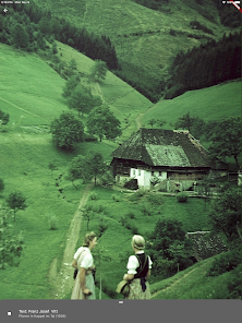
The Kappler Valley is a district of the city of Freiburg and extends from the Dreisamtal (338m altitude) to the Schauinsland summit (1284m altitude). It belongs to the Black Forest biosphere area, which has been a UNESCO natural heritage site since 2017.
In this context, the project "Man - Time - Earth, Thematic Trail Habitat Freiburg-Kappel" funded by the Black Forest Biosphere Reserve was conceived in 2019/20.
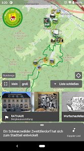
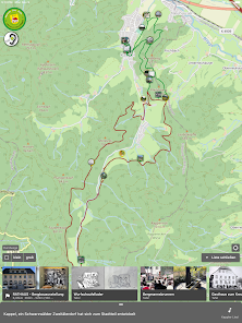
In cooperation between the Art and Culture Association Freiburg-Kappel eV, the Freiburg-Kappel local administration and the city of Freiburg, two circular routes were created that take visitors to various stations in the front Kappl Valley (small circular route 6.95 km) and in the rear Kappler Valley ( large circular route 12.8km).
The stations consist of:
19 information boards + mining exhibition
Using descriptions, pictures and spoken stories, they give an insight into the Kappl Valley, its culture and its eventful history - with a special focus on the mining era.
12 soundscapes (soundscapes)
The acoustic signature of a landscape contains a multitude of information about the respective ecosystem - not only about the occurrence of different animal species, but also about its structural composition, the degree of human influence, seasonal and daily rhythms and climatic interrelationships. For this purpose, 47 sound recordings with sounds and noises of various kinds and associated explanations are available.
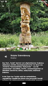
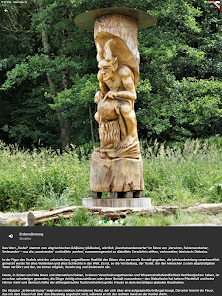
7 sculptures
Human striving, life, seduction, hope, search, connections, globalization and dealing with our world - old topics that have not lost their relevance in the 21st century are taken up and interpreted in seven large-format wooden sculptures.
The BIOS Kappler Tal app accompanies you through the themed trail. It includes an interactive map that shows the two circular routes and their various stations, thus enabling independent navigation through the area. The information and pictures on the information boards and the related stories can be accessed via the app. The soundscapes with sound samples as well as additional information and images are also stored in the app. The app also provides background images, text and sound for the seven sculptures.
All stations are listed in the app and can either be run using GPS or selected manually.
In this context, the project "Man - Time - Earth, Thematic Trail Habitat Freiburg-Kappel" funded by the Black Forest Biosphere Reserve was conceived in 2019/20.
In cooperation between the Art and Culture Association Freiburg-Kappel eV, the Freiburg-Kappel local administration and the city of Freiburg, two circular routes were created that take visitors to various stations in the front Kappl Valley (small circular route 6.95 km) and in the rear Kappler Valley ( large circular route 12.8km).
The stations consist of:
19 information boards + mining exhibition
Using descriptions, pictures and spoken stories, they give an insight into the Kappl Valley, its culture and its eventful history - with a special focus on the mining era.
12 soundscapes (soundscapes)
The acoustic signature of a landscape contains a multitude of information about the respective ecosystem - not only about the occurrence of different animal species, but also about its structural composition, the degree of human influence, seasonal and daily rhythms and climatic interrelationships. For this purpose, 47 sound recordings with sounds and noises of various kinds and associated explanations are available.
7 sculptures
Human striving, life, seduction, hope, search, connections, globalization and dealing with our world - old topics that have not lost their relevance in the 21st century are taken up and interpreted in seven large-format wooden sculptures.
The BIOS Kappler Tal app accompanies you through the themed trail. It includes an interactive map that shows the two circular routes and their various stations, thus enabling independent navigation through the area. The information and pictures on the information boards and the related stories can be accessed via the app. The soundscapes with sound samples as well as additional information and images are also stored in the app. The app also provides background images, text and sound for the seven sculptures.
All stations are listed in the app and can either be run using GPS or selected manually.
Updated on
Safety starts with understanding how developers collect and share your data. Data privacy and security practices may vary based on your use, region, and age. The developer provided this information and may update it over time.

No data shared with third parties
Learn more about how developers declare sharing

No data collected
Learn more about how developers declare collection