Nautical Info Service Croatia
3.0star
427 reviews
Government
info
50K+
Downloads

Everyone
info
About this app
Nautical Information Service (nIS) is a free multilingual application for smartphones, intended for owners of yachts and boats, fishermen, divers, swimmers and other people who spend time on the coast and at sea. nIS was developed so that users could provide substantial and detailed information to the local harbormaster’s offices and other services for navigation safety, prevention of marine pollution, and especially to search and rescue services, in a quick and simple way. nIS can also provide users all the necessary information important for their safety, at any time and at every place.
nIS enables users to dial a phone number used for distress, urgency or safety calls - 195 (MRCC Rijeka), while automatically reporting location of the caller via a short text message (SMS), which essentially reduces the time needed to find users in danger.
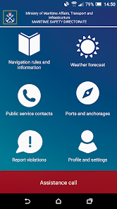
Contents of the nIS application:
• phone call to the toll-free number of the search and rescue service – 195, with information on current location
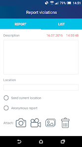
• maritime violation report (with an option to attach photos and/or videos)
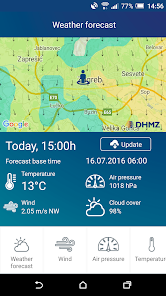
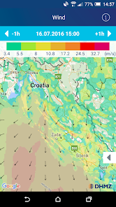
• weather forecast for mariners (air temperature, wind speed and direction, air pressure, waves, cloud cover)
• navigation rules (vessel equipment, order in ports and at sea, avoiding collision at sea, marine environment protection, information for foreign vessels, divers and swimmers, radio service and radio notices, maritime marks)
• public services contacts (search and rescue, harbormaster's offices, hyperbaric chamber, commercial salvage, consulates, medical institutions, emergency services, VTS service, coastal radio stations)
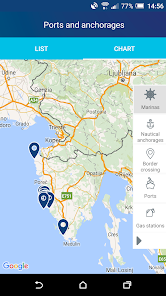
• ports and anchorages (marines, nautical anchorages, petrol stations, border crossings)
nIS enables users to dial a phone number used for distress, urgency or safety calls - 195 (MRCC Rijeka), while automatically reporting location of the caller via a short text message (SMS), which essentially reduces the time needed to find users in danger.
Contents of the nIS application:
• phone call to the toll-free number of the search and rescue service – 195, with information on current location
• maritime violation report (with an option to attach photos and/or videos)
• weather forecast for mariners (air temperature, wind speed and direction, air pressure, waves, cloud cover)
• navigation rules (vessel equipment, order in ports and at sea, avoiding collision at sea, marine environment protection, information for foreign vessels, divers and swimmers, radio service and radio notices, maritime marks)
• public services contacts (search and rescue, harbormaster's offices, hyperbaric chamber, commercial salvage, consulates, medical institutions, emergency services, VTS service, coastal radio stations)
• ports and anchorages (marines, nautical anchorages, petrol stations, border crossings)
Updated on
Safety starts with understanding how developers collect and share your data. Data privacy and security practices may vary based on your use, region, and age. The developer provided this information and may update it over time.


Ratings and reviews
3.0
417 reviews

Csaba Simon
- Flag inappropriate
September 28, 2024
As a nautical app I'd prefer the windspeed in kts(knots) instead of m/s. I cannot see option in settings to change it. BTW, is the wind map valid for gusts or just average wind speed?

Danijel Kurinčič
- Flag inappropriate
August 8, 2020
This app wants half of possible permissions on the phone for no stated reason, then requires registration with a number of personal data for no stated reason and ... When you still say "mkay, i want it badly", it crashes after registration and then crashes on every app open attempt. How bad is this? Did you actually try to use this aop after you made it?
4 people found this review helpful
Ministarstvo pomorstva, prometa i infrastrukture
August 10, 2020
We are sorry for the inconvenience, we've just released a version which should be available soon with the issue fixed.

Igor Novak
- Flag inappropriate
August 22, 2020
Anchorage charts are not reliable. South Adiratic region is missing a lot of places, for example, infront of Dubrovnik, areas around Pakleni islands in front of Borovac island. Great idea for and app but still needs a lot of work.
1 person found this review helpful
What's new
Small UI tweaks and stability fixes.
App support
About the developer
MINISTARSTVO MORA, PROMETA I INFRASTRUKTURE
Krunoslav.Rendulic@mmpi.hr
Prisavlje 14
10000, Zagreb
Croatia
+385 99 538 2178