Hydroinfo
10K+
Downloads

Everyone
info


About this app
National Water Level Service operates within the framework of the National Water Authority (OVF) (OVSZ) prepare for each day of the year the water level forecasts for major domestic vízmércéire streams and contribute to the current wading information. The water level forecasts for the production takes into account current and expected evolution of the meteorological situation, and to carry out major rivers basins of domestic sections of ice forecasts and the Danube main heat accumulation calculation is winter.
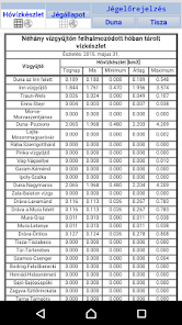
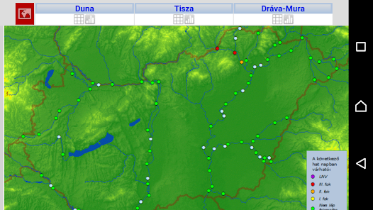
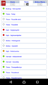
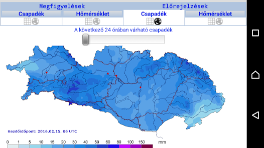
The results of the calculations for HYDROINFO trading application available product of wealth finds text, tabular, graphical and map formats. Quickly offers the latest Danube, Tisza, Drava forecasts, meteorological background information or even sub-basins of the accumulated amount of snow on the Danube catchment area.
HYDROINFO Extras:
- Hydroinfo Monitor: Find out right away to the latest projections, use the Monitor. Only the Tisza forecasts are interested? You can set what you want to be notified according to your needs.
- My Hydroinfo: A GPS can help you look at the nearest water gauge predicted positions!
- Favorite Hydroinfo: Choose your favorite vízmércét! So you can save time and avoid it all the time having to get its vízmércét you are interested in a long list.
Updated on
Safety starts with understanding how developers collect and share your data. Data privacy and security practices may vary based on your use, region, and age. The developer provided this information and may update it over time.

No data shared with third parties
Learn more about how developers declare sharing

No data collected
Learn more about how developers declare collection
What’s new
Android 13.0 kompatibilitás
App support
About the developer
Dr. Liptay Zoltán Árpád
ovsz@vizugy.hu
Hungary