
Israel Hiking Map
In-app purchases
4.7star
258 reviews
100K+
Downloads

Everyone
info

About this app
Israel Hiking Map is a powerful, yet simple to use, navigation and route-planning tool for the outdoors.
Geared towards hikers, bikers and off-road drivers it keeps you oriented in the Israeli backcountry even with no cellular reception. Use crisp topographic maps to navigate, familiarize with nearby points of interest, plan, import and share routes, synchronize effortlessly with our trip-planning site and much more.
Here’s what you get for free:
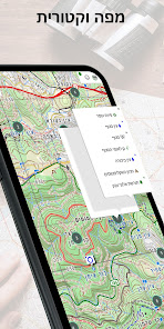
Maps
- Vector maps with unlimited zoom with no loss of quality
- A hiking map, complete with blazed trails.
- A biking map, compete with single tracks marked for difficulty and marked bike routes.
- Hebrew and English versions of all maps
- Text labels that orient to the viewers’ perspective
- A satellite image
- Transparent map overlays to show topography and trails over the sat image
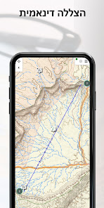
Depth perception
- High resolution contour lines based on spatial data from NASA
- Dynamic hill-shading which changes as the map rotates for accurate
depth perception at a glance
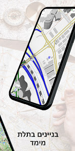
- 3D models of many buildings in urban areas
Navigation
- Show your position and direction
- Orient the map north or in your direction of movement
- Record your path as you travel
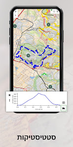
- Analyze your speed and distance traveled
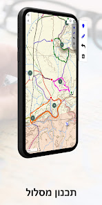
Routes
- Search for nearby routes for walking, driving and biking
- Plan your own routes – they would automatically follow the roads and paths on the map
- Manipulate routes – reverse, split or merge them at will
- Handle several routes at once
- Effortlessly synchronize with the routes you plan on our website
- Share routes or save them on your phone
- Analyze the height profile of routes
Points of interest
- An extensive list of historical sites, tourist attractions, campsites, springs and viewpoints to visit
- Easy access to geo-located articles from Wikipedia and iNature
- Easily add your own POIs to the map
Offline map purchase
You can buy a yearly subscription to our offline maps. Use them when you are out of reception or want to save your battery. The maps are continuously updated.
Geared towards hikers, bikers and off-road drivers it keeps you oriented in the Israeli backcountry even with no cellular reception. Use crisp topographic maps to navigate, familiarize with nearby points of interest, plan, import and share routes, synchronize effortlessly with our trip-planning site and much more.
Here’s what you get for free:
Maps
- Vector maps with unlimited zoom with no loss of quality
- A hiking map, complete with blazed trails.
- A biking map, compete with single tracks marked for difficulty and marked bike routes.
- Hebrew and English versions of all maps
- Text labels that orient to the viewers’ perspective
- A satellite image
- Transparent map overlays to show topography and trails over the sat image
Depth perception
- High resolution contour lines based on spatial data from NASA
- Dynamic hill-shading which changes as the map rotates for accurate
depth perception at a glance
- 3D models of many buildings in urban areas
Navigation
- Show your position and direction
- Orient the map north or in your direction of movement
- Record your path as you travel
- Analyze your speed and distance traveled
Routes
- Search for nearby routes for walking, driving and biking
- Plan your own routes – they would automatically follow the roads and paths on the map
- Manipulate routes – reverse, split or merge them at will
- Handle several routes at once
- Effortlessly synchronize with the routes you plan on our website
- Share routes or save them on your phone
- Analyze the height profile of routes
Points of interest
- An extensive list of historical sites, tourist attractions, campsites, springs and viewpoints to visit
- Easy access to geo-located articles from Wikipedia and iNature
- Easily add your own POIs to the map
Offline map purchase
You can buy a yearly subscription to our offline maps. Use them when you are out of reception or want to save your battery. The maps are continuously updated.
Updated on
Safety starts with understanding how developers collect and share your data. Data privacy and security practices may vary based on your use, region, and age. The developer provided this information and may update it over time.


Ratings and reviews
4.7
251 reviews

Baruch Youssin
- Flag inappropriate
May 2, 2024
A good app with offline maps that include hiking and biking trails; can be used without internet connection, locating you on the map. Requires a modern phone and over 1 GB storage for the maps. With no in-app help, not always clear messages given by the app and not always smooth interface, developers respond promptly to messages via Report an issue in the menu; my experience was within a day. Give it a few days (better a week) to download the maps and get it working, as it may take >1 message.
Israel Hiking
May 4, 2024
Sorry that you feel this way. The app gave you ample guidance and notifications that was ignored, as we have shown you in a detailed e-mail. The FAQ link on the "about" menu provides training and help. Using a standard reliable internet connection, the download of the offline maps takes a few minutes - much faster that the standard raster maps.

MIA
- Flag inappropriate
April 4, 2024
Incredible app. Was a pleasure to plan a trip in the Golan heights. Took a while to figure out which button did what but excellent none the less. 10/10

Nick Levi
- Flag inappropriate
May 8, 2021
Excelent hiking app. The developers demonstrate care about the user, replying to comments and mails. The app itself is very useful, helping to navigate trails, showing places of interest along the way. It has the added benefit of enabling user editing, which allows real-time updating of conditions at specific sites. Good stuff!
10 people found this review helpful
Israel Hiking
May 8, 2021
Thank you very much your kind words and the 5-star review!!!
This kind of feedback encourages us to continue and provide the best app and support we can!
What's new
The major changes in this version are:
- Improve login failure handling
- Improve UI in layers and English main menu
- Various bug fixes
The full list can be found at https://github.com/IsraelHikingMap/Site/milestone/72?closed=1
- Improve login failure handling
- Improve UI in layers and English main menu
- Various bug fixes
The full list can be found at https://github.com/IsraelHikingMap/Site/milestone/72?closed=1