
Sentieri Appennino

Everyone
info
50K+
Downloads

Everyone
Learn more


About this app
This App is dedicated to all mountain enthusiasts and hikers of the Tuscan-Emilian Apennines.
It offers a series of maps and guides, downloadable for free, which integrate to form a continuous map of the territory.
The territories currently covered include the area from Reggio Emilia and part of Piacenza, from the Apuan Alps to the Mantua area
Other areas are under development and will be published soon
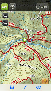
The App allows you to see your position on the maps thanks to the GPS integrated into the smartphone and allows you to record the trace of the route taken.
It also allows you to store personalized notes, to locate your points of interest on the map such as springs, botanical emergencies, mushroom farms.
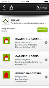
In the App, refuges, bivouacs and other information of interest to the hiker are listed and positioned, with the relevant information.
It works off-line, i.e. without the need for connection to the telephone network or internet. This guarantees its full use even in the total absence of a signal and without any additional costs for telephone traffic.
The App allows you to record tracks even with the screen off, so in this recording mode, and only in this recording mode, prolonged use of GPS in the background can drastically reduce battery life.
It offers a series of maps and guides, downloadable for free, which integrate to form a continuous map of the territory.
The territories currently covered include the area from Reggio Emilia and part of Piacenza, from the Apuan Alps to the Mantua area
Other areas are under development and will be published soon
The App allows you to see your position on the maps thanks to the GPS integrated into the smartphone and allows you to record the trace of the route taken.
It also allows you to store personalized notes, to locate your points of interest on the map such as springs, botanical emergencies, mushroom farms.
In the App, refuges, bivouacs and other information of interest to the hiker are listed and positioned, with the relevant information.
It works off-line, i.e. without the need for connection to the telephone network or internet. This guarantees its full use even in the total absence of a signal and without any additional costs for telephone traffic.
The App allows you to record tracks even with the screen off, so in this recording mode, and only in this recording mode, prolonged use of GPS in the background can drastically reduce battery life.
Updated on
Safety starts with understanding how developers collect and share your data. Data privacy and security practices may vary based on your use, region, and age. The developer provided this information and may update it over time.

No data shared with third parties
Learn more about how developers declare sharing

No data collected
Learn more about how developers declare collection
Everyone
Learn moreApp support
About the developer
Danilo Cavalli
danilo@geomedia.re.it
Via Domenico Marchelli, 1
42123 Reggio nell'Emilia
Italy


