
Via Francisca del Lucomagno
1K+
Downloads

Everyone
info
About this app
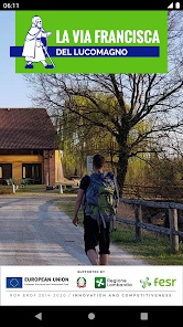
The Via Francisca del Lucomagno is an ancient itinerary that connected central Europe with Rome. The starting point is Costanza, and after crossing Switzerland, the route enters Italy at Lavena Ponte Tresa. From there, in 135 km, you reach Pavia, crossing point with the Via Francigena.
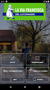
The App "La Via Francisca del Lucomagno" allows easy orientation along the three routes: walking, cycling and hand-bike.
The interactive map allows you to view your position on the route using the GPS of the device, even without internet connection: you can dowload the maps avoiding data usage.
In case of distraction, an alarm will warn you if you move away from the route, and you can report any problems on the routes by communicating your GPS position.
Reception facilities, services and points of interest along the routes are located on the map, and you can contact them directly from your smartphone.
In the individual stages are listed in order of distance all the places where there are useful services for pilgrims, such as: fountains, bars, restaurants, reception facilities and pharmacies.
In the "info" section you will find the contact details to find credentials and any useful contacts.
Buon Cammino!
The Application "La Via Francisca del Lucomagno" is a project realized within the "Actions - AXIS III of POR FESR 2014-2020".
Updated on
Safety starts with understanding how developers collect and share your data. Data privacy and security practices may vary based on your use, region, and age. The developer provided this information and may update it over time.

No data shared with third parties
Learn more about how developers declare sharing

No data collected
Learn more about how developers declare collection

Data is encrypted in transit

Data can’t be deleted
What's new
Minor bugfixes


