
IN.TER.PA Fleet Management
10+
Downloads

Everyone
info

About this app
With this mobile App you simplify and optimize the use of the municipal school bus service. You can monitor the route taken by the vehicle in real time and know the travel times. To avoid unnecessary waiting at stops, push notifications will alert you about any delays or breakdowns.
Simple and intuitive use
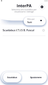
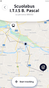
Once the application is launched, after the welcome screen, you will see in the "favorites" list the identification of the school bus of your interest from which you can receive information on the route taken. On the map, after activating "start tracking", you will be able to view the real time route of the chosen school bus and, subsequently, all the information relating to the vehicle and travel times.
Precise and immediate information
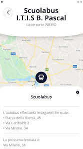
The application allows you to know, in advance, the arrival time of the school bus at the stop closest to your home and the consequent arrival time at the final destination (school). You will avoid long and unnecessary waiting at the stops, which are particularly uncomfortable on days with adverse weather conditions. The system also generates useful information on the reverse path. You will be able to know the exact departure time of the school bus from the stop located near the school and, consequently, with the same precision the arrival time at the stop closest to your home.
The system is part of IN.TER.PA
The study and operation of the mobile App are part of IN.TER.PA, a complex interregional E-Government project that allows the digitization of administrative processes and the dissemination of digital services to citizens, businesses and local authorities.
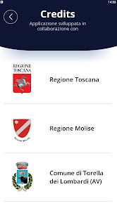
The project sees the collaboration between the Tuscany Region (leader), the Campania Region and the Molise Region, as well as the involvement of the Municipality of Torella dei Lombardi (AV), representing the Union of Municipalities of Alta Irpinia. The Municipality of Mirabello Sannitico in the province of Campobasso also joined the project. From the reuse of the I.TER platform. of the Campania Region, IN.TER.PA is developed with specific verticalizations: from the advanced WEB-GIS platforms and for the management of cartography and the generation of advanced reports, to the simplified procedures for the acquisition and homogenization of the data transmitted by the Municipalities aimed at drafting of Regional Plans and Programs. From the dissemination of Geo-Community modules, to Mobile Apps that allow geo-referenced data to be conveyed directly to the competent offices of the interested Bodies in order to offer digitized services with high added value to citizens and businesses.
The Network is created and funded as part of the National Operational Governance and Institutional Capacity Program 2014-2020 - FSE / FESR and the PA 2020 Open Community Notice with the contribution of the digital partner AlmavivA Spa.
Simple and intuitive use
Once the application is launched, after the welcome screen, you will see in the "favorites" list the identification of the school bus of your interest from which you can receive information on the route taken. On the map, after activating "start tracking", you will be able to view the real time route of the chosen school bus and, subsequently, all the information relating to the vehicle and travel times.
Precise and immediate information
The application allows you to know, in advance, the arrival time of the school bus at the stop closest to your home and the consequent arrival time at the final destination (school). You will avoid long and unnecessary waiting at the stops, which are particularly uncomfortable on days with adverse weather conditions. The system also generates useful information on the reverse path. You will be able to know the exact departure time of the school bus from the stop located near the school and, consequently, with the same precision the arrival time at the stop closest to your home.
The system is part of IN.TER.PA
The study and operation of the mobile App are part of IN.TER.PA, a complex interregional E-Government project that allows the digitization of administrative processes and the dissemination of digital services to citizens, businesses and local authorities.
The project sees the collaboration between the Tuscany Region (leader), the Campania Region and the Molise Region, as well as the involvement of the Municipality of Torella dei Lombardi (AV), representing the Union of Municipalities of Alta Irpinia. The Municipality of Mirabello Sannitico in the province of Campobasso also joined the project. From the reuse of the I.TER platform. of the Campania Region, IN.TER.PA is developed with specific verticalizations: from the advanced WEB-GIS platforms and for the management of cartography and the generation of advanced reports, to the simplified procedures for the acquisition and homogenization of the data transmitted by the Municipalities aimed at drafting of Regional Plans and Programs. From the dissemination of Geo-Community modules, to Mobile Apps that allow geo-referenced data to be conveyed directly to the competent offices of the interested Bodies in order to offer digitized services with high added value to citizens and businesses.
The Network is created and funded as part of the National Operational Governance and Institutional Capacity Program 2014-2020 - FSE / FESR and the PA 2020 Open Community Notice with the contribution of the digital partner AlmavivA Spa.
Updated on
Safety starts with understanding how developers collect and share your data. Data privacy and security practices may vary based on your use, region, and age. The developer provided this information and may update it over time.

No data shared with third parties
Learn more about how developers declare sharing

No data collected
Learn more about how developers declare collection
What's new
correzione di errori


