

FIELD-TERRACE

10K+
Downloads

Everyone
info
About this app
In addition to conventional surveying work such as surveying (pile driving/reverse driving/positioning/marking) and observation (coordinate/vertical/cross-sectional verification) at construction sites, 3D design data can be used to set stakes at arbitrary positions. It is possible to check the difference between design and actual measurement at any position of TIN or structure, regardless of installation or center alignment.
In addition, for structures, horizontal cross-sections can be extracted, and shape confirmation at a certain altitude is also possible.
We carefully selected the simple screen configuration and essential functions, and aimed to realize easy-to-understand operability so that it can be used from before the start of construction to during construction and for various inspections.
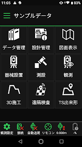
It is a field work support application specialized in civil engineering construction that follows our system "TREND-FIELD".
(Professional edition will be released as a high-performance version. * Features in blue text below)
Registered in New Technology Information System "NETIS"
NETIS is a database system developed by the Ministry of Land, Infrastructure, Transport and Tourism for the purpose of sharing and providing information for the utilization of new technology.
By using the registered technology, when public construction projects are ordered by the national government or local governments, proposing the use of the registered technology will be eligible for additional points in the construction performance evaluation. Also, if the result of using it is good, more points will be added. (Items such as the company's technological capabilities, technical proposals, environmental considerations, etc.)
Registration number: KK-200057-VE
Technical name: Field work support application "FIELD-TERRACE"
https://www.netis.mlit.go.jp/netis/input/pubsearch/details?regNo=KK-200057%20
Key features
・Collaboration with TOPCON's "Pile Navigation (LN-150), TS"
・Cooperation with TOPCON (SOKKIA) "GNSS receiver"
・Cooperation with Nikon-Trimble "Total Station"
・Easy to use with a mobile device that fits in your breast pocket
・Easy to use, simple functions and operability
・Equipped with many calculation functions necessary for civil engineering construction sites
・One-man work is possible, reducing manpower and work time.
Main Features
1) Data acquisition
FTZ/XFD/XRF/coordinate SIMA/DWG/DXF/basic design data XML/LandXML
For coordinate/CAD/route/TIN data, we support the XFD format that can be output from our CAD system and general-purpose file import.
FTZ/XFD/XRF: Fukui Computer original file format
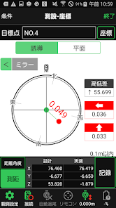
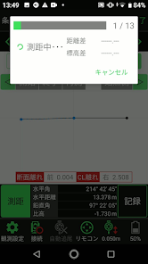
2) Stakeout
Coordinates (drawing) / route / route (measurement point) / crossing turning point
By importing coordinate/CAD/route data, in addition to surveying using coordinates, drawings, and route information, it is also possible to measure crossing change points in 3D design data.
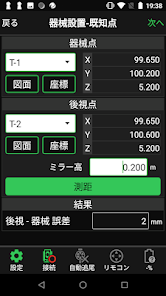
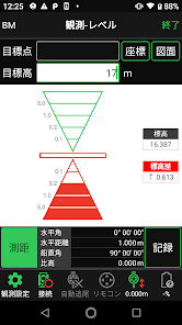
3) Observation
Coordinate/Route/Transverse Radiation/Level
By importing CAD/route data, in addition to radiation observations, it is possible to conduct observations in the longitudinal or transverse direction using the central alignment. Elevation management using TS (pile navigation) is also possible.
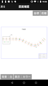
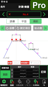
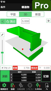
4) 3D Construction
Inspection/Inspection/Standing/Standard Section/Inspection/Inspection (TIN)/Structure/< font color="#003399">Finished form measurement
By importing CAD/Route/TIN data, it is possible to install the siding at any position and check the difference between the design and the actual measurement at any position by one person.
You can use the cross-sectional shape created with the standard section function for inspection/inspection/preparation/finished shape measurement.
In addition, it is possible to extract the cross-sectional shape at any position of the structure and guide the extracted cross-sectional shape in the side direction.
*Some functions of Inspection/Inspection/Standing/Standard Section are only available in the Professional Edition.
5) Remote Inspection
Remote inspection
Remote on-site inspection by heat map linked with our cloud service "CIMPHONY Plus" is possible.
6) TS finished form
Measurement and inspection
It is possible to manage the finished product according to the "finished product management by total station/GNSS". It can also be used for simplified ICT advocated by the Ministry of Land, Infrastructure, Transport and Tourism.
Operating Environment
For details, please check the Fukui Computer website.
・Recommended terminal models are limited.
・Installable Android version
Android 6.0~
Additional
・FIELD-TERRACE can be used as a trial version (with limited functions) after installation.
・In the trial version, you can use the installed sample data to check the connection with the measuring instrument.
・A contract (license authentication) with our company is required to use all functions.
・After installation, when you start the app, you will need permission for the folder to be used in the future.
・ Regular internet connection is required.
・When connecting to Nikon-Trimble total station "FOCUS series", it is necessary to install our application "FT-Connect".
Also, when connecting "FOCUS35", set "BT Comm" on the main unit side to the start state.
In addition, for structures, horizontal cross-sections can be extracted, and shape confirmation at a certain altitude is also possible.
We carefully selected the simple screen configuration and essential functions, and aimed to realize easy-to-understand operability so that it can be used from before the start of construction to during construction and for various inspections.
It is a field work support application specialized in civil engineering construction that follows our system "TREND-FIELD".
(Professional edition will be released as a high-performance version. * Features in blue text below)
Registered in New Technology Information System "NETIS"
NETIS is a database system developed by the Ministry of Land, Infrastructure, Transport and Tourism for the purpose of sharing and providing information for the utilization of new technology.
By using the registered technology, when public construction projects are ordered by the national government or local governments, proposing the use of the registered technology will be eligible for additional points in the construction performance evaluation. Also, if the result of using it is good, more points will be added. (Items such as the company's technological capabilities, technical proposals, environmental considerations, etc.)
Registration number: KK-200057-VE
Technical name: Field work support application "FIELD-TERRACE"
https://www.netis.mlit.go.jp/netis/input/pubsearch/details?regNo=KK-200057%20
Key features
・Collaboration with TOPCON's "Pile Navigation (LN-150), TS"
・Cooperation with TOPCON (SOKKIA) "GNSS receiver"
・Cooperation with Nikon-Trimble "Total Station"
・Easy to use with a mobile device that fits in your breast pocket
・Easy to use, simple functions and operability
・Equipped with many calculation functions necessary for civil engineering construction sites
・One-man work is possible, reducing manpower and work time.
Main Features
1) Data acquisition
FTZ/XFD/XRF/coordinate SIMA/DWG/DXF/basic design data XML/LandXML
For coordinate/CAD/route/TIN data, we support the XFD format that can be output from our CAD system and general-purpose file import.
FTZ/XFD/XRF: Fukui Computer original file format
2) Stakeout
Coordinates (drawing) / route / route (measurement point) / crossing turning point
By importing coordinate/CAD/route data, in addition to surveying using coordinates, drawings, and route information, it is also possible to measure crossing change points in 3D design data.
3) Observation
Coordinate/Route/Transverse Radiation/Level
By importing CAD/route data, in addition to radiation observations, it is possible to conduct observations in the longitudinal or transverse direction using the central alignment. Elevation management using TS (pile navigation) is also possible.
4) 3D Construction
Inspection/Inspection/Standing/Standard Section/Inspection/Inspection (TIN)/Structure/< font color="#003399">Finished form measurement
By importing CAD/Route/TIN data, it is possible to install the siding at any position and check the difference between the design and the actual measurement at any position by one person.
You can use the cross-sectional shape created with the standard section function for inspection/inspection/preparation/finished shape measurement.
In addition, it is possible to extract the cross-sectional shape at any position of the structure and guide the extracted cross-sectional shape in the side direction.
*Some functions of Inspection/Inspection/Standing/Standard Section are only available in the Professional Edition.
5) Remote Inspection
Remote inspection
Remote on-site inspection by heat map linked with our cloud service "CIMPHONY Plus" is possible.
6) TS finished form
Measurement and inspection
It is possible to manage the finished product according to the "finished product management by total station/GNSS". It can also be used for simplified ICT advocated by the Ministry of Land, Infrastructure, Transport and Tourism.
Operating Environment
For details, please check the Fukui Computer website.
・Recommended terminal models are limited.
・Installable Android version
Android 6.0~
Additional
・FIELD-TERRACE can be used as a trial version (with limited functions) after installation.
・In the trial version, you can use the installed sample data to check the connection with the measuring instrument.
・A contract (license authentication) with our company is required to use all functions.
・After installation, when you start the app, you will need permission for the folder to be used in the future.
・ Regular internet connection is required.
・When connecting to Nikon-Trimble total station "FOCUS series", it is necessary to install our application "FT-Connect".
Also, when connecting "FOCUS35", set "BT Comm" on the main unit side to the start state.
Updated on
Safety starts with understanding how developers collect and share your data. Data privacy and security practices may vary based on your use, region, and age. The developer provided this information and may update it over time.

No data shared with third parties
Learn more about how developers declare sharing

This app may collect these data types
Location, App info and performance, and Device or other IDs

Data isn’t encrypted
Data can’t be deleted