
みどり市防災ナビ
3.6star
9 reviews
1K+
Downloads

Everyone
info
About this app
"Midori City Disaster Prevention Navi" is the official app of Midori City.
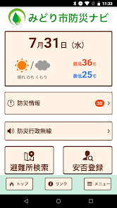
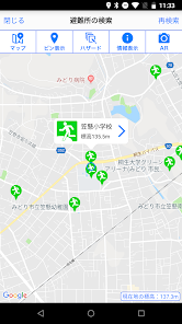
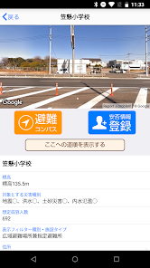
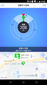
Designated evacuation shelters and designated emergency evacuation shelters around the current location and details are displayed, and the AR camera function and evacuation compass function support evacuation behavior in the event of a disaster.
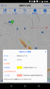
In addition, hazard maps such as sediment-related disaster warning areas, flood inundation areas, and tsunami inundation areas are also displayed, so you can check the danger of your current location.
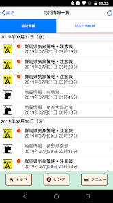
In addition, we will notify you of various disaster prevention information such as evacuation information and weather warnings by push notification.
"Midori City Disaster Prevention Navi" can be used not only in Midori City but all over the country, and the map display can be used even when offline.
[Main functions]
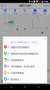
・ Automatic search for designated evacuation shelters and designated emergency evacuation shelters around your current location
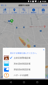
・ Hazard map display of sediment-related disaster warning areas, inundation areas, etc.
・ Display of disaster prevention information and danger information at your current location
・ AR camera function, evacuation compass function
・ Offline function
・ Push notification of disaster prevention information, list display
・ Safety registration, safety confirmation
* This app makes various access requests to enable the function, but the app provider does not collect information.
Designated evacuation shelters and designated emergency evacuation shelters around the current location and details are displayed, and the AR camera function and evacuation compass function support evacuation behavior in the event of a disaster.
In addition, hazard maps such as sediment-related disaster warning areas, flood inundation areas, and tsunami inundation areas are also displayed, so you can check the danger of your current location.
In addition, we will notify you of various disaster prevention information such as evacuation information and weather warnings by push notification.
"Midori City Disaster Prevention Navi" can be used not only in Midori City but all over the country, and the map display can be used even when offline.
[Main functions]
・ Automatic search for designated evacuation shelters and designated emergency evacuation shelters around your current location
・ Hazard map display of sediment-related disaster warning areas, inundation areas, etc.
・ Display of disaster prevention information and danger information at your current location
・ AR camera function, evacuation compass function
・ Offline function
・ Push notification of disaster prevention information, list display
・ Safety registration, safety confirmation
* This app makes various access requests to enable the function, but the app provider does not collect information.
Updated on
Safety starts with understanding how developers collect and share your data. Data privacy and security practices may vary based on your use, region, and age. The developer provided this information and may update it over time.

No data shared with third parties
Learn more about how developers declare sharing

No data collected
Learn more about how developers declare collection

Data is encrypted in transit

Data can’t be deleted
Ratings and reviews
3.6
9 reviews
What's new
トップ画面に現在地の気温が表示されるようになりました。