물때와날씨-일본지역편(일본 물때표, 바다날씨, 바다낚시
Contains ads
4.4star
96 reviews
10K+
Downloads

Everyone
info

About this app
== of "Tidal and Weather" selected by 1 million people ==
- Tide table, weather, wind, wave height, etc. for all regions of Japan (about 240 branches) at a glance ~
A must-have app for anyone who loves the sea!!!
********* Menu information *************
**Main menu - Tide (tidal forecast)/ Weather/ Wind, Wave height/ Branch information
1. Fishing information - View all areas/ Monthly tide table/ Weekly tide table/ Sea fishing video
2. National Weather - Weather Alert / National Weather / Radar Image / Satellite Image / Fog Image / Lightning Image
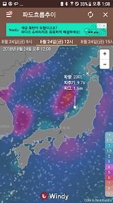
3. Japan Meteorological Agency - Wave height forecast / Precipitation forecast / Rain cloud forecast
4. Danger/disaster information - Typhoon forecast/ Typhoon trend analysis/ Red tide information/ Earthquake information/ Jellyfish information
5. Comparison of sea values - Global water temperature trend/ Daily average sea water temperature/ Wind flow trend/ Rain, cloud trend/ Wave flow trend/ Ocean current diary/ Water temperature diary/ Salinity diary
6. Ocean Weather - Ocean Weather Forecast / Buoys and Lights / Ocean Weather Information (Audio) / Regional Ocean Information (Audio) / Ocean Weather Weather Map (Expert) / Real-time Ocean Weather Observation (Map)
7. Fishing tackle - compass / flashlight
************************************************** *
special function
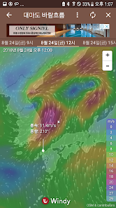
1. Wind/Fargo menu
● For the first time in Korea, it provides accurate wind speed/wind direction at 3-hour intervals, and forecasts up to 14 days, so you can get a lot of help from sea leisure activities.
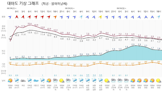
● New weather graph function that displays wind direction/wind speed/weather/precipitation/temperature/wave height on one screen - It is very useful to save images and share them on SNS.
2. Low/high tide notification settings
● You can register low tide alerts for each region and receive notifications as a ringtone.
● You can set and collectively manage your favorite regions.
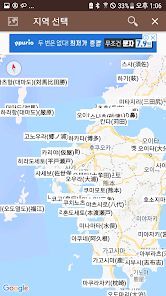
3. Provide tide and weather at over 240 branches in Japan
● About 240 tidal tables and weather forecast areas are provided.
● You can easily find various and many regions with your own favorites and search functions (Kanada search, initial consonant search, entire area search).
4. Icon and wallpaper setting function
● Set your own icon with a total of 5 icon sets
● You can designate your own wallpaper by registering your own photos or images.
5. Various weather information functions
● For the accuracy of weather inference, we provide weather data through the application of various forecasting models to compare each weather and finally make a more accurate decision.
● Reorganization of the menu system by introducing a large number of new menus (providing various weather data such as wind/wave/rain cloud trend view, red tide/jellyfish information, ocean current/salinity/water temperature image, etc.)
6. Other useful information/functions
● Various additional functions such as water flow count / monthly, weekly tide table / fishing video / flashlight function have been reinforced.
● As the menu has increased significantly, the "Menu Favorites" function has been added so that you can easily view frequently used menus.
● The ability to save tide/weather/tidal information/sea forecast on the main screen as well as wind/wave height menu as an image and share it on SNS has been added.
● A new blog (http://blog.fishingnote.co.kr) has been opened and a help function has been added to provide a forum for communication with customers.
## Information provided
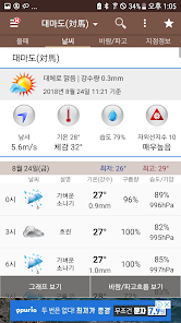
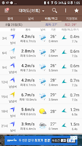
Tide (tidal forecast and tide information) - Tide table, high tide time and tide change, tide observation information (tidal level, water temperature, wind direction, temperature, wind speed, atmospheric pressure, salinity, sunrise/sunset time)
Weather - regional temperature and humidity, wind speed/wind direction, very short-term forecast, 3-hour cycle weather information, weekly weather forecast
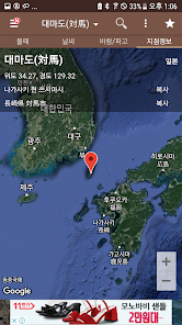
## Areas where information is displayed - About 240 locations across the coast of Japan
Kagoshima, Kanazawa, Kamaishi, Katsuura, Kawasaki, Kansai Airport Island, Konoura, Kobe, Kobo, Kochi, Kochishimoda, Kumano, Kisarazu, Nagasaki, Nagoya, Nanao, Naoetsu, Naze, Nakagusuku Port , Nakanoshima, Naha, Nemuro, Nezugaseki, Noto, Nishinomiya, Nishi-no-omote, Niigata East Port, Niigata West Port, Niihama, Tajiri, Tachibana, Takamatsu, Tateyama, Tappi, Tsushima, Teshimatsu, Toba, Tokachi, Tokyo , Tokuyama, Rausu, Reihoku, Ryotsu, Rumoi, Maisaka, Maizuru, Matsumae, Matsuyama, Makurazaki, Mera, Mori, Moji, Monbetsu, Muroran, Misaki Murotomi, Mutsuogawara, Minamata, Minami Taito, Minamiizu, Minamitorishima, Misumi, Miyazaki, Miyazu, Miyakejima (Ako), Miyakejima (Tsbota), Miyako, Mizushima, Mikawa, Mikuni, Mitajiri, Beppu, Sado, Sasebo, Saigo, Saiki , Sakai, Sakata, Sanban, Setana, Sendai New Port, Soma, Shonan Port, Sunatsu, Sumoto, Susa, Suzaki, Sutsu, Shiraoi, Shirahama, Shimoda, Shimotsu, Shimokita, Shimizu Port, Shibushi, Shiogama, Shinminato, Amagasaki, Amami, Abashiri, Aburatsu, Aburatsubo, Asamushi, Aomori, Aoki, Aohama, Awashima, Awayuki, Ayukawa, Akabane, Akashi, Akune, Akita, Yaizu, Yatsu Shiro, Esashi, Esashi, Ei, Oga, Ogi, Onahama, Onizaki, Odawara, Odomari, Oma, Omaezaki, Omuta, Ominato, Osaka, Oshoro, Oarai, Oyama no Hana, Owase, Oura, Oita, Okada, Okushiri, Okushiri Port, Okinawa, Otaru, Otoshima, Ofunato, Wajima, Wakayama, Wakkanai, Yonaguni, Yoshima, Yoshioka, Yokosuka, Yokohama, Yokkaichi Port, Uno, Uragami, Urakawa, Ube, Uwajima, Uchiura, Irozaki, Iriomote, Imabari, Imabari Island, Ishigaki, Ishinomaki, Ishikari New Port, Iwanai, Iyomishima, Izumiotsu, Izuhara Port (Tima Island), Ikuji, Ito, Itozaki, Chichijima, Choo City Fishing Port, Chofu, Tsuruga, Tsuiyama, Chiba, Chiba Port, Karatsu, Kariya, Kashima, Kashiwazaki, Katashima, Katahara , Kannoura, Kanda, Kehin Port, Kogo, Komatsushima, Kozushima, Kure, Kure, Kurushima Koro, Kumamoto, Kushiro, Kushimoto, Kuji, Kuchinotsu, Ktsugata, Kinuura, Kiritapu, Kishiwada, Tago, Tanegashima, Tanokubi, Tadotsu, Takehara, Tannowa, Tomakomai East, West Tomakomai, Tobishima, Tosashimizu, Toyama, Hagi, Hanasaki, Hadedomari, Hamada, Hashihama, Hainan, Hachinohe Port, Hachijojima (Konominato), Hachijojima (Yaene) , Hakata, Hakodate, Hosojima, Hondoseto, Honmok, Fushitoyama, Fukaura, Fukugawa Port, Fukue (Odo Islands), Hirado Seto, Hirara, Hiroshima, Himeji, Hiagari, Hiwasa, Hitachi, Hitakatsu Port (Tsuma Island)
## Disclaimer and Terms of Use
Use of data published in this app is at the user's own risk. Also, it is not valid as information for navigation. The production team of "Tidal and Weather - Japan Area Edition" is not responsible for any direct or indirect damages and potential damages that may arise from the interpretation and use of the information contained in this application.
## Scale and Weather Applications
- It is advantageous to grasp the tide and weather conditions during sea shore fishing, boat fishing, lure fishing, and sea fishing (one-throwing, walking, float fishing, etc.)
- An essential application to understand the sea weather conditions in advance before leaving for personal and club departures
- It is easy to grasp the situation of tide forecast, marine weather, national weather, typhoon, sunrise/sunset, water temperature, etc. in various fields such as photographer, diver, surf surfer, fisherman, captain, etc.
## Provide source data
Korea Meteorological Administration, National Oceanic and Atmospheric Research Institute, Korea Astronomical Institute, National Institute of Fisheries Science
- Tide table, weather, wind, wave height, etc. for all regions of Japan (about 240 branches) at a glance ~
A must-have app for anyone who loves the sea!!!
********* Menu information *************
**Main menu - Tide (tidal forecast)/ Weather/ Wind, Wave height/ Branch information
1. Fishing information - View all areas/ Monthly tide table/ Weekly tide table/ Sea fishing video
2. National Weather - Weather Alert / National Weather / Radar Image / Satellite Image / Fog Image / Lightning Image
3. Japan Meteorological Agency - Wave height forecast / Precipitation forecast / Rain cloud forecast
4. Danger/disaster information - Typhoon forecast/ Typhoon trend analysis/ Red tide information/ Earthquake information/ Jellyfish information
5. Comparison of sea values - Global water temperature trend/ Daily average sea water temperature/ Wind flow trend/ Rain, cloud trend/ Wave flow trend/ Ocean current diary/ Water temperature diary/ Salinity diary
6. Ocean Weather - Ocean Weather Forecast / Buoys and Lights / Ocean Weather Information (Audio) / Regional Ocean Information (Audio) / Ocean Weather Weather Map (Expert) / Real-time Ocean Weather Observation (Map)
7. Fishing tackle - compass / flashlight
************************************************** *
special function
1. Wind/Fargo menu
● For the first time in Korea, it provides accurate wind speed/wind direction at 3-hour intervals, and forecasts up to 14 days, so you can get a lot of help from sea leisure activities.
● New weather graph function that displays wind direction/wind speed/weather/precipitation/temperature/wave height on one screen - It is very useful to save images and share them on SNS.
2. Low/high tide notification settings
● You can register low tide alerts for each region and receive notifications as a ringtone.
● You can set and collectively manage your favorite regions.
3. Provide tide and weather at over 240 branches in Japan
● About 240 tidal tables and weather forecast areas are provided.
● You can easily find various and many regions with your own favorites and search functions (Kanada search, initial consonant search, entire area search).
4. Icon and wallpaper setting function
● Set your own icon with a total of 5 icon sets
● You can designate your own wallpaper by registering your own photos or images.
5. Various weather information functions
● For the accuracy of weather inference, we provide weather data through the application of various forecasting models to compare each weather and finally make a more accurate decision.
● Reorganization of the menu system by introducing a large number of new menus (providing various weather data such as wind/wave/rain cloud trend view, red tide/jellyfish information, ocean current/salinity/water temperature image, etc.)
6. Other useful information/functions
● Various additional functions such as water flow count / monthly, weekly tide table / fishing video / flashlight function have been reinforced.
● As the menu has increased significantly, the "Menu Favorites" function has been added so that you can easily view frequently used menus.
● The ability to save tide/weather/tidal information/sea forecast on the main screen as well as wind/wave height menu as an image and share it on SNS has been added.
● A new blog (http://blog.fishingnote.co.kr) has been opened and a help function has been added to provide a forum for communication with customers.
## Information provided
Tide (tidal forecast and tide information) - Tide table, high tide time and tide change, tide observation information (tidal level, water temperature, wind direction, temperature, wind speed, atmospheric pressure, salinity, sunrise/sunset time)
Weather - regional temperature and humidity, wind speed/wind direction, very short-term forecast, 3-hour cycle weather information, weekly weather forecast
## Areas where information is displayed - About 240 locations across the coast of Japan
Kagoshima, Kanazawa, Kamaishi, Katsuura, Kawasaki, Kansai Airport Island, Konoura, Kobe, Kobo, Kochi, Kochishimoda, Kumano, Kisarazu, Nagasaki, Nagoya, Nanao, Naoetsu, Naze, Nakagusuku Port , Nakanoshima, Naha, Nemuro, Nezugaseki, Noto, Nishinomiya, Nishi-no-omote, Niigata East Port, Niigata West Port, Niihama, Tajiri, Tachibana, Takamatsu, Tateyama, Tappi, Tsushima, Teshimatsu, Toba, Tokachi, Tokyo , Tokuyama, Rausu, Reihoku, Ryotsu, Rumoi, Maisaka, Maizuru, Matsumae, Matsuyama, Makurazaki, Mera, Mori, Moji, Monbetsu, Muroran, Misaki Murotomi, Mutsuogawara, Minamata, Minami Taito, Minamiizu, Minamitorishima, Misumi, Miyazaki, Miyazu, Miyakejima (Ako), Miyakejima (Tsbota), Miyako, Mizushima, Mikawa, Mikuni, Mitajiri, Beppu, Sado, Sasebo, Saigo, Saiki , Sakai, Sakata, Sanban, Setana, Sendai New Port, Soma, Shonan Port, Sunatsu, Sumoto, Susa, Suzaki, Sutsu, Shiraoi, Shirahama, Shimoda, Shimotsu, Shimokita, Shimizu Port, Shibushi, Shiogama, Shinminato, Amagasaki, Amami, Abashiri, Aburatsu, Aburatsubo, Asamushi, Aomori, Aoki, Aohama, Awashima, Awayuki, Ayukawa, Akabane, Akashi, Akune, Akita, Yaizu, Yatsu Shiro, Esashi, Esashi, Ei, Oga, Ogi, Onahama, Onizaki, Odawara, Odomari, Oma, Omaezaki, Omuta, Ominato, Osaka, Oshoro, Oarai, Oyama no Hana, Owase, Oura, Oita, Okada, Okushiri, Okushiri Port, Okinawa, Otaru, Otoshima, Ofunato, Wajima, Wakayama, Wakkanai, Yonaguni, Yoshima, Yoshioka, Yokosuka, Yokohama, Yokkaichi Port, Uno, Uragami, Urakawa, Ube, Uwajima, Uchiura, Irozaki, Iriomote, Imabari, Imabari Island, Ishigaki, Ishinomaki, Ishikari New Port, Iwanai, Iyomishima, Izumiotsu, Izuhara Port (Tima Island), Ikuji, Ito, Itozaki, Chichijima, Choo City Fishing Port, Chofu, Tsuruga, Tsuiyama, Chiba, Chiba Port, Karatsu, Kariya, Kashima, Kashiwazaki, Katashima, Katahara , Kannoura, Kanda, Kehin Port, Kogo, Komatsushima, Kozushima, Kure, Kure, Kurushima Koro, Kumamoto, Kushiro, Kushimoto, Kuji, Kuchinotsu, Ktsugata, Kinuura, Kiritapu, Kishiwada, Tago, Tanegashima, Tanokubi, Tadotsu, Takehara, Tannowa, Tomakomai East, West Tomakomai, Tobishima, Tosashimizu, Toyama, Hagi, Hanasaki, Hadedomari, Hamada, Hashihama, Hainan, Hachinohe Port, Hachijojima (Konominato), Hachijojima (Yaene) , Hakata, Hakodate, Hosojima, Hondoseto, Honmok, Fushitoyama, Fukaura, Fukugawa Port, Fukue (Odo Islands), Hirado Seto, Hirara, Hiroshima, Himeji, Hiagari, Hiwasa, Hitachi, Hitakatsu Port (Tsuma Island)
## Disclaimer and Terms of Use
Use of data published in this app is at the user's own risk. Also, it is not valid as information for navigation. The production team of "Tidal and Weather - Japan Area Edition" is not responsible for any direct or indirect damages and potential damages that may arise from the interpretation and use of the information contained in this application.
## Scale and Weather Applications
- It is advantageous to grasp the tide and weather conditions during sea shore fishing, boat fishing, lure fishing, and sea fishing (one-throwing, walking, float fishing, etc.)
- An essential application to understand the sea weather conditions in advance before leaving for personal and club departures
- It is easy to grasp the situation of tide forecast, marine weather, national weather, typhoon, sunrise/sunset, water temperature, etc. in various fields such as photographer, diver, surf surfer, fisherman, captain, etc.
## Provide source data
Korea Meteorological Administration, National Oceanic and Atmospheric Research Institute, Korea Astronomical Institute, National Institute of Fisheries Science
Updated on
Data safety
Developers can show information here about how their app collects and uses your data. Learn more about data safety

No information available
Ratings and reviews
4.4
96 reviews
What's new
일부 예보 영상이 표시되지 않던 문제를 수정하였습니다.
링크 오류 수정.
링크 오류 수정.