SmartTopo C(스마트토포)
1K+
Downloads

Everyone
info
About this app
>> Home Page
www.stopo.co.kr
SmartTopo Catalyst version released!
SmartTopo C major update features
■ Main Updated Function
-R10 Model2 w ProPoint
-R12
-Inclination survey using R10, R12 GNSS receiver internal sensors
■ Main function
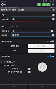
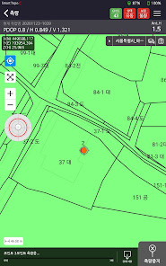
-Real-time GNSS survey
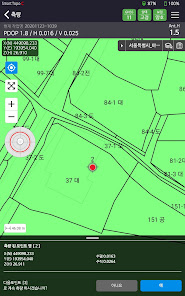
-Road surveying
-Stake out points
-Points, lines, and faces can be surveyed
-Possible to express symbol type by code
-Network RTK(VRS) support
-Real-time site calibration support
-Naver map support
-Supports many background maps such as dxf, shp, gsf, aerial photograph (tif)
-Slope correction survey
-Voice recognition survey
-Data export
-Line stakeout
-Cadastral map download
-Search for nearby cadastral maps
-Added SkyPlot
Addition of many other convenience functions
■ Environment
(Minimum specification)
-Android OS 5.1.1 (Lollipop)
-CPU 1.2GHz (Quad Core)
-1.5GB of RAM
(Recommended specification)
-Android OS 8.1.0 (Oreo)
-CPU 1.6GHz (octa-core)
-RAM 3GB
※ It is possible to use and check functions other than GPS connection through'Internal Work'.
For formal license issuance, smarttopo@geosys.co.kr
Please contact us.
Geosystem Co., Ltd.
www.stopo.co.kr
SmartTopo Catalyst version released!
SmartTopo C major update features
■ Main Updated Function
-R10 Model2 w ProPoint
-R12
-Inclination survey using R10, R12 GNSS receiver internal sensors
■ Main function
-Real-time GNSS survey
-Road surveying
-Stake out points
-Points, lines, and faces can be surveyed
-Possible to express symbol type by code
-Network RTK(VRS) support
-Real-time site calibration support
-Naver map support
-Supports many background maps such as dxf, shp, gsf, aerial photograph (tif)
-Slope correction survey
-Voice recognition survey
-Data export
-Line stakeout
-Cadastral map download
-Search for nearby cadastral maps
-Added SkyPlot
Addition of many other convenience functions
■ Environment
(Minimum specification)
-Android OS 5.1.1 (Lollipop)
-CPU 1.2GHz (Quad Core)
-1.5GB of RAM
(Recommended specification)
-Android OS 8.1.0 (Oreo)
-CPU 1.6GHz (octa-core)
-RAM 3GB
※ It is possible to use and check functions other than GPS connection through'Internal Work'.
For formal license issuance, smarttopo@geosys.co.kr
Please contact us.
Geosystem Co., Ltd.
Updated on
Data safety
Developers can show information here about how their app collects and uses your data. Learn more about data safety

No information available
What's new
- 원형 해치 문제 오류 수정


