
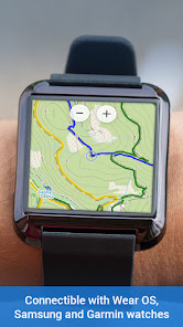
Locus Map 4 Outdoor Navigation
Contient des annoncesAchats via l'appli

4,4star
57,7K avis
5M+
Téléchargements

Tout public
info


À propos de l'application
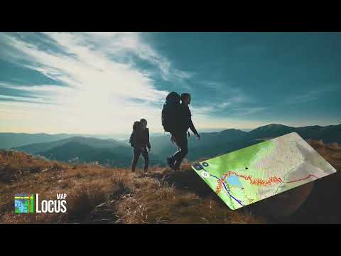
Locus Map is a multifunctional navigation app with offline maps for a delightful outdoor experience.
It can plan, edit, record, save, or share routes and tracks of your trips, track your workout performance, and much more. Locus Map is designed for all outdoor activities - hiking, mountain biking, cycling, trail running, geocaching, cross-country skiing, and others.
It is fully customizable and flexible, offering a wide range of cool functions running above a variety of maps of the whole world.
Planning, recording and managing your activities:
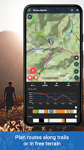
• plan routes along hiking trails, bike trails, or in an open terrain within the app or on the web
• record tracks with all useful stats – distance, speed, pace, height gain, calorie burn, and others
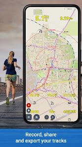
• import and export the routes in various formats (GPX, KMZ, TCX...)
• share your tracks to Strava, Runkeeper, or Google Earth
• create your private database of favorite places
• browse your geotagged photos on the map
• import and export points of interest in various formats
Offline navigation and guiding:
• turn-by-turn voice instructions or sound signals
• out-of route alert
• navigation of routes planned within the app or imported from outside of Locus
• beeline guidance in an open terrain
Geocaching tools:
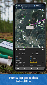
• download of caches for offline play
• navigation to caches above the map or using the compass
• online and offline logging
• graphic and calculation tools
• logs and drafts management
• notification of a nearby geocache
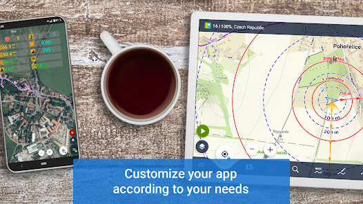
Customizing options:
• fully configurable main menu
• fully configurable main screen panels
• right/left-hand control, light/dark mode...
• selection of coords system, units, dashboards, and screens
• configuration presets for fluent multifunctional app use
Wide selection of maps:
LoMaps - online/offline maps of the whole world based on OSM
• millions of dynamic points of interest
• offline addresses
• switchable to hiking/biking map, winter or city map. Download 3 of them for FREE.
Global satellite maps
• Here and Maxar based
• cacheable for up to one year
Outdoor maps by the world’s best cartographic publishers
• UK - Ordnance Survey Landranger and Explorer maps
• other Europe - Outdooractive, (Germany, Austria, Italy), IGN (France, Belgium), Swisstopo (Switzerland) and many others...
• USA&Canada - USGS classic/satellite, AccuTerra trail maps, Backroad Map Books
• support for external maps in SQLite, TAR, MBT, or GEMF formats
Get even more with the Premium features
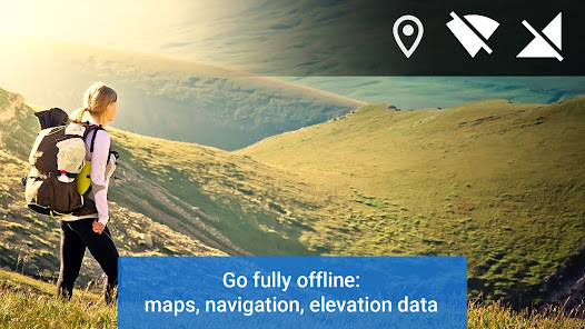
Go fully offline
• enjoy offline LoMaps of the whole world including updates without extra charges
• navigate and plan routes with the built-in offline router
• display the elevation of any place on Earth without an internet connection
Keep synced
• sync your tracks, routes, and points across multiple devices and your personal web library
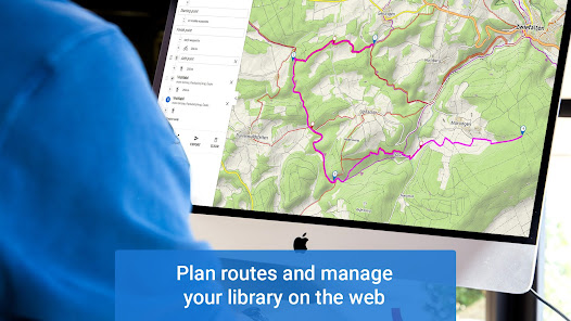
Go web
• plan routes on a big PC screen, and sync them with your mobile devices
• browse, view, and manage your routes and tracks in a web library
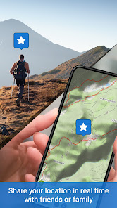
Go live
• share your location in real-time with your family or friends in your own private live tracking groups
Sport packet
• connect the app with BT/ANT+ sensors
• work out with an audio coach
• monitor your rides on a dashboard with handsfree screen control
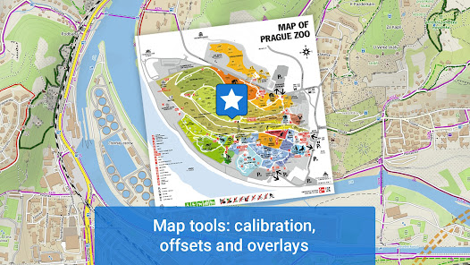
Map tools
• map images calibration
• overlay of two various maps
And much more...
• 24/7 weather forecast on any place on Earth
• parking assistant
• no ads
The app uses the Device Administrator's permission.
It can plan, edit, record, save, or share routes and tracks of your trips, track your workout performance, and much more. Locus Map is designed for all outdoor activities - hiking, mountain biking, cycling, trail running, geocaching, cross-country skiing, and others.
It is fully customizable and flexible, offering a wide range of cool functions running above a variety of maps of the whole world.
Planning, recording and managing your activities:
• plan routes along hiking trails, bike trails, or in an open terrain within the app or on the web
• record tracks with all useful stats – distance, speed, pace, height gain, calorie burn, and others
• import and export the routes in various formats (GPX, KMZ, TCX...)
• share your tracks to Strava, Runkeeper, or Google Earth
• create your private database of favorite places
• browse your geotagged photos on the map
• import and export points of interest in various formats
Offline navigation and guiding:
• turn-by-turn voice instructions or sound signals
• out-of route alert
• navigation of routes planned within the app or imported from outside of Locus
• beeline guidance in an open terrain
Geocaching tools:
• download of caches for offline play
• navigation to caches above the map or using the compass
• online and offline logging
• graphic and calculation tools
• logs and drafts management
• notification of a nearby geocache
Customizing options:
• fully configurable main menu
• fully configurable main screen panels
• right/left-hand control, light/dark mode...
• selection of coords system, units, dashboards, and screens
• configuration presets for fluent multifunctional app use
Wide selection of maps:
LoMaps - online/offline maps of the whole world based on OSM
• millions of dynamic points of interest
• offline addresses
• switchable to hiking/biking map, winter or city map. Download 3 of them for FREE.
Global satellite maps
• Here and Maxar based
• cacheable for up to one year
Outdoor maps by the world’s best cartographic publishers
• UK - Ordnance Survey Landranger and Explorer maps
• other Europe - Outdooractive, (Germany, Austria, Italy), IGN (France, Belgium), Swisstopo (Switzerland) and many others...
• USA&Canada - USGS classic/satellite, AccuTerra trail maps, Backroad Map Books
• support for external maps in SQLite, TAR, MBT, or GEMF formats
Get even more with the Premium features
Go fully offline
• enjoy offline LoMaps of the whole world including updates without extra charges
• navigate and plan routes with the built-in offline router
• display the elevation of any place on Earth without an internet connection
Keep synced
• sync your tracks, routes, and points across multiple devices and your personal web library
Go web
• plan routes on a big PC screen, and sync them with your mobile devices
• browse, view, and manage your routes and tracks in a web library
Go live
• share your location in real-time with your family or friends in your own private live tracking groups
Sport packet
• connect the app with BT/ANT+ sensors
• work out with an audio coach
• monitor your rides on a dashboard with handsfree screen control
Map tools
• map images calibration
• overlay of two various maps
And much more...
• 24/7 weather forecast on any place on Earth
• parking assistant
• no ads
The app uses the Device Administrator's permission.
Date de mise à jour
La sécurité, c'est d'abord comprendre comment les développeurs collectent et partagent vos données. Les pratiques concernant leur confidentialité et leur protection peuvent varier selon votre utilisation, votre région et votre âge. Le développeur a fourni ces informations et peut les modifier ultérieurement.


Notes et avis
4,3
54,5K avis
Nouveautés
*** Locus Map 4.23 ***
- add: basic support for Lab geocaches
- add: POI information for every photo in the user's LoPoint photo gallery
- chg: completely new image gallery for comfortable display of multiple full-screen images
- and more
- add: basic support for Lab geocaches
- add: POI information for every photo in the user's LoPoint photo gallery
- chg: completely new image gallery for comfortable display of multiple full-screen images
- and more


