서울특별시버스
Contains ads
1K+
Downloads

Everyone
info

About this app
Based on public data (www.data.go.kr), you can check various information on the operation of Seoul buses (airport, town, city, circulation, and metropolitan) and Incheon and Gyeonggi buses passing through Seoul.
Depending on network conditions, errors may occur or information provision may be delayed.
In the case of Incheon and Gyeonggi buses, some functions are not provided.
[- main function -]
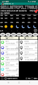
[time/weather]
-. If you swipe left or right on the screen from the home of the app, you can check the moving bus / time / super simple weather forecast (next 6 hours). If you select the pushpin at the top right of Home, the selected widget will be executed immediately at the next launch.
[Shortcuts]
-. Register frequently used bus routes as shortcuts
-. Register frequently used stops as shortcuts
-. If you select a shortcut and select a bus/stop the next time you run it, you can go directly to the bus or stop without going through the home of the app the next time you run it.
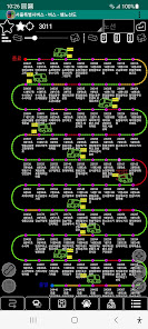
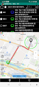
[Bus locations in operation (6 types)]
- .Provision of route and real-time bus location.
- Provide route route
[number of passengers]
-. You can check the number of passengers on all buses on the route, so you can board a spare bus.
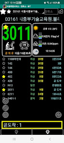
[Stop arrival information (2 types)]
-. Stop search and bus arrival time
-. Find nearby stops linked with GPS
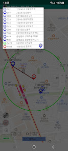
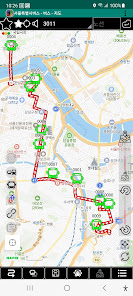
[Route driving]
-. Bus -> If you select the driving icon at the top of the map, you can check the GPS-based location according to the update time.
-. If you select a ride bus and select the bus tracking icon, you can check the location of the ride bus according to the update time.
[Disembarkation Notice]
-. In Bus -> Details, select the bus and drop-off stop and select Start Guide to check the estimated arrival time and remaining time. You can send this content to SNS, so you can reduce the anxiety of people who have appointments or are waiting.
[Transfer Search]
-. Based on the main route, the stop where the two bus routes meet is indicated in blue for the direction of the end point and red for the direction of the origin.
[Bus Route Search]
-. Select a departure and arrival location on the map to see a list of direct bus routes or possible transfers.
[Stop Search]
-. If you select a place on the map, you can see the stops within the selected range on the map, and if you select a stop, you can check the bus arrival information.
[Ttareungi location search]
-. If you select a place on the map, you can check the location of Ttareungi within the selected area.
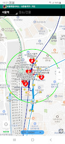
[Toilet location]
-. When you select a place on the map, you can see public/public restroom locations within the selected range.
[Seoul Metropolitan Subway/Cheoncheol Station Search]
-. If you select a place on the map, you can check the exit number of the nearest station for each line within the range.
[Guidance on access rights]
-Location permission: Location information permission is required to search for nearby stops and bus locations.
-Storage space: Permission required to save route data.
Data source: The source of this data was created based on the public data (www.data.go.kr) of the Korean government.
This app does not represent the Republic of Korea and each local government in any case.
Depending on network conditions, errors may occur or information provision may be delayed.
In the case of Incheon and Gyeonggi buses, some functions are not provided.
[- main function -]
[time/weather]
-. If you swipe left or right on the screen from the home of the app, you can check the moving bus / time / super simple weather forecast (next 6 hours). If you select the pushpin at the top right of Home, the selected widget will be executed immediately at the next launch.
[Shortcuts]
-. Register frequently used bus routes as shortcuts
-. Register frequently used stops as shortcuts
-. If you select a shortcut and select a bus/stop the next time you run it, you can go directly to the bus or stop without going through the home of the app the next time you run it.
[Bus locations in operation (6 types)]
- .Provision of route and real-time bus location.
- Provide route route
[number of passengers]
-. You can check the number of passengers on all buses on the route, so you can board a spare bus.
[Stop arrival information (2 types)]
-. Stop search and bus arrival time
-. Find nearby stops linked with GPS
[Route driving]
-. Bus -> If you select the driving icon at the top of the map, you can check the GPS-based location according to the update time.
-. If you select a ride bus and select the bus tracking icon, you can check the location of the ride bus according to the update time.
[Disembarkation Notice]
-. In Bus -> Details, select the bus and drop-off stop and select Start Guide to check the estimated arrival time and remaining time. You can send this content to SNS, so you can reduce the anxiety of people who have appointments or are waiting.
[Transfer Search]
-. Based on the main route, the stop where the two bus routes meet is indicated in blue for the direction of the end point and red for the direction of the origin.
[Bus Route Search]
-. Select a departure and arrival location on the map to see a list of direct bus routes or possible transfers.
[Stop Search]
-. If you select a place on the map, you can see the stops within the selected range on the map, and if you select a stop, you can check the bus arrival information.
[Ttareungi location search]
-. If you select a place on the map, you can check the location of Ttareungi within the selected area.
[Toilet location]
-. When you select a place on the map, you can see public/public restroom locations within the selected range.
[Seoul Metropolitan Subway/Cheoncheol Station Search]
-. If you select a place on the map, you can check the exit number of the nearest station for each line within the range.
[Guidance on access rights]
-Location permission: Location information permission is required to search for nearby stops and bus locations.
-Storage space: Permission required to save route data.
Data source: The source of this data was created based on the public data (www.data.go.kr) of the Korean government.
This app does not represent the Republic of Korea and each local government in any case.
Updated on
Safety starts with understanding how developers collect and share your data. Data privacy and security practices may vary based on your use, region, and age. The developer provided this information and may update it over time.

No data shared with third parties
Learn more about how developers declare sharing

This app may collect these data types
Location and Messages

Data is encrypted in transit

Data can’t be deleted
What's new
v 4.9.5
공공데이터(OPEN-API)자료 기반으로하여 서울특별시 등록 버스 와 서울시를 경유하는 인천버스와 경기버스의 운행 정보를 다양하게 확인할 수 있습니다.
네트워크 상황에 따라 오차가 발생하거나 정보 제공이 지연될 수 있습니다.
인천버스, 경기버스의 경우 일부 기능이 제공되지 않습니다.
서울시 실시간 통제 또는 우회정류소를 표시합니다.
자동심장충격기(자동제세동기, AED) 위치 제공합니다.
서울시 따릉이 위치를 지도에서 지원합니다.
서울시 공공/개방 화장실 위치를 지도에서 지원합니다.
수도권 지하철/전철역의 가장 가까운 출입구 위치를 지도에서 지원합니다.
기상청 초간단예보(6시간)를 지원합니다.
한국환경공단에서 제공하는 에어코리아 대기환경 서비스를 지원합니다.
안드로이드 15 지원.


