SeaWi Marine
In-app purchases
2.8star
161 reviews
10K+
Downloads

Everyone
info


About this app
A full Navigation Tool for Android Tablets and Phones and the best Navigation aid Tool for Sailors.
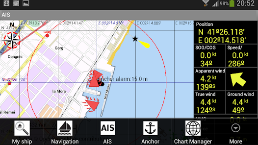
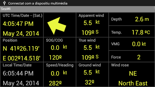
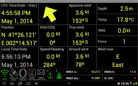
Navigation Data
Visualize navigation data on your phone or tablet: position, SOG, COG, speed, heading, apparent wind, true wind, ground wind, VMG, Beaufort force, depth, water temperature, UTC time. (A NMEA 2000® or a NMEA 0183 WiFi adaptor is required to receive NMEA data. SeaWi decodes NMEA 2000® and NMEA 0183 data received in TPC, UDP Unicast and Multicast packets).
You can also use the built-in GPS of your device to show position, SOG, COG and UTC time.
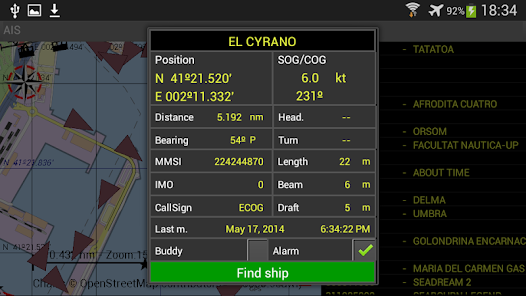
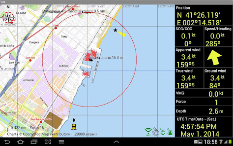
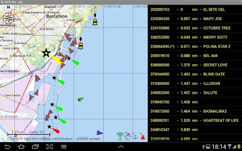
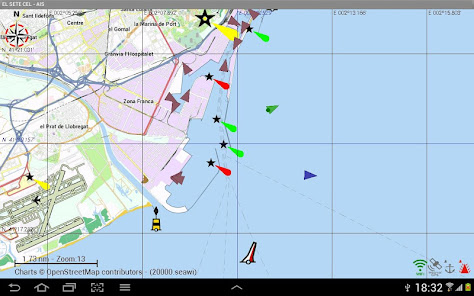
AIS Targets
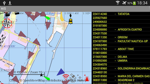
SeaWi decodes AIS information and allows you to visualize AIS target information on your phone or tablet: AIS target name and MMSI, AIS target position, AIS target SOG, AIS target COG, distance and bearing from your vessel, heading, rate of turn, length, beam, draft, IMO, Callsign. SeaWi shows AIS targets on the chart and triggers alarms for dangerous AIS targets or AIS target lost. (An AIS receiver and a NMEA 2000® or a 38400 baud NMEA 0183 WiFi adaptor; or a WiFi AIS receiver is required to receive AIS info).
You can select your buddies and keep track of them.
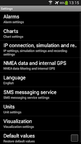
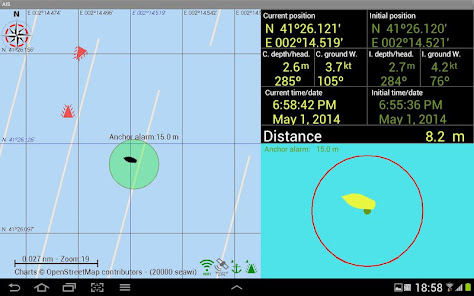
Alarms
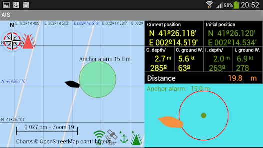
SeaWi allows you to program multiple alarms: anchor alarms, depth alarms (shallow water alarm, deep water alarm), alarm of lost data (depth data lost, heading data lost, position data lost, apparent wind data lost) and AIS alarms (dangerous AIS target, lost AIS target).
Tracks
You can create a track tapping the Create new track button from the Track View. The tracks are saved and may be visualized at any time.
You may configure the time period or the distance between track point creation and the number of viewed points at high resolution.
You may continue a saved track whenever you need it.
Waypoints
You can create a waypoint tapping and holding on a chart position. Once the waypoint dialog appears you can modify the waypoint position and place the waypoint at your vessel’s position or at a position of your choosing. You can mark the waypoint with six different symbols: generic waypoint, anchorage waypoint, diving waypoint, fishing waypoint, dangerous waypoint and MOB waypoint. You may add a photo to your preferred waypoints.
Man Over Board (MOB)
You can create a Man Over Board waypoint with only one click (menu MOB). Your vessel's position and UTC time and date will be automatically saved. You can manage the MOB mark as a waypoint from waypoints view.
SMS Service
The SMS Service allows you to receive SMS messages when an alarm is activated. If you are anchored and you are not on board you can program alarms (anchor alarm, depth alarm, dangerous AIS target alarm or lost data alarm) and receive them on your phone. When not on board you can schedule SMS messages at certain intervals of time and receive navigational data from your vessel on your phone.
SeaWi NMEA forwarding
You can forward all navigation and AIS data where you need them. Forward NMEA data to other tablets and phones on your boat. Forward NMEA data remotely and use SeaWi app to visualize the same navigational and AIS data as if you where aboard.
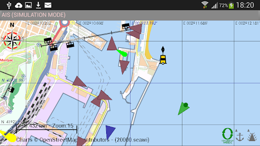
Log Trip and Simulation Mode
You can record navigational data of your trip and recover them later to review your trip in Simulation Mode.
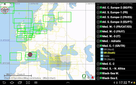
Charts
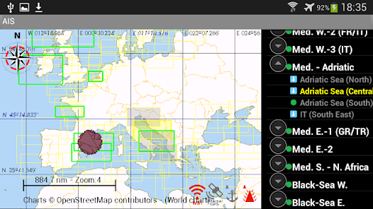
Off-line OpenSeaMaps charts of the entire world are available. Currently charts of Europe, North America, Mediterranean Sea, Black Sea, Caribbean, Australia, New Zealand, Pacific and North Africa are available. Charts of the rest of the world will be available soon.
OpenSeaMap is an open source, worldwide project to create a free nautical chart. In 2009, OpenSeaMap came into life. This map includes beacons, buoys and other navigation aids. OpenSeaMap is a subproject of OpenStreetMap and uses its database.
Navigation Data
Visualize navigation data on your phone or tablet: position, SOG, COG, speed, heading, apparent wind, true wind, ground wind, VMG, Beaufort force, depth, water temperature, UTC time. (A NMEA 2000® or a NMEA 0183 WiFi adaptor is required to receive NMEA data. SeaWi decodes NMEA 2000® and NMEA 0183 data received in TPC, UDP Unicast and Multicast packets).
You can also use the built-in GPS of your device to show position, SOG, COG and UTC time.
AIS Targets
SeaWi decodes AIS information and allows you to visualize AIS target information on your phone or tablet: AIS target name and MMSI, AIS target position, AIS target SOG, AIS target COG, distance and bearing from your vessel, heading, rate of turn, length, beam, draft, IMO, Callsign. SeaWi shows AIS targets on the chart and triggers alarms for dangerous AIS targets or AIS target lost. (An AIS receiver and a NMEA 2000® or a 38400 baud NMEA 0183 WiFi adaptor; or a WiFi AIS receiver is required to receive AIS info).
You can select your buddies and keep track of them.
Alarms
SeaWi allows you to program multiple alarms: anchor alarms, depth alarms (shallow water alarm, deep water alarm), alarm of lost data (depth data lost, heading data lost, position data lost, apparent wind data lost) and AIS alarms (dangerous AIS target, lost AIS target).
Tracks
You can create a track tapping the Create new track button from the Track View. The tracks are saved and may be visualized at any time.
You may configure the time period or the distance between track point creation and the number of viewed points at high resolution.
You may continue a saved track whenever you need it.
Waypoints
You can create a waypoint tapping and holding on a chart position. Once the waypoint dialog appears you can modify the waypoint position and place the waypoint at your vessel’s position or at a position of your choosing. You can mark the waypoint with six different symbols: generic waypoint, anchorage waypoint, diving waypoint, fishing waypoint, dangerous waypoint and MOB waypoint. You may add a photo to your preferred waypoints.
Man Over Board (MOB)
You can create a Man Over Board waypoint with only one click (menu MOB). Your vessel's position and UTC time and date will be automatically saved. You can manage the MOB mark as a waypoint from waypoints view.
SMS Service
The SMS Service allows you to receive SMS messages when an alarm is activated. If you are anchored and you are not on board you can program alarms (anchor alarm, depth alarm, dangerous AIS target alarm or lost data alarm) and receive them on your phone. When not on board you can schedule SMS messages at certain intervals of time and receive navigational data from your vessel on your phone.
SeaWi NMEA forwarding
You can forward all navigation and AIS data where you need them. Forward NMEA data to other tablets and phones on your boat. Forward NMEA data remotely and use SeaWi app to visualize the same navigational and AIS data as if you where aboard.
Log Trip and Simulation Mode
You can record navigational data of your trip and recover them later to review your trip in Simulation Mode.
Charts
Off-line OpenSeaMaps charts of the entire world are available. Currently charts of Europe, North America, Mediterranean Sea, Black Sea, Caribbean, Australia, New Zealand, Pacific and North Africa are available. Charts of the rest of the world will be available soon.
OpenSeaMap is an open source, worldwide project to create a free nautical chart. In 2009, OpenSeaMap came into life. This map includes beacons, buoys and other navigation aids. OpenSeaMap is a subproject of OpenStreetMap and uses its database.
Updated on
Safety starts with understanding how developers collect and share your data. Data privacy and security practices may vary based on your use, region, and age. The developer provided this information and may update it over time.

No data shared with third parties
Learn more about how developers declare sharing

No data collected
Learn more about how developers declare collection
Ratings and reviews
2.8
119 reviews

Leon Jennings
- Flag inappropriate
July 20, 2020
ok it took a while but I got settings sorted and now this great little app works fine on my NeoCore tablet Android. I have the premium licence and yes its great. Problem is for some reason it will not work on my Pixel3XL I have tried everything and it just won't work. im using a generic nmea2wifi box sending simulation data and as I said above it works fine, but it will not work on the phone despite a good connection. Come on guys how do I make this work?????????

Trevor Stokes
- Flag inappropriate
June 27, 2020
Do the NMEA sentences have to include the checksum? My older Stowe dataline databox (through a NMEA WiFi converter) does not include a checksum and SeaWi seems to ignore them. Otherwise, for those with newer databoxes I'm sure this app is very good.

A Google user
- Flag inappropriate
- Show review history
September 17, 2018
SeaWi requires too many permissions, won't run without them. Even with the superfluous permissions granted the app crashes before it opens. Useless.
1 person found this review helpful
What's new
- Alarm notification issue solved
- Support for Android 10 and new SeaWi Directory tree
- Due to Google restrictions, this version does not support SMS messages (a full functional version can be downloaded from www.SeaWiMarine.net/downloads/)
- Support for $PCDIN (Version 1.7) NMEA2000 to NMEA0183 conversion (Beta)
- Support for $MXPGN NMEA2000 to NMEA0183 conversion (Beta)
- ip port can be lower than 1024