NZ Topo50 Offline - North
10K+
Downloads

Everyone
info
About this app
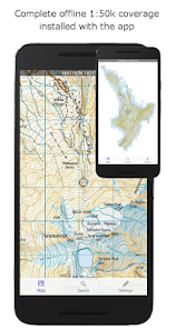
Complete 1:50k offline topographic map coverage using the LINZ NZTopo50 series maps. The maps are included fully with the install. No additional downloads, no account signup, no missing tiles, no added fees, just seamless offline pan and zoom across the whole North Island.
Ideal for back country navigation without cell phone access. Popular with trampers, walkers, bikers, runners, hunters, search and rescue, Te Araroa walkers.
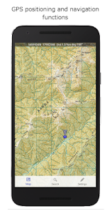
Navigation functions includes GPS positioning, track logging, user waypoints, orientation (compass), altitude and speed display, distance and bearing to points on the map, route creation and following. Search for and zoom to named places and features on the map. Tracks and waypoints can be imported, exported, and shared in kml or gpx format.
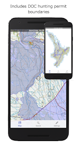
Overlays showing DOC open permit hunting boundaries, Te Araroa tracks, and other data is included.
This app is built from the ground up to use the NZ national map grid, not the global average WGS84 datum commonly used which distorts the map. This is easy to spot. A true NZ grid will give you perfectly parallel gridlines when the LINZ map is projected onto it.
No internet or cellular phone connection is needed for full use of all the maps and navigation functions.
The storage space required for this app is reasonably large. Ensure you have sufficient space available.
Made in NZ.
Ideal for back country navigation without cell phone access. Popular with trampers, walkers, bikers, runners, hunters, search and rescue, Te Araroa walkers.
Navigation functions includes GPS positioning, track logging, user waypoints, orientation (compass), altitude and speed display, distance and bearing to points on the map, route creation and following. Search for and zoom to named places and features on the map. Tracks and waypoints can be imported, exported, and shared in kml or gpx format.
Overlays showing DOC open permit hunting boundaries, Te Araroa tracks, and other data is included.
This app is built from the ground up to use the NZ national map grid, not the global average WGS84 datum commonly used which distorts the map. This is easy to spot. A true NZ grid will give you perfectly parallel gridlines when the LINZ map is projected onto it.
No internet or cellular phone connection is needed for full use of all the maps and navigation functions.
The storage space required for this app is reasonably large. Ensure you have sufficient space available.
Made in NZ.
Updated on
Safety starts with understanding how developers collect and share your data. Data privacy and security practices may vary based on your use, region, and age. The developer provided this information and may update it over time.

No data shared with third parties
Learn more about how developers declare sharing

No data collected
Learn more about how developers declare collection
What's new
Updated content