WaterstandLimburg
10K+
Downloads

Everyone
info
About this app
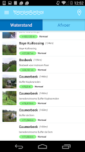
Water Limburg. The name says it all: through this app Water Limburg 24/7 to see the water level of many points in Limburg streams. The water level of the river Meuse in Limburg is clear: this water data comes from Rijkswaterstaat.
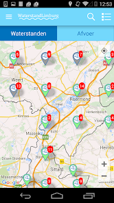
Besides the water level is also asking the drain. Through an interactive map of Limburg all points easy to approach and once zoomed in on a measuring point is indicated via four color codes if there is a normal state of such (potential) flooding.
Using the built-in GPS function allows you to quickly see the closest points in your area (and possibly set alerts). Also this current water data can be shared easily via various social media channels.
In addition this application is also available www.waterstandlimburg.nl.
More information about Water Limburg via:
www.waterschaplimburg.nl
Besides the water level is also asking the drain. Through an interactive map of Limburg all points easy to approach and once zoomed in on a measuring point is indicated via four color codes if there is a normal state of such (potential) flooding.
Using the built-in GPS function allows you to quickly see the closest points in your area (and possibly set alerts). Also this current water data can be shared easily via various social media channels.
In addition this application is also available www.waterstandlimburg.nl.
More information about Water Limburg via:
www.waterschaplimburg.nl
Updated on
Safety starts with understanding how developers collect and share your data. Data privacy and security practices may vary based on your use, region, and age. The developer provided this information and may update it over time.

No data shared with third parties
Learn more about how developers declare sharing

No data collected
Learn more about how developers declare collection

Data is encrypted in transit
What's new
Ondersteuning voor Android 13