
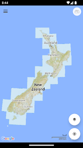
New Zealand (NZ) Topo Map
Contains adsIn-app purchases
4.6star
114 reviews
10K+
Downloads

Everyone
info

About this app
Topographic map of New Zealand with no limitations:
• View and cache topographic tiles and satellite imagery
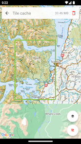
• Download all topographic tiles in a visible region (for offline availability)
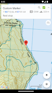
• Add unlimited map markers
• Import GPX / KML / FIT waypoints, tracks and routes
• Record routes (export and share)
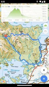
• View track / route elevation profile (with interactive graph)
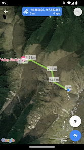
• Measure distance (in a straight line) between multiple points and markers
• Search for places of interest (supports decimal and NZTM2000 coordinates)
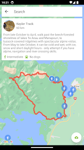
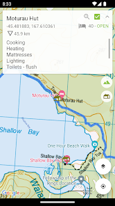
• Search and view DOC huts (tap a hut marker for more information)
• Search and view DOC tracks (import tracks for offline availability)
• Topographic imagery for Antipodes, Auckland, Bounty, Campbell, Chatham, Kermadec and Snares Islands
• Displays the marker paper map reference (when viewing NZTM2000 coordinates)
• Group markers by tag for easy organisation (change colours, toggle visibility)
• Battery conscious (for those that can't recharge every day)
• Space conscious (for those that don't have gigabytes to spare; external SD card support; full tile cache control)
• Stay up-to-date with the latest imagery (no dependency on application updates)
• Navigate with Google Maps interactions (pinch zoom, scroll, rotate, drop marker, drag marker etc)
• Fully functional for free!
New Zealand (NZ) Topo Map is intended for outdoor enthusiasts who want to mark locations visited, create markers to visit, follow imported tracks or create their own. It's designed to be lightweight, intuitive, responsive, battery conscious and totally free. Perfect for casual day trips to serious bush excursions.
Developed by an adventurous Kiwi for adventurous Kiwis!
Topographic Map Tiles
The Topo50 map series provides topographic mapping for the New Zealand mainland and Chatham Islands at 1:50,000 scale.
At a scale of 1:50,000, Topo50 maps show geographic features in detail. They are useful for a wide range of activities such as local navigation by vehicle or on foot, locality area planning and study of the environment. Used by a wide variety of groups, Topo50 is the official topographic map series used by New Zealand emergency services.
To produce our Topo50 maps of the New Zealand mainland we use:
• The New Zealand Geodetic Datum 2000 (NZGD2000) – the coordinates of longitude and latitude
• The New Zealand Transverse Mercator 2000 (NZTM2000) projection – this is what enables the curved mathematical surface approximating the Earth to be represented on a flat sheet of paper.
To produce our Topo50 maps of the Chatham Islands we use the Chatham Islands Transverse Mercator 2000 (CITM2000) projection.
Topo50 map tiles sourced from the LINZ Data Service http://data.linz.govt.nz/ and licensed by LINZ for re-use under the Creative Commons Attribution 3.0 New Zealand licence.
Satellite Imagery
LINZ has been working towards getting New Zealand’s most current publicly-owned aerial imagery – covering 95% of the country.
Aerial imagery is captured from airborne sensors and cameras. It provides an accurate photographic representation of the earth’s surface and the features on it. It can be used to visualise landscape, or to understand how an area has evolved over time.
Sourced from the LINZ Data Service and licensed for re-use under the Creative Commons Attribution 3.0 New Zealand licence (http://www.linz.govt.nz/data/licensing-and-using-data/attributing-aerial-imagery-data)
• View and cache topographic tiles and satellite imagery
• Download all topographic tiles in a visible region (for offline availability)
• Add unlimited map markers
• Import GPX / KML / FIT waypoints, tracks and routes
• Record routes (export and share)
• View track / route elevation profile (with interactive graph)
• Measure distance (in a straight line) between multiple points and markers
• Search for places of interest (supports decimal and NZTM2000 coordinates)
• Search and view DOC huts (tap a hut marker for more information)
• Search and view DOC tracks (import tracks for offline availability)
• Topographic imagery for Antipodes, Auckland, Bounty, Campbell, Chatham, Kermadec and Snares Islands
• Displays the marker paper map reference (when viewing NZTM2000 coordinates)
• Group markers by tag for easy organisation (change colours, toggle visibility)
• Battery conscious (for those that can't recharge every day)
• Space conscious (for those that don't have gigabytes to spare; external SD card support; full tile cache control)
• Stay up-to-date with the latest imagery (no dependency on application updates)
• Navigate with Google Maps interactions (pinch zoom, scroll, rotate, drop marker, drag marker etc)
• Fully functional for free!
New Zealand (NZ) Topo Map is intended for outdoor enthusiasts who want to mark locations visited, create markers to visit, follow imported tracks or create their own. It's designed to be lightweight, intuitive, responsive, battery conscious and totally free. Perfect for casual day trips to serious bush excursions.
Developed by an adventurous Kiwi for adventurous Kiwis!
Topographic Map Tiles
The Topo50 map series provides topographic mapping for the New Zealand mainland and Chatham Islands at 1:50,000 scale.
At a scale of 1:50,000, Topo50 maps show geographic features in detail. They are useful for a wide range of activities such as local navigation by vehicle or on foot, locality area planning and study of the environment. Used by a wide variety of groups, Topo50 is the official topographic map series used by New Zealand emergency services.
To produce our Topo50 maps of the New Zealand mainland we use:
• The New Zealand Geodetic Datum 2000 (NZGD2000) – the coordinates of longitude and latitude
• The New Zealand Transverse Mercator 2000 (NZTM2000) projection – this is what enables the curved mathematical surface approximating the Earth to be represented on a flat sheet of paper.
To produce our Topo50 maps of the Chatham Islands we use the Chatham Islands Transverse Mercator 2000 (CITM2000) projection.
Topo50 map tiles sourced from the LINZ Data Service http://data.linz.govt.nz/ and licensed by LINZ for re-use under the Creative Commons Attribution 3.0 New Zealand licence.
Satellite Imagery
LINZ has been working towards getting New Zealand’s most current publicly-owned aerial imagery – covering 95% of the country.
Aerial imagery is captured from airborne sensors and cameras. It provides an accurate photographic representation of the earth’s surface and the features on it. It can be used to visualise landscape, or to understand how an area has evolved over time.
Sourced from the LINZ Data Service and licensed for re-use under the Creative Commons Attribution 3.0 New Zealand licence (http://www.linz.govt.nz/data/licensing-and-using-data/attributing-aerial-imagery-data)
Updated on
Safety starts with understanding how developers collect and share your data. Data privacy and security practices may vary based on your use, region, and age. The developer provided this information and may update it over time.

This app may share these data types with third parties
Location, App activity and 2 others

No data collected
Learn more about how developers declare collection

Data is encrypted in transit

Data can’t be deleted
Ratings and reviews
4.6
114 reviews

Pieter Six
- Flag inappropriate
March 18, 2024
Imagine an app that gives you precise geolocation off-line, a download option, options to set and save markers, measure distances etc., all for free. My trusted companion on many tramps and hunts.

A Google user
- Flag inappropriate
January 17, 2019
Excellent App. It works just like it says on the box, and once maps are downloaded they work perfectly offline, which is essential for me in the forest. One issue is, that like many apps, it wont work on a circular smart watch. This is because the controls are at the corners, and vanish off screen on circular screens. How about a smart watch version Mason, with controls out of the corners ?
14 people found this review helpful
Mason Blackwood
January 21, 2019
Hi Dave,
Thanks for the excellent review and suggestion, it's appreciated! Great idea, I'll look at adding smart watch support in a future release!

Mark Gilmour
- Flag inappropriate
October 19, 2022
I finally paid for this app after getting some good use out of the free version, but I think I should have gone with a different one. The interface for managing what maps are stored offline is a bit clumsy, and you are not able to store them on the SD card. I had hoped to get all of NZ downloaded and forget about it, but it now seems I will have to clear the cache and redownload specific region before every use. Bit of a bummer. Otherwise a good app!
1 person found this review helpful
Mason Blackwood
October 19, 2022
Hi Mark, thanks for getting in touch. Sorry to hear you're having some issues with the app. You should be able to store all of NZ offline (via snapshot) and have these on an external SD card (exFAT). Please contact me at mbit.nztopomap@gmail.com so that I can assist you. Happy to provide a full refund. Kind regards, Mason
What's new
• View DOC tracks on a map (tap a track or search for more information)
• Bug fixes and UI improvements
More feature requests coming soon!
• Bug fixes and UI improvements
More feature requests coming soon!


