Z-GIS.a

Everyone
info
5K+
Downloads

Everyone
Learn more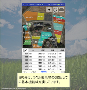
About this app
Z-GIS.a is GIS software that runs on devices running Android 5.0 or higher.
The basic usage is to browse, confirm and modify agricultural GIS data created with Windows version Z-GIS on site.
In addition, you can collect point information on site and perform simple editing.
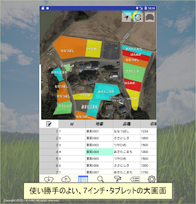
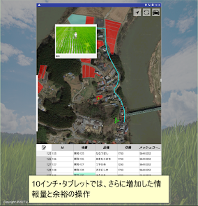
Of course, it can also be used on tablet devices in addition to smartphones.
In addition to basic GIS functions such as displaying geographic information, color coding, and selection, ZGIS.a
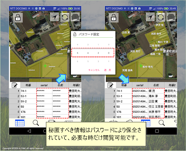
・ Encryption function required for browsing personal information
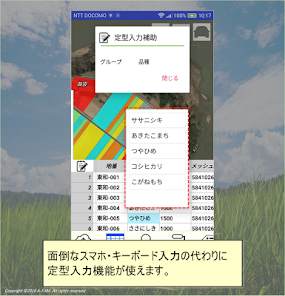
・ Standard input function using template
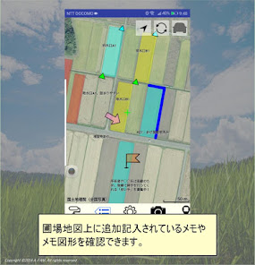
・ In addition to field graphics, display function for graphics and characters added as memos
・ Navigation to the field
It has functions such as.
Please refer to https://z-gis.net for details.
【Notes】
Z-GIS.a has almost the same functions as Z-GIS.i / ii for iOS except for the following.
・ A GIS Excel file created with Z-GIS for Windows can be handled
・ Up to 1,500 fields can be read
・ In addition, due to the performance limitations of the map display engine being used, displaying more than 1,000 polygons may significantly reduce the processing speed.
The basic usage is to browse, confirm and modify agricultural GIS data created with Windows version Z-GIS on site.
In addition, you can collect point information on site and perform simple editing.
Of course, it can also be used on tablet devices in addition to smartphones.
In addition to basic GIS functions such as displaying geographic information, color coding, and selection, ZGIS.a
・ Encryption function required for browsing personal information
・ Standard input function using template
・ In addition to field graphics, display function for graphics and characters added as memos
・ Navigation to the field
It has functions such as.
Please refer to https://z-gis.net for details.
【Notes】
Z-GIS.a has almost the same functions as Z-GIS.i / ii for iOS except for the following.
・ A GIS Excel file created with Z-GIS for Windows can be handled
・ Up to 1,500 fields can be read
・ In addition, due to the performance limitations of the map display engine being used, displaying more than 1,000 polygons may significantly reduce the processing speed.
Updated on
Safety starts with understanding how developers collect and share your data. Data privacy and security practices may vary based on your use, region, and age. The developer provided this information and may update it over time.

This app may share these data types with third parties
Location, Personal info and 2 others

No data collected
Learn more about how developers declare collection

Data is encrypted in transit
What’s new
軽微な修正を行いました。
Everyone
Learn moreApp support
About the developer
NOKYO KYOKAI, GENERAL INC. ASSOCIATION
z-gis@jacom.or.jp
3-1-15, NIHOMBASHININGYOCHO
CHUO-KU, 東京都 103-0013
Japan
+81 3-3639-1121