
GPXSee
1K+
Downloads

Everyone
info
About this app
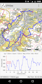
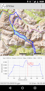
GPXSee is a GPS log file viewer and analyzer that supports all common GPS log file formats.
Key features:
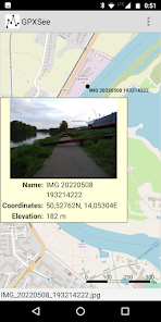
* Opens GPX, TCX, FIT, KML, NMEA, IGC, CUP, SIGMA SLF, Suunto SML, LOC, GeoJSON, OziExplorer (PLT, RTE, WPT), Garmin GPI & CSV, TomTom OV2 & ITN, ONmove OMD/GHP, TwoNav (TRK, RTE, WPT) and geotagged JPEG files.
* User-definable online maps (OpenStreetMap/Google tiles, WMTS, WMS, TMS, QuadTiles).
* Offline maps (OziExplorer maps, TrekBuddy maps/atlases, Garmin IMG/GMAP & JNX maps, TwoNav RMaps, GeoTIFF images, MBTiles, BSB charts, ENC charts, KMZ maps, AlpineQuest maps, Locus/OsmAnd/RMaps SQLite maps, Mapsforge maps, QCT maps, GEMF maps, Osmdroid SQLite maps, Orux maps, World-File georeferenced images).
* Elevation, speed, heart rate, cadence, power, temperature and gear ratio/shifts graphs.
* Support for DEM files (SRTM HGT).
* Support for POI files.
* Export to PNG and PDF.
* Multiple tracks in one view.
* Real-time GPS position.
* Free software (GPLv3 open-source license).
Key features:
* Opens GPX, TCX, FIT, KML, NMEA, IGC, CUP, SIGMA SLF, Suunto SML, LOC, GeoJSON, OziExplorer (PLT, RTE, WPT), Garmin GPI & CSV, TomTom OV2 & ITN, ONmove OMD/GHP, TwoNav (TRK, RTE, WPT) and geotagged JPEG files.
* User-definable online maps (OpenStreetMap/Google tiles, WMTS, WMS, TMS, QuadTiles).
* Offline maps (OziExplorer maps, TrekBuddy maps/atlases, Garmin IMG/GMAP & JNX maps, TwoNav RMaps, GeoTIFF images, MBTiles, BSB charts, ENC charts, KMZ maps, AlpineQuest maps, Locus/OsmAnd/RMaps SQLite maps, Mapsforge maps, QCT maps, GEMF maps, Osmdroid SQLite maps, Orux maps, World-File georeferenced images).
* Elevation, speed, heart rate, cadence, power, temperature and gear ratio/shifts graphs.
* Support for DEM files (SRTM HGT).
* Support for POI files.
* Export to PNG and PDF.
* Multiple tracks in one view.
* Real-time GPS position.
* Free software (GPLv3 open-source license).
Updated on
Safety starts with understanding how developers collect and share your data. Data privacy and security practices may vary based on your use, region, and age. The developer provided this information and may update it over time.

No data shared with third parties
Learn more about how developers declare sharing

No data collected
Learn more about how developers declare collection
What's new
GPXSee 13.22
App support
About the developer
Martin Tůma
tumic@gpxsee.org
Czechia
undefined