
Geoclass Surveying Calculator
Contains ads

3.5star
380 reviews
50K+
Downloads

Everyone
info


About this app
Geoclass Surveying Calculator has powerful tools for surveying, setting out and civil engineering.
Geoclass supports metric and imperial units for distance and area. Coordinate units are in metric and degree.
Using Geoclass you can do:
- Collect points: You can collect points and share the points with UTM Map module. You can also navigate to the points.
- Measure distance, bearing / azimuth from two points.
- Measure angle from 3 points.
- Calculate latitude, longitude or X,Y from coordinate, distance and bearing / azimuth.
- Intersections; forward, line - line and circle by 3 points
- Convert latitude longitude to UTM or vice versa
- Calculate decimal to degree, minute, second
- Stake out latitude and longitude coordinates. Navigate to it from your position with distance label on the map
- Navigate to coordinate from your position on the map
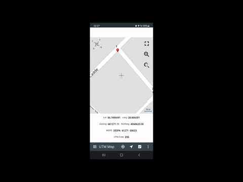
- Display UTM location on online maps with latitude, longitude, MGRS, X,Y coordinates
- Generate coordinates from two points. You can generate using X,Y or latitude, longitude
- Convert local coordinates
- Calculate area from X,Y coordinates
You can follow news about the app on Facebook Page:
fb.me/surveyingcalculator
Geoclass supports metric and imperial units for distance and area. Coordinate units are in metric and degree.
Using Geoclass you can do:
- Collect points: You can collect points and share the points with UTM Map module. You can also navigate to the points.
- Measure distance, bearing / azimuth from two points.
- Measure angle from 3 points.
- Calculate latitude, longitude or X,Y from coordinate, distance and bearing / azimuth.
- Intersections; forward, line - line and circle by 3 points
- Convert latitude longitude to UTM or vice versa
- Calculate decimal to degree, minute, second
- Stake out latitude and longitude coordinates. Navigate to it from your position with distance label on the map
- Navigate to coordinate from your position on the map
- Display UTM location on online maps with latitude, longitude, MGRS, X,Y coordinates
- Generate coordinates from two points. You can generate using X,Y or latitude, longitude
- Convert local coordinates
- Calculate area from X,Y coordinates
You can follow news about the app on Facebook Page:
fb.me/surveyingcalculator
Updated on
Safety starts with understanding how developers collect and share your data. Data privacy and security practices may vary based on your use, region, and age. The developer provided this information and may update it over time.

No data shared with third parties
Learn more about how developers declare sharing

No data collected
Learn more about how developers declare collection
Ratings and reviews
3.5
371 reviews

Taiwo Salam & Co. Properties Limited
- Flag inappropriate
March 25, 2022
Good afternoon, I really enjoying your your app, it's a real blessing for me to come across it. God will continue to enrich your knowledge. I want to ask if you have any solution app on how to convert bearing and distance to plotting? Just the way coordinate can be plot automatically. Or any solution that can do the plotting by starting with coordinate and continue with bearing and distance like you are using Autocad computation for plotting. I will be gad to hear from your team.
45 people found this review helpful
Edip Ahmet Taskin
March 25, 2022
Thank you for your suggestion. I sent you an email about it.

Mutiu Olalekan
- Flag inappropriate
December 6, 2024
The app is very good. There are many changing in this new version which excluded Nigeria minna datum, both utm and ntm conversion for it, it is very essential to make these function available on it , thanks for the knowledge sharing May God increase you knowledge.
15 people found this review helpful
Edip Ahmet Taskin
December 6, 2024
Thank you for your feedback. Previous version of the app had QGIS support. QGIS helped the app to convert Minna datum. New version doesn't have QGIS so I excluded Minna. I hope to include Minna datum for the upcoming updates.

Glenn Reynolds
- Flag inappropriate
July 3, 2022
I create a project in the manage area. Then I go survey and there is Nothing. I can't even get the active layers or the project to show up to start. If they help or fix. I may up the rating...
18 people found this review helpful
What’s new
Added vertical line COGO calculation
App support
About the developer
Edip Ahmet Taşkın
geosoft66@gmail.com
Isfryn House
Ballscott
Hazelhatch
Celbridge
Co. Kildare
W23 D2XF
Ireland
undefined


