South Mountain Reservation Map
100+
Downloads

Everyone
info

About this app
This application shows your GPS position on the hiking map of the South Mountain Reservation. In addition, the application allows you to determine the length of planned hikes, and your location and the direction you are going when on the trail. You can also place multiple markers and copy and input their locations. The application's map is based on a 2020 update of the 2017 topographical map developed by the South Mountain Conservancy showing hiking trails, contour lines, and facilities in the park. The 2,110-acre reservation, originally designed by the Olmsted Brothers, is the largest park in Essex County, NJ. It offers over 50 miles of trails, several picnic areas, and many scenic attractions.
The application offers several useful features for users of Android smartphones:
• Comprehensive, updated multi-colored map. Shows latest trails and signage system.
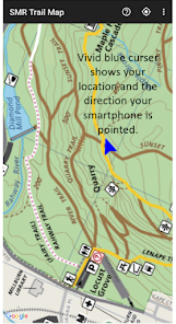
• Answers: Where am I? Which way am I going? Push the centering button to show where you are on the map and the direction you are heading.
• Zoom in on map details and rotate the map. Just like on Google maps, you can easily focus on any specific area and rotate your view.
• Map Cursor.Shows where you are on the map and where you are facing.
• Map Orientation. The application normally has a north-up orientation with north at the top. You can switch to a heading-up orientation that places the direction you are facing at the top of the map.
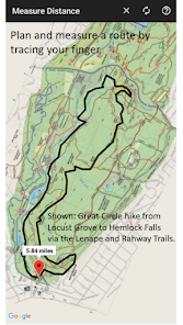
• Measures distances. Tracing your finger or stylus on the map over a possible route provides a track and the distance to 0.01 of a mile.
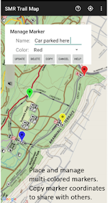
• Place markers on the map. Color code and create names for multiple markers. Place markers from GPS coordinates.
• Output marker coordinates. Mail them to another person to input into their map.
• Needs only a GPS signal. After downloading the map on your phone, the application does not require an internet connection or use data. (Internet connections can be spotty within the park.) If you haven’t used the app in a few days, you may momentarily need an internet connection to re-validate the app license.
• Page-sensitive help. Touch the ? icon for page-specific instructions.
• Pull-down legend. Defines map icons.
• Automatic updates. Updates each year keep the app current as changes in trails, etc., occur, with no additional fee.
• Ad free.
• Compass, gyroscope, and accelerometer are required.You have these sensors if the cursor on your Google Maps application has a direction beam. If these sensors are not present, the map cursor does not show the direction you are facing and heading-up orientation is not supported.
All proceeds from the sale of this application (after paying 30 percent to Google) support the mission of the Conservancy, the non-profit, 501 (c) (3) volunteer-driven organization that serves as a steward of, and advocate for, the Reservation. Go to http://www.somocon.org to see a calendar of hikes and other programs, learn about volunteer opportunities, get on the Conservancy’s mailing list, or become a member. From our online store, you can purchase Dave Hogenauer’s pocket-sized Trail Guide to the SMR that describes the trails and recommended hikes, or see a list of local retail distributors.
The application offers several useful features for users of Android smartphones:
• Comprehensive, updated multi-colored map. Shows latest trails and signage system.
• Answers: Where am I? Which way am I going? Push the centering button to show where you are on the map and the direction you are heading.
• Zoom in on map details and rotate the map. Just like on Google maps, you can easily focus on any specific area and rotate your view.
• Map Cursor.Shows where you are on the map and where you are facing.
• Map Orientation. The application normally has a north-up orientation with north at the top. You can switch to a heading-up orientation that places the direction you are facing at the top of the map.
• Measures distances. Tracing your finger or stylus on the map over a possible route provides a track and the distance to 0.01 of a mile.
• Place markers on the map. Color code and create names for multiple markers. Place markers from GPS coordinates.
• Output marker coordinates. Mail them to another person to input into their map.
• Needs only a GPS signal. After downloading the map on your phone, the application does not require an internet connection or use data. (Internet connections can be spotty within the park.) If you haven’t used the app in a few days, you may momentarily need an internet connection to re-validate the app license.
• Page-sensitive help. Touch the ? icon for page-specific instructions.
• Pull-down legend. Defines map icons.
• Automatic updates. Updates each year keep the app current as changes in trails, etc., occur, with no additional fee.
• Ad free.
• Compass, gyroscope, and accelerometer are required.You have these sensors if the cursor on your Google Maps application has a direction beam. If these sensors are not present, the map cursor does not show the direction you are facing and heading-up orientation is not supported.
All proceeds from the sale of this application (after paying 30 percent to Google) support the mission of the Conservancy, the non-profit, 501 (c) (3) volunteer-driven organization that serves as a steward of, and advocate for, the Reservation. Go to http://www.somocon.org to see a calendar of hikes and other programs, learn about volunteer opportunities, get on the Conservancy’s mailing list, or become a member. From our online store, you can purchase Dave Hogenauer’s pocket-sized Trail Guide to the SMR that describes the trails and recommended hikes, or see a list of local retail distributors.
Updated on
Safety starts with understanding how developers collect and share your data. Data privacy and security practices may vary based on your use, region, and age. The developer provided this information and may update it over time.

No data shared with third parties
Learn more about how developers declare sharing

No data collected
Learn more about how developers declare collection
What's new
Simplify adding markers