
XC Vario | Paragliding Vario

10K+
Downloads

Everyone
info


About this app
The first vario app for paragliding built around the Inertial Measurement Unit (IMU) of your phone offering you a vario with high precision, accuracy and robustness. Cross validation of inertial sensors and the barometer the response of the vario is instant on models like the Pixel 7, 6, 4a and similar equipped phones. Centering thermals will feel more intuitive and natural. A zero lag vario with no thermal missed.
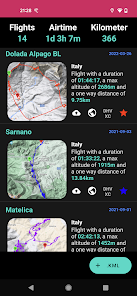
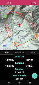
Integrated Flight Book
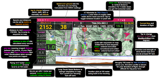
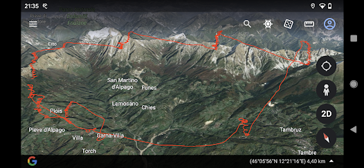
What is an epic xc flight without sharing among other pilot / paragliding buddies, friends or family around the table? Our phone variometer comes with an integrated flight book that keeps all of your flights at your fingertip. You can easily share and analyze your flights from within our vario app, have distances calculated or visualized in google maps and google earth. For xc flying / xc tracks: triangle, three turnpoint and one way distances are calculated continuously in flight.
Customized Vario Sound
With the instant vario technology our phone vario gives you the acoustic feedback at the instant you’re feeling it while paragliding or hang gliding. Entering thermals, centering and finding the core is easily done without any significant delay. You can use predefined sounds and tones or fully customize your own vario sound using vario tone editors for leGpsBip or XCTracer. Setting lift, pre lift and sink tone thresholds is done with no more than a fingertip.
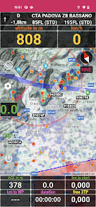
Multiple Altimeter Settings
Our variometer app provide the full range of GNSS and barometric altitudes you come across while xc paragliding or hang gliding cross country including Flight Levels, QNH, QNE or QFE. You can easily set specific altitudes for your current location, start/landing sites or using the integrated lookup from METAR stations. GNSS altitudes (including GPS) such as the mean sea level and the WGS84 altitudes used in .igc files and .kml and for logging are provided as well.
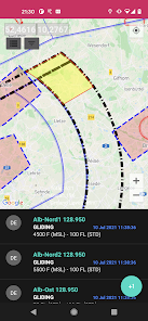
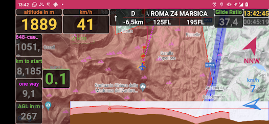
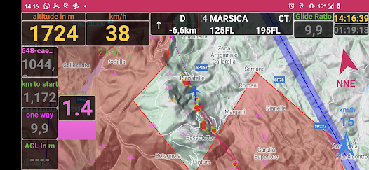
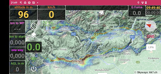
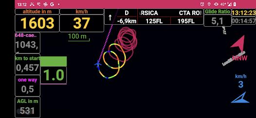
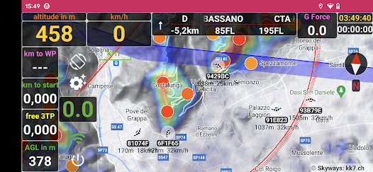
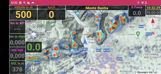
Airspaces and Terrain
Airspaces keep you informed about airspace structure, sectors and flying restrictions being visualized as close as possible to ICAO styling guidelines.
The integrated terrain view can be of use to identify your true direction of flight and to decide if you will arrive with enough altitude crossing that big valley and catch that next thermal and keep on gliding.
Live Tracking
Just turn on instant live tracking to fly with your paragliding buddies and see the latest location, altitude and distance flown so far. No need for extra accounts or signing up procedures. Minimum payload using compression.
GNSS And IGC Logger
Our logger is supporting all global navigation satellite systems including GLONASS, GALILEO, GPS, … . Our logger is precise and accurate using not just GPS but any of the available satellite systems. Logging formats support .kml and .igc files.
Windfinder
Calculating wind direction and speed continuously from GNSS location data. Make a full turn to have a precise calculation.
Bluetooth Vario
And if your phone doesn’t have a barometer. Don’t worry, you can easily connect external varios via bluetooth or usb.
Perfect choice for anyone whether you soar around, cruise along, focus on thermal flying
or try your first xc flights. Suitable as:
* intermediate vario
* everyday vario
* backup vario
As this is an early access beta version feedback is highly appreciated, so get in touch :-)!
Team theFlightVario
Integrated Flight Book
What is an epic xc flight without sharing among other pilot / paragliding buddies, friends or family around the table? Our phone variometer comes with an integrated flight book that keeps all of your flights at your fingertip. You can easily share and analyze your flights from within our vario app, have distances calculated or visualized in google maps and google earth. For xc flying / xc tracks: triangle, three turnpoint and one way distances are calculated continuously in flight.
Customized Vario Sound
With the instant vario technology our phone vario gives you the acoustic feedback at the instant you’re feeling it while paragliding or hang gliding. Entering thermals, centering and finding the core is easily done without any significant delay. You can use predefined sounds and tones or fully customize your own vario sound using vario tone editors for leGpsBip or XCTracer. Setting lift, pre lift and sink tone thresholds is done with no more than a fingertip.
Multiple Altimeter Settings
Our variometer app provide the full range of GNSS and barometric altitudes you come across while xc paragliding or hang gliding cross country including Flight Levels, QNH, QNE or QFE. You can easily set specific altitudes for your current location, start/landing sites or using the integrated lookup from METAR stations. GNSS altitudes (including GPS) such as the mean sea level and the WGS84 altitudes used in .igc files and .kml and for logging are provided as well.
Airspaces and Terrain
Airspaces keep you informed about airspace structure, sectors and flying restrictions being visualized as close as possible to ICAO styling guidelines.
The integrated terrain view can be of use to identify your true direction of flight and to decide if you will arrive with enough altitude crossing that big valley and catch that next thermal and keep on gliding.
Live Tracking
Just turn on instant live tracking to fly with your paragliding buddies and see the latest location, altitude and distance flown so far. No need for extra accounts or signing up procedures. Minimum payload using compression.
GNSS And IGC Logger
Our logger is supporting all global navigation satellite systems including GLONASS, GALILEO, GPS, … . Our logger is precise and accurate using not just GPS but any of the available satellite systems. Logging formats support .kml and .igc files.
Windfinder
Calculating wind direction and speed continuously from GNSS location data. Make a full turn to have a precise calculation.
Bluetooth Vario
And if your phone doesn’t have a barometer. Don’t worry, you can easily connect external varios via bluetooth or usb.
Perfect choice for anyone whether you soar around, cruise along, focus on thermal flying
or try your first xc flights. Suitable as:
* intermediate vario
* everyday vario
* backup vario
As this is an early access beta version feedback is highly appreciated, so get in touch :-)!
Team theFlightVario
Updated on
Safety starts with understanding how developers collect and share your data. Data privacy and security practices may vary based on your use, region, and age. The developer provided this information and may update it over time.

No data shared with third parties
Learn more about how developers declare sharing

This app may collect these data types
Location, Personal info, and Files and docs

Data is encrypted in transit

You can request that data be deleted
What's new
* Dark and Light Themes and many UI adjustments
* In Flight Waypoint Dialog added, activated by tapping the waypoint field. Waypoints / Routes must be activated for this. Stylus Pen recommended.
* Swiss Obstacle Database (BETA). Caution when testing this. Errors will exist.
* Audio Optimizations going for the last microseconds
* Vario Tone Volume and General Volume Settings to customize start up volumes.
* Bug Fixes and Optimizations.
* Intermediate preparations for next release

