
wroSIP mobile
1T+
Downloads

Everyone
info


About this app
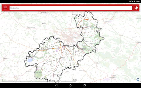
The wroSIP mobile application provides access to spatial data and services from the area of the Wrocław poviat.
This is a mobile version of the online map service wroSIP, built on the basis of the "Agreement on the joint construction of the Spatial Information System Wroclaw Poviat wroSIP" concluded between the Wrocław Poviat and the Communes: Czernica, Długołęka, Jordanów Śląskie, Kątami Wrocławskie, Kobierzyce, Mietkow, Siechnice, Sobótka and Żórawina.
The application allows:
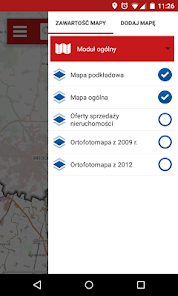
• selection of mapping compositions, by including layers grouped in thematic modules and changing the transparency of layers,
• free navigation on the map (moving, zooming in, zooming out),
• navigating to the current position,
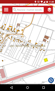
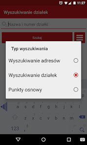
• searching and locating objects, mi. in. through the address, number of the parcel of land,
• adding defined WMS services,
• distance and surface measurement,
• registering the current position along with sending the URL to the map view via email,
• recording the route along with its recording in KML format
This is a mobile version of the online map service wroSIP, built on the basis of the "Agreement on the joint construction of the Spatial Information System Wroclaw Poviat wroSIP" concluded between the Wrocław Poviat and the Communes: Czernica, Długołęka, Jordanów Śląskie, Kątami Wrocławskie, Kobierzyce, Mietkow, Siechnice, Sobótka and Żórawina.
The application allows:
• selection of mapping compositions, by including layers grouped in thematic modules and changing the transparency of layers,
• free navigation on the map (moving, zooming in, zooming out),
• navigating to the current position,
• searching and locating objects, mi. in. through the address, number of the parcel of land,
• adding defined WMS services,
• distance and surface measurement,
• registering the current position along with sending the URL to the map view via email,
• recording the route along with its recording in KML format
Updated on
Safety starts with understanding how developers collect and share your data. Data privacy and security practices may vary based on your use, region and age The developer provided this information and may update it over time.

No data shared with third parties
Learn more about how developers declare sharing

No data collected
Learn more about how developers declare collection

Data is encrypted in transit

Data can’t be deleted