Map Coordinates
Reklamalar mavjudIlova ichida xaridlar
4,3star
27,1 ming ta sharh
5 mln+
Yuklanmalar

Hamma uchun
info


Bu ilova haqida
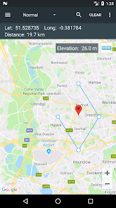
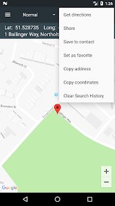
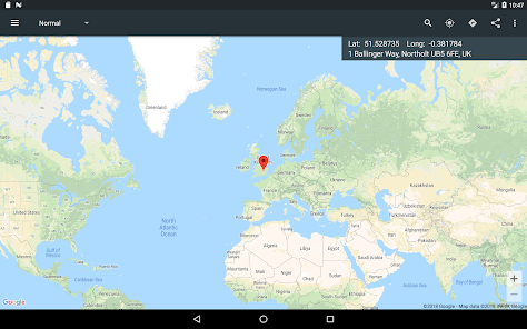
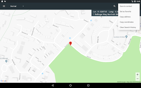
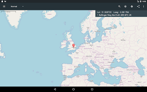
A single tap on the map gives you access to world coordinates. In addition, Map Coordinates offers a full set of tools like distance measurement, current GPS location, history / favorite locations, share location, find location or copy coordinates / address. You can switch between multiple coordinate types like decimal degrees, DMS (degrees, minutes and seconds) or even special types like what3words, MGRS, UTM or GEOREF.
The app is designed to easily determine the coordinates and address of a point on the map and share them with friends via SMS, email or social apps.
When you need to find a location, you can either type / paste the address / coordinates in a search field or enter each coordinate value one by one in it’s own field using the advanced search options. what3words, MGRS, UTM or GEOREF can be searched for only by using the single search field.
The current GPS location is best received while the mobile device is located outdoors. The GPS satellites are easy to be found when there is no interference like buildings or clouds. Even if the device is located indoor, the location can be accurately found through WiFi network but only if the device is connected to that network.
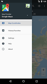
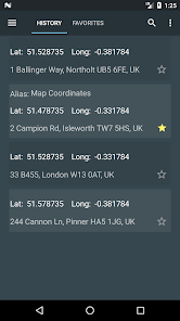
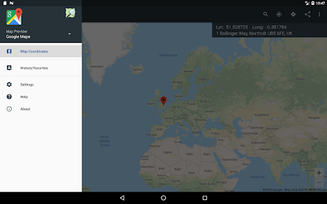
The side drawer menu is used to navigate between different parts of the app like History / Favorites but it is also used to switch the map provider. The available map providers are Google Maps and Open Street Maps, each of them having different map types. Under Open Street Maps there is also a compass available all the time.
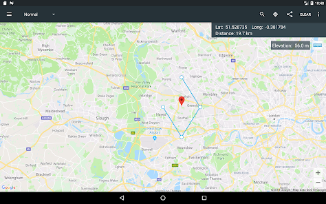
Settings can also be accessed from the side navigation drawer. There you have the options to switch between existing coordinates types, change the visibility of the address bar or you can enable the Distance measure tool and the Elevation tool. Elevation displays the altitude of the selected location on the map.
Notes:
1. GPX and KML file types are supported with certain limits: Only simple waypoints are processed for GPX files and only Placemarks are processed for KML files.
2. UTM, MGRS and GEOREF coordinates types are available as paid options
We hope that this app fulfills your needs but if you have any other expectations, please don’t hesitate to contact us and we will try to help you out.
The app is designed to easily determine the coordinates and address of a point on the map and share them with friends via SMS, email or social apps.
When you need to find a location, you can either type / paste the address / coordinates in a search field or enter each coordinate value one by one in it’s own field using the advanced search options. what3words, MGRS, UTM or GEOREF can be searched for only by using the single search field.
The current GPS location is best received while the mobile device is located outdoors. The GPS satellites are easy to be found when there is no interference like buildings or clouds. Even if the device is located indoor, the location can be accurately found through WiFi network but only if the device is connected to that network.
The side drawer menu is used to navigate between different parts of the app like History / Favorites but it is also used to switch the map provider. The available map providers are Google Maps and Open Street Maps, each of them having different map types. Under Open Street Maps there is also a compass available all the time.
Settings can also be accessed from the side navigation drawer. There you have the options to switch between existing coordinates types, change the visibility of the address bar or you can enable the Distance measure tool and the Elevation tool. Elevation displays the altitude of the selected location on the map.
Notes:
1. GPX and KML file types are supported with certain limits: Only simple waypoints are processed for GPX files and only Placemarks are processed for KML files.
2. UTM, MGRS and GEOREF coordinates types are available as paid options
We hope that this app fulfills your needs but if you have any other expectations, please don’t hesitate to contact us and we will try to help you out.
Oxirgi yangilanish
Xavfsizlik — dastur ishlab chiquvchilar maʼlumotlaringizni qanday jamlashi va ulashishini tushinishdan boshlanadi. Maʼlumotlar maxfiyligi va xavfsizlik amaliyotlari ilovadan foydalanish, hudud va yoshga qarab farq qilishi mumkin. Bu axborot dastur ishlab chiquvchi tomonidan taqdim etilgan va keyinchalik yangilanishi mumkin.

Bu ilova tashqi hamkorlarga quyidagi turdagi maʼlumotlarini ulashishi mumkin
Joylashuv, Ilova tarixi va yana 2 ta

Hech qanday maʼlumot jamlanmagan
Dastur ishlab chiquvchilar axborot jamlanishini qanday aytishi haqida batafsil

Maʼlumotlar shifrlanmagan
Maʼlumotlar oʻchmaydi
Reytinglar va sharhlar
4,4
25,5 ming ta sharh

Baxtiniso Hasanova
- Nomaqbul deb belgilash
12-oktabr, 2023
Zoʻr
1 kishi bu sharhni foydali deb topgan

Rasul Xolboyev
- Nomaqbul deb belgilash
9-iyun, 2021
Yaxshi ilova ekan tavsiya qilaman
2 kishi bu sharhni foydali deb topgan

Messi Messi 10
- Nomaqbul deb belgilash
13-dekabr, 2022
Endi tortdim pizdes ekan tavsiya qilaman


