Grafväder

Everyone
info
100+
Downloads

Everyone
Learn more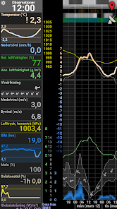
About this app
The app can display weather forecasts, observed measurements, radar and lightning films and weather warnings, all based on data from SMHI. It is completely free of suns, snowflakes and advertising.
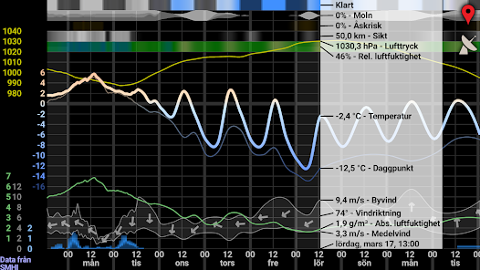
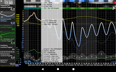
Weather forecast:
Interactive diagram with the following weather parameters:
- Sky appearance based on general weather type and sun position (dawn, day, dusk or night).
- Cloudiness in three height levels.
- Thunderstorm risk.
- Visibility.
- Relative humidity.
- Precipitation risk and snow percentage.
- Air pressure.
- Temperature.
- Dew point.
- Absolute humidity.
- Average wind, gust and wind direction.
- Precipitation with levels for min, median and max value. (The color of the precipitation bars is strongest up to the min value, then weaker to the median value and even weaker to the max value. The color also gradually changes from blue to white as the proportion of snow in the precipitation increases. The latter also applies to the risk of precipitation.)
- Weather warnings in the form of a warning triangle that can be pressed. Its color indicates the warning level. (Only displayed if there are warnings for the location you have selected.)
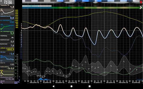
Weather observations:
For each parameter, the latest measured hourly value from the nearest weather station within 100 km is displayed. An exclamation mark in front of the value indicates that there is another station that is closer, but that does not have a current value. The text "-1h" in front of the value indicates that it is one hour old, as no station within 100 km has a current value.
The graphs show the development of the respective parameter over the last 24 hours. Gaps indicate missing data.
The following measured values can be displayed:
- Temperature.
- Precipitation.
- Relative humidity.
- Absolute humidity.
- Wind direction.
- Mean wind.
- Gust.
- Air pressure.
- Visibility.
- Cloudiness.
- Sunshine hours.
- Global radiation.
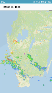
Radar (precipitation), lightning and weather warning areas:
Shows a radar film of images taken every 5 minutes for the last 8 hours. The film starts immediately with the newest images. Older images are loaded continuously and make the film longer (starts earlier) until all 8 hours have been loaded.
Lightning strikes for the next 5 minutes are shown on each image. (However, the last radar image shows all subsequent lightning strikes, which may mean that the period is a little longer than 5 minutes.)
The map also shows any weather warnings in the form of areas in different colors depending on the warning level. Long press on areas to see warning texts.
Features:
- Tap the red symbol at the top right to change the selected location.
- Forecast: Rotate the device or drag the forecast to change the displayed forecast length.
- Forecast: Tap anywhere on the forecast to display values for a specific time.
- Observations: Tap an observed value to show/hide a graph.
- Observations: Tap the "Observations" heading to change the displayed parameter information.
- Observations: Swipe left or right on the left side to show or hide the observations.
- Radar: Tap the radar icon at the top right to display a radar movie.
- Radar: Tap anywhere to stop/start the movie.
- Radar: When the movie is stopped, swipe right/left to change the displayed time.
- Weather warnings: If there are weather warnings for your location, a triangle will appear on the main page. Tap it to see the warning texts.
The app works just as well on mobile as on tablet.
Icon designer: Lardalot
Weather forecast:
Interactive diagram with the following weather parameters:
- Sky appearance based on general weather type and sun position (dawn, day, dusk or night).
- Cloudiness in three height levels.
- Thunderstorm risk.
- Visibility.
- Relative humidity.
- Precipitation risk and snow percentage.
- Air pressure.
- Temperature.
- Dew point.
- Absolute humidity.
- Average wind, gust and wind direction.
- Precipitation with levels for min, median and max value. (The color of the precipitation bars is strongest up to the min value, then weaker to the median value and even weaker to the max value. The color also gradually changes from blue to white as the proportion of snow in the precipitation increases. The latter also applies to the risk of precipitation.)
- Weather warnings in the form of a warning triangle that can be pressed. Its color indicates the warning level. (Only displayed if there are warnings for the location you have selected.)
Weather observations:
For each parameter, the latest measured hourly value from the nearest weather station within 100 km is displayed. An exclamation mark in front of the value indicates that there is another station that is closer, but that does not have a current value. The text "-1h" in front of the value indicates that it is one hour old, as no station within 100 km has a current value.
The graphs show the development of the respective parameter over the last 24 hours. Gaps indicate missing data.
The following measured values can be displayed:
- Temperature.
- Precipitation.
- Relative humidity.
- Absolute humidity.
- Wind direction.
- Mean wind.
- Gust.
- Air pressure.
- Visibility.
- Cloudiness.
- Sunshine hours.
- Global radiation.
Radar (precipitation), lightning and weather warning areas:
Shows a radar film of images taken every 5 minutes for the last 8 hours. The film starts immediately with the newest images. Older images are loaded continuously and make the film longer (starts earlier) until all 8 hours have been loaded.
Lightning strikes for the next 5 minutes are shown on each image. (However, the last radar image shows all subsequent lightning strikes, which may mean that the period is a little longer than 5 minutes.)
The map also shows any weather warnings in the form of areas in different colors depending on the warning level. Long press on areas to see warning texts.
Features:
- Tap the red symbol at the top right to change the selected location.
- Forecast: Rotate the device or drag the forecast to change the displayed forecast length.
- Forecast: Tap anywhere on the forecast to display values for a specific time.
- Observations: Tap an observed value to show/hide a graph.
- Observations: Tap the "Observations" heading to change the displayed parameter information.
- Observations: Swipe left or right on the left side to show or hide the observations.
- Radar: Tap the radar icon at the top right to display a radar movie.
- Radar: Tap anywhere to stop/start the movie.
- Radar: When the movie is stopped, swipe right/left to change the displayed time.
- Weather warnings: If there are weather warnings for your location, a triangle will appear on the main page. Tap it to see the warning texts.
The app works just as well on mobile as on tablet.
Icon designer: Lardalot
Updated on
Safety starts with understanding how developers collect and share your data. Data privacy and security practices may vary based on your use, region, and age. The developer provided this information and may update it over time.

No data shared with third parties
Learn more about how developers declare sharing

This app may collect these data types
App activity, App info and performance, and Device or other IDs

Data is encrypted in transit

Data can’t be deleted
What’s new
Version 2.11 (2026-04-05)
- Nederbördsmängden visas nu igen korrekt som mm/h.
Version 2.10 (2026-04-02)
- Gick över till SMHI's nya prognos-API.
- Lade till ny prognosparameter: Nederbördsrisk.
Version 2.9 (2026-03-01)
- Se vädervarningar för vald plats via varningstriangel, samt alla i radarvyn.
- Radarfilmen startar nu direkt och laddar under tiden mer bakåt i tiden.
Everyone
Learn moreApp support
About the developer
Thalin Gunnar
apps@guthspot.se
Sweden