
しおさい-潮見表/天気予報
Contains ads
100K+
Downloads

Everyone
info


About this app
It is a free app that displays the tide information of Japan.
Tidal and weather (temperature, rain, wind) will support the anxious "you".
Operation is also easy!
Quickly want information!
Information other than the tide is also compact in a single screen!
· [Weather] weather information of every 3 hours up to five days watch
And checking [alarm] Meteorological Agency weather alert is announced at the same time
· [Terrain] from the wind direction / wind speed and map terrain to ally
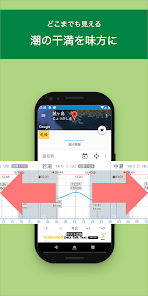
You can also register your "favorite" point.
It provides weather, weather information in accordance with the point.
■ Main display data
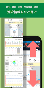
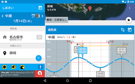
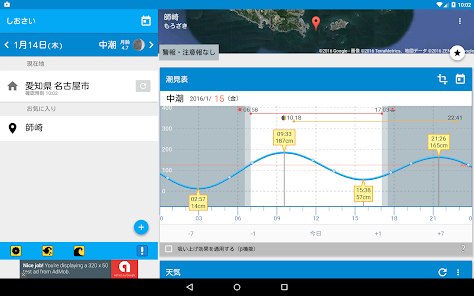
(1) tidal information
Tide graph (tide table-tide tables), tide, tide name, tide
(2) Weather forecast
Temperature, humidity, clouds, precipitation, wind direction and wind speed, atmospheric pressure
(3) months of age / moonlight
(4) sunrise / day input
(5) Tsukide / month input
(6) Japan Meteorological Agency announced data
Weather warning and advisory
■ β function (beta)
Lower than around atmospheric pressure at the center of a typhoon or cyclone, the air around the high pressure down on the sea, as a result of air near the center acts to suck seawater, sea level will rise. When the pressure drops 1 hectopascals (hPa), the tide level is said to rise about 1 centimeter. In this application program it has been calculated from past weather data of the Japan Meteorological Agency.
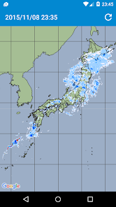
Japan Meteorological Agency to analyze and predict the distribution of the precipitation area with a high resolution is a "high-resolution precipitation nowcasting".
In addition to the data of the weather Doppler radar, observation data of the Japan Meteorological Agency, the Ministry of Land, Infrastructure and Transport and local governments are held across the country about 10,000 locations rain gauge of the high-rise observation data of wind profiler and radio sonde, the data of the Ministry of Land, Infrastructure and Transport XRAIN leverage, the inside of the precipitation area has a three-dimensional analysis.
■ Note · Disclaimer
- acquiring position information in the present application, also retains its history, use for the purpose of providing a function or information suitable for customers (including advertising)
- it is not available to the voyage
Trouble and accidents caused by using this app does not take any responsibility
Tidal and weather (temperature, rain, wind) will support the anxious "you".
Operation is also easy!
Quickly want information!
Information other than the tide is also compact in a single screen!
· [Weather] weather information of every 3 hours up to five days watch
And checking [alarm] Meteorological Agency weather alert is announced at the same time
· [Terrain] from the wind direction / wind speed and map terrain to ally
You can also register your "favorite" point.
It provides weather, weather information in accordance with the point.
■ Main display data
(1) tidal information
Tide graph (tide table-tide tables), tide, tide name, tide
(2) Weather forecast
Temperature, humidity, clouds, precipitation, wind direction and wind speed, atmospheric pressure
(3) months of age / moonlight
(4) sunrise / day input
(5) Tsukide / month input
(6) Japan Meteorological Agency announced data
Weather warning and advisory
■ β function (beta)
Lower than around atmospheric pressure at the center of a typhoon or cyclone, the air around the high pressure down on the sea, as a result of air near the center acts to suck seawater, sea level will rise. When the pressure drops 1 hectopascals (hPa), the tide level is said to rise about 1 centimeter. In this application program it has been calculated from past weather data of the Japan Meteorological Agency.
Japan Meteorological Agency to analyze and predict the distribution of the precipitation area with a high resolution is a "high-resolution precipitation nowcasting".
In addition to the data of the weather Doppler radar, observation data of the Japan Meteorological Agency, the Ministry of Land, Infrastructure and Transport and local governments are held across the country about 10,000 locations rain gauge of the high-rise observation data of wind profiler and radio sonde, the data of the Ministry of Land, Infrastructure and Transport XRAIN leverage, the inside of the precipitation area has a three-dimensional analysis.
■ Note · Disclaimer
- acquiring position information in the present application, also retains its history, use for the purpose of providing a function or information suitable for customers (including advertising)
- it is not available to the voyage
Trouble and accidents caused by using this app does not take any responsibility
Updated on
Safety starts with understanding how developers collect and share your data. Data privacy and security practices may vary based on your use, region, and age. The developer provided this information and may update it over time.


What's new
アプリの運営費を安定的に確保するため、広告表示比率やリワードの頻度を変更させていただくことになりました