
Live PID
Contains adsIn-app purchases

Everyone
info
10K+
Downloads

Everyone
Learn more


About this app
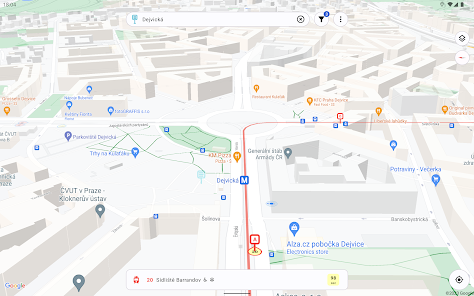
The app displays live vehicle positions and all stops of the Prague Integrated Transport (PID) network directly on the map. You can add stops, lines, or individual vehicles to favorites for quick access.
Using the location button, you can follow your own position or track a specific vehicle in real time. The map supports multiple layers and offers additional options such as traffic density and 3D buildings.
Filter
The app includes advanced filters that allow you to:
• filter stops by type
• filter vehicles by type
• show only vehicles with air conditioning
• show only wheelchair-accessible vehicles
• show only vehicles currently in service
• favorite stops and vehicles are always displayed on the map regardless of the active filters.
Stop detail
Each stop has a detailed view showing:
• exact positions of individual platforms
• metro entrance locations (for metro stations)
• below the map, you’ll find a departure board that can be filtered by platform.
Vehicle detail
The vehicle detail screen includes:
• a map with the exact route and all stops of the line
• a detailed timetable with optional real-time updates
• a timeline showing the current vehicle position
• vehicle details and a photo (if available)
• for trains: coach composition (if available)
• for trains: display of passing points where the train does not stop
Search
All stops and vehicles can be searched from a dedicated search screen. The search supports:
• stop and line names
• vehicle registration numbers
• train numbers
• vehicle run (circulations)
Updated on
Safety starts with understanding how developers collect and share your data. Data privacy and security practices may vary based on your use, region, and age. The developer provided this information and may update it over time.

No data shared with third parties
Learn more about how developers declare sharing

No data collected
Learn more about how developers declare collection

Committed to follow the Play Families Policy
What’s new
• app rebranding
• subscription with premium features
• improved search functionality
• list of platforms in stop details
• ability to add to favorites from stop or route details
• subscription with premium features
• improved search functionality
• list of platforms in stop details
• ability to add to favorites from stop or route details
Everyone
Learn moreApp support
About the developer
Appline s. r. o.
hello@appline.sk
Matice Slovenskej 497/32
082 21 Veľký Šariš
Slovakia
+421 949 486 104