
Map Canvas: Draw Shapes On Map
Contains adsIn-app purchases
star
22 reviews

Everyone
info
1K+
Downloads

Everyone
Learn more




About this app
Draw circles, radius rings, polygons and markers on any map — then measure the area inside them in acres, hectares, square miles or square kilometres.
Map Canvas turns Google Maps into a canvas you can draw on. Drop a radius circle around any point, trace a polygon around a field or property, and save it all with notes, tasks and photos attached. Switch to satellite or terrain view to trace boundaries you can see.
Checking how far a delivery zone reaches, measuring a paddock in acres, or working out what falls within a mile of a new house — the tools are in one place.
DRAW ON THE MAP
• Radius Circles — Set an exact radius in kilometres, miles or feet and drop a circle anywhere. Build concentric circle groups to compare several distances from one centre point at once.
• Custom Polygons — Trace any multi-sided shape around a field, plot, property or zone by tapping points on the map. Drag any vertex to fine-tune the outline.
• Icon Markers — Hundreds of icons across farming, travel, food, flora and fauna to mark equipment, landmarks, wells, gates or stands.
• Styling — Adjust main colour, fill colour, stroke width and visibility on every element.
MEASURE LAND AREA AND DISTANCE
• Area Calculation — Every circle and polygon shows its enclosed area automatically, in square kilometres and hectares or square miles and acres.
• Distance Measurement — Measure point-to-point distances for route estimates, fence runs and layout planning.
• Metric or Imperial — Switch unit systems any time.
• Coordinates — Tap any element for its exact latitude and longitude.
ORGANISE YOUR WORK
• Notes — Name every shape, circle and marker and add a description and notes.
• Tasks — Attach a task list to any element and tick items off as work gets done in the field.
• Photos — Attach images so site conditions, crops or progress stay tied to the spot.
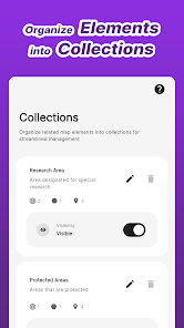
• Collections — Group related shapes and markers, then toggle a whole Collection on or off at once.
MAP AND APP OPTIONS
• Map Types — Normal, terrain, or hybrid satellite imagery for tracing real boundaries, treelines and field edges.
• Map Styles — Day, night and retro.
• Address Search — Jump to any address or place name.
• Weather — Current conditions for any marked location.
• Themes — Light or dark, metric or imperial, 12h or 24h.
• Cloud Backup — Back up map data securely (200 MB) and restore on a new device.
WHO USES MAP CANVAS
• Farmers measuring fields in acres or hectares and planning irrigation by plot
• Real estate agents and buyers checking property size and what sits within a radius of a listing
• Land owners marking boundaries, fence lines and access points
• Hunters, anglers and hikers marking stands, blinds, trails, camps and access routes
• Delivery, courier and service businesses mapping coverage zones and travel radius
• Truck and cargo drivers visualising air-mile radius limits and travel perimeters
• Landscapers, roofers, solar installers and contractors sizing jobs before quoting
• Construction teams marking staging areas and exclusion zones
• Urban planners and architects annotating zones and development sites
• Researchers and ecologists recording habitats and survey plots
• Event organisers laying out stages, parking and checkpoints
• Students and GIS learners exploring geography, distance and scale
IMPORTANT
Map Canvas is a map annotation and estimation tool, not a survey-grade instrument. Distances and areas are approximations and are no substitute for professional surveying, legal boundary determination or navigation. There are no turn-by-turn directions.
FREE AND PRO
Free lets you draw single circles, custom shapes and basic markers, search addresses and add notes. Pro removes ads and unlocks concentric circle groups, premium icons, Collections, distance measurement, tasks, photos and map themes. Pro+ adds cloud backup and weather.
Set a radius, measure an area, mark what matters — and keep every note, task and photo attached to the place it belongs.
Map Canvas turns Google Maps into a canvas you can draw on. Drop a radius circle around any point, trace a polygon around a field or property, and save it all with notes, tasks and photos attached. Switch to satellite or terrain view to trace boundaries you can see.
Checking how far a delivery zone reaches, measuring a paddock in acres, or working out what falls within a mile of a new house — the tools are in one place.
DRAW ON THE MAP
• Radius Circles — Set an exact radius in kilometres, miles or feet and drop a circle anywhere. Build concentric circle groups to compare several distances from one centre point at once.
• Custom Polygons — Trace any multi-sided shape around a field, plot, property or zone by tapping points on the map. Drag any vertex to fine-tune the outline.
• Icon Markers — Hundreds of icons across farming, travel, food, flora and fauna to mark equipment, landmarks, wells, gates or stands.
• Styling — Adjust main colour, fill colour, stroke width and visibility on every element.
MEASURE LAND AREA AND DISTANCE
• Area Calculation — Every circle and polygon shows its enclosed area automatically, in square kilometres and hectares or square miles and acres.
• Distance Measurement — Measure point-to-point distances for route estimates, fence runs and layout planning.
• Metric or Imperial — Switch unit systems any time.
• Coordinates — Tap any element for its exact latitude and longitude.
ORGANISE YOUR WORK
• Notes — Name every shape, circle and marker and add a description and notes.
• Tasks — Attach a task list to any element and tick items off as work gets done in the field.
• Photos — Attach images so site conditions, crops or progress stay tied to the spot.
• Collections — Group related shapes and markers, then toggle a whole Collection on or off at once.
MAP AND APP OPTIONS
• Map Types — Normal, terrain, or hybrid satellite imagery for tracing real boundaries, treelines and field edges.
• Map Styles — Day, night and retro.
• Address Search — Jump to any address or place name.
• Weather — Current conditions for any marked location.
• Themes — Light or dark, metric or imperial, 12h or 24h.
• Cloud Backup — Back up map data securely (200 MB) and restore on a new device.
WHO USES MAP CANVAS
• Farmers measuring fields in acres or hectares and planning irrigation by plot
• Real estate agents and buyers checking property size and what sits within a radius of a listing
• Land owners marking boundaries, fence lines and access points
• Hunters, anglers and hikers marking stands, blinds, trails, camps and access routes
• Delivery, courier and service businesses mapping coverage zones and travel radius
• Truck and cargo drivers visualising air-mile radius limits and travel perimeters
• Landscapers, roofers, solar installers and contractors sizing jobs before quoting
• Construction teams marking staging areas and exclusion zones
• Urban planners and architects annotating zones and development sites
• Researchers and ecologists recording habitats and survey plots
• Event organisers laying out stages, parking and checkpoints
• Students and GIS learners exploring geography, distance and scale
IMPORTANT
Map Canvas is a map annotation and estimation tool, not a survey-grade instrument. Distances and areas are approximations and are no substitute for professional surveying, legal boundary determination or navigation. There are no turn-by-turn directions.
FREE AND PRO
Free lets you draw single circles, custom shapes and basic markers, search addresses and add notes. Pro removes ads and unlocks concentric circle groups, premium icons, Collections, distance measurement, tasks, photos and map themes. Pro+ adds cloud backup and weather.
Set a radius, measure an area, mark what matters — and keep every note, task and photo attached to the place it belongs.
Draw radius circles, polygons & markers on map. Measure land area & distance.
Updated on
Safety starts with understanding how developers collect and share your data. Data privacy and security practices may vary based on your use, region, and age. The developer provided this information and may update it over time.
- No data shared with third partiesLearn more about how developers declare sharing
- This app may collect these data typesPersonal info
- Data is encrypted in transit
- You can request that data be deleted


Ratings and reviews
20 reviews

Thomas Doherty
- Flag inappropriate
September 5, 2026
Excellent… keep up the good work… thank you!

Ralph Hashoian
- Flag inappropriate
June 20, 2025
nice app, use it to measure rough square area in a real estate application. The original rev of the app gave area in only square miles. Not real convenient for small lots. Contacted the developer Colored Pixels Studio and they got right back to me and increased resolution so I could see smaller square miles. Pretty responsive! Just today I got a notification they modified the area to show acres and hectares. Very nice Went out and bought the Pro version!

Raj k
- Flag inappropriate
June 15, 2025
Simple and effective. Was super useful for my house hunting, as I need to stay within 25 miles of my office due to work-from-office policy. Also use it to plan calculated stops for my evening walks or runs.
What’s new
Bug fixes and UI Improvements
Everyone
Learn moreApp support
About the developer
Hrishikesh Dattatraya Deshkar
hellocoloredpixelsstudio@gmail.com
310 10th St
Jersey City, NJ 07302-1678
United States


