
Hurricane & Typhoon Track
Contains ads
3.8star
471 reviews
100K+
Downloads

Everyone
info


About this app
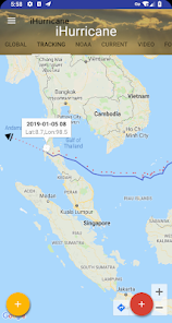
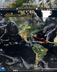
Hurricane & Typhoon Track allows you to keep track of tropical storm ,Typhoon,and hurricane activity in the Global Ocean basins. gives you the most up to the minute and reliable hurricane & Typhoon path,Tracking Map,coordinates data,Satellite Images, Computer Models,Warning Information and high resolution Satellite maps... with data provided by 22,000+ trusted or official weather stations all over the world.
Also, you will be able to stay informed on the status of the local and national power grid and surge probability.
Here are the key highlights of this application...
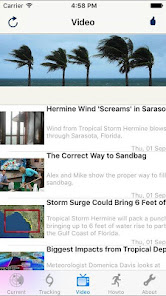
* Quick overview of active hurricanes, tropical storms, depressions, and other cyclones
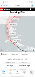
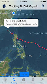
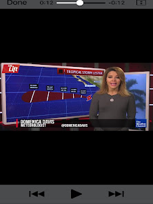
* Get real-time Hurricane & Typhoon Tracking
* Emergency Shelters
* Tap on any map to view full screen, with pinch-to-zoom, drag, and scroll support, even during loop playback
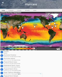
* Current Storm Location
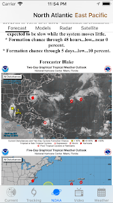
* Computer Models
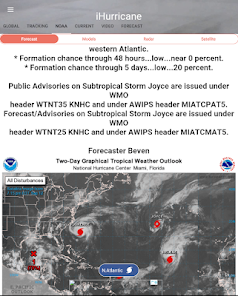
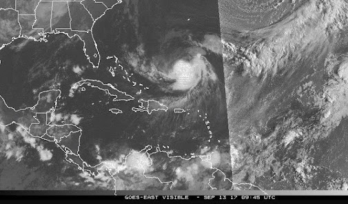
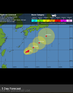
* Forecast cones (5-day uncertainty track), wind speed probability, storm surge maps (when available), and GOES Floater satellite imagery
* Storm Surge Probability
* Optional Forecast Model Viewer Add-On: View forecast models (also known as spag models) for active systems on an interactive map complete with panning, zooming, and individual model point information when tapped. Features selectable models, start time, and run length
* Sharing of screenshots with any app that supports it (Facebook, Twitter, etc.)
* Multiple types of regional summary maps and satellite loops to choose from (full list below)
* Road Maps
* Historical Map
* Per-storm advisory & discussion text from the experts at the National Hurricane Center, Public & Marin Advisory
**************************************
all the data is just from National Oceanic and Atmospheric Administration, (NOAA)
Stay informed about the latest tropical systems in the Atlantic,Pacific,Indian Ocean and Caribbean . Get the most recent maps and forecast details about active storms.
Also, you will be able to stay informed on the status of the local and national power grid and surge probability.
Here are the key highlights of this application...
* Quick overview of active hurricanes, tropical storms, depressions, and other cyclones
* Get real-time Hurricane & Typhoon Tracking
* Emergency Shelters
* Tap on any map to view full screen, with pinch-to-zoom, drag, and scroll support, even during loop playback
* Current Storm Location
* Computer Models
* Forecast cones (5-day uncertainty track), wind speed probability, storm surge maps (when available), and GOES Floater satellite imagery
* Storm Surge Probability
* Optional Forecast Model Viewer Add-On: View forecast models (also known as spag models) for active systems on an interactive map complete with panning, zooming, and individual model point information when tapped. Features selectable models, start time, and run length
* Sharing of screenshots with any app that supports it (Facebook, Twitter, etc.)
* Multiple types of regional summary maps and satellite loops to choose from (full list below)
* Road Maps
* Historical Map
* Per-storm advisory & discussion text from the experts at the National Hurricane Center, Public & Marin Advisory
**************************************
all the data is just from National Oceanic and Atmospheric Administration, (NOAA)
Stay informed about the latest tropical systems in the Atlantic,Pacific,Indian Ocean and Caribbean . Get the most recent maps and forecast details about active storms.
Updated on
Safety starts with understanding how developers collect and share your data. Data privacy and security practices may vary based on your use, region, and age. The developer provided this information and may update it over time.

This app may share these data types with third parties
Location and Device or other IDs

No data collected
Learn more about how developers declare collection

Data is encrypted in transit

Data can’t be deleted
Ratings and reviews
3.7
449 reviews

Byron Jackson
- Flag inappropriate
December 19, 2020
Ads were painfully loud and intrusive. I don't want ads about excrement to be blasted all over the bus I am on. Turns me OFF buying the paid version Could NOT get it to show predictions for anywhere but America, couldn't get it to show projected track for Yasa. It took 2 or 3 goes to get it to start on my phone so I re installed it and and now won't run at all. Pity it might have had potential.
14 people found this review helpful

Steve Gottula
- Flag inappropriate
September 6, 2023
Way too many ads. Everytime I try to access a feature, an ad pops up and then no storm info.

Pertwee
- Flag inappropriate
June 2, 2022
Quit telling me to update. I have and have even Uninstalled/reinstalled. Message says app has a bug!
4 people found this review helpful
What's new
bug fix