Red Transporte DF PRO
4.8star
91 reviews
500+
Downloads

Everyone
info
About this app
WHY USE "DF TRANSPORT NETWORK PRO"?
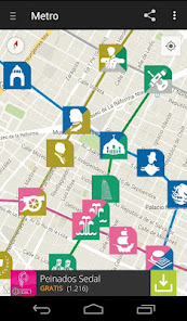
Since its launch in August 2012 until today, we have the most information and the best features to publicize the routes, lines, stations and maps of the public transport system in Mexico City and Metropolitan Area.
We are the best application in terms of urban mobility, since there is currently no open database so complete, functional, updated and nice design that provides help to users.
Today, more than 59 are updates that have led us to improve and grow as a project 100% Mexican, to provide the best utility, saving battery, mobile data and storage space on your smartphone.
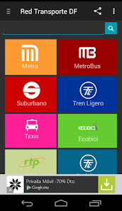
INCLUDED IN TRANSPORT SYSTEMS:
• Meter
• Metrobus
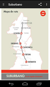
• Suburbano
• Light Rail
• Cab
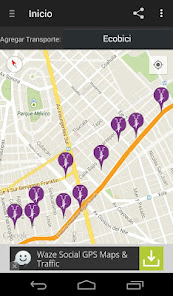
• ECOBICI
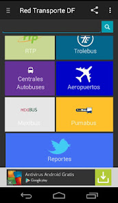
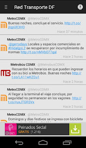
• RTP
• Trolleybus
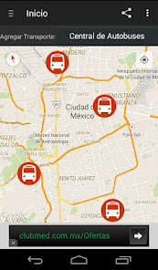
• Central Bus
• Airports
• Mexibus
• PumaBús
• Reports through social networks.
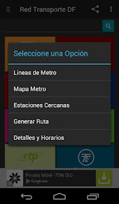
KEY FEATURES:
• Transport Lines
• Maps
• Neighborhood Maps
• Displays on Google Maps
• Nearby Stations
• Generate Route Multimodal
• Details and Schedule
• Cost
• Estimated time
• Length of the trail
• Stations to go
• Transhipment to go
• Approximate Location
• Exact location GPS
• Offline (works without Internet connection)
• Languages
• SD Memory Installation
CURRENT VERSIONS:
For nearly over 2 years, the application was completely free, however, we are committed to continue generating new products for you and now with this version free PRO advertising at low cost, will be your biggest investment and your smarter purchase.
Let us know what you think below ... you can rate, comment and review !!
Do you love Red Transport DF app?
Dale "Like" on Facebook: https://www.facebook.com/Curisteando
Follow us on Twitter: https://twitter.com/curisteando
Since its launch in August 2012 until today, we have the most information and the best features to publicize the routes, lines, stations and maps of the public transport system in Mexico City and Metropolitan Area.
We are the best application in terms of urban mobility, since there is currently no open database so complete, functional, updated and nice design that provides help to users.
Today, more than 59 are updates that have led us to improve and grow as a project 100% Mexican, to provide the best utility, saving battery, mobile data and storage space on your smartphone.
INCLUDED IN TRANSPORT SYSTEMS:
• Meter
• Metrobus
• Suburbano
• Light Rail
• Cab
• ECOBICI
• RTP
• Trolleybus
• Central Bus
• Airports
• Mexibus
• PumaBús
• Reports through social networks.
KEY FEATURES:
• Transport Lines
• Maps
• Neighborhood Maps
• Displays on Google Maps
• Nearby Stations
• Generate Route Multimodal
• Details and Schedule
• Cost
• Estimated time
• Length of the trail
• Stations to go
• Transhipment to go
• Approximate Location
• Exact location GPS
• Offline (works without Internet connection)
• Languages
• SD Memory Installation
CURRENT VERSIONS:
For nearly over 2 years, the application was completely free, however, we are committed to continue generating new products for you and now with this version free PRO advertising at low cost, will be your biggest investment and your smarter purchase.
Let us know what you think below ... you can rate, comment and review !!
Do you love Red Transport DF app?
Dale "Like" on Facebook: https://www.facebook.com/Curisteando
Follow us on Twitter: https://twitter.com/curisteando
Updated on
Safety starts with understanding how developers collect and share your data. Data privacy and security practices may vary based on your use, region and age The developer provided this information and may update it over time.

No data shared with third parties
Learn more about how developers declare sharing

No data collected
Learn more about how developers declare collection

Data is encrypted in transit

Data can’t be deleted
Ratings and reviews
4.8
91 reviews

Nina Castro
- Flag inappropriate
- Show review history
08 October 2020
Compré la versión pro para ver si crasheaba menos, y no... Crashea a cada rato, no me deja calcular mis rutas. Nada. ¿Qué puedo hacer? Update, volví a descargarla pero no carga nada. Se queda en loading.
capi
08 October 2020
Hola, rehice la app desde 0 agregando mas tipos de transporte, haciendola más tolerante a fallos y rapida, actualizala y dejanos saber tus comentarios. Gracias!
What's new
Agregamos línea 1 Express del Mexibus.
Agregamos línea Verde del Cablebus.
Agregamos línea Trolebus elevado.
Actualización de nombres de estaciones.
Información y horarios del servicio para Trolebuses.
Se agrega sitios web a la información del servicio.
Optimización en iconos genericos ahora muestran todas las intersecciones de lineas.
Optimización de recursos de la app.
App support
phone
Phone number
+525529002567