
Ocean Tools: Marine Science
Contains ads
100+
Downloads

Everyone
info
About this app
The aim of the "Ocean Tools: Marine Science" app is to develop useful tools for use in the planning and development of oceanographic surveys. It is not about providing tools that perform large calculations or processing, but rather Ocean Tools is focused on algorithms to perform small calculations on a day-to-day basis during the planning and execution of oceanographic campaigns.
The tools will be implemented little by little, so keep an eye out for updates as they are released.
If you have an idea for a tool that you consider helpful or would like us to add a specific tool, don't hesitate to get in touch with us at didymeapps@gmail.com. Please explain your idea in detail.
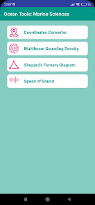
For now, the tools available on the "Ocean Tools: Marine Science" app are:
1.- Coordinates Converter: This tool permits the user to convert latitude and longitude between decimal degrees, degrees and minutes, and degrees, minutes, and seconds. Also, we have added the conversion from Decimal degree coordinates to UTM (Universal Tranverse Mercator) and from UTM coordinates to Decimal Degree. The point is shown on a map.
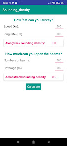
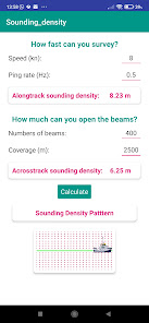
2. .- Multibeam Sounding density: It calculates the spatial resolution or density of soundings using a multibeam echosounder. Along-track and across-track densities depend on vessel speed, ping rate, number of beams and coverage.
Also, this app incorporates a distance calculator for a parallel multibeam echo sounder line with a user-specified overlap percentage.
3.- Shepard's Ternary Diagram: Based on the proportions of sand-, silt- and clay-sized particles, the bottom sediments are classified according to Shepard's diagram. Each sediment sample plots as a point within or along the sides of the diagram, depending on its specific grain size composition.
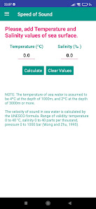
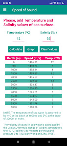
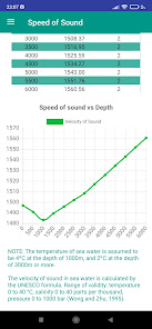
4. Sound velocity calculator: Calculates the velocity of sound in seawater and draws the chart. The Velocity of sound in sea-water changes with water pressure, temperature, and salinity. It is calculated by UNESCO formula.
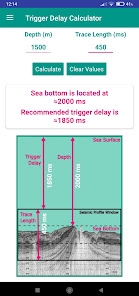
5.- Trigger Delay Calculator: This tool calculates the depth in milliseconds (time) and the recommended trigger delay to use in a seismic profile.
6.- Sea State: Wind and Waves. Now you can know the sea state using Beaufort and Douglas scales. The Beaufort scale is an empirical measure that relates wind speed to observed conditions at sea. The Douglas sea scale is a scale which measures the height of the waves.
The tools will be implemented little by little, so keep an eye out for updates as they are released.
If you have an idea for a tool that you consider helpful or would like us to add a specific tool, don't hesitate to get in touch with us at didymeapps@gmail.com. Please explain your idea in detail.
For now, the tools available on the "Ocean Tools: Marine Science" app are:
1.- Coordinates Converter: This tool permits the user to convert latitude and longitude between decimal degrees, degrees and minutes, and degrees, minutes, and seconds. Also, we have added the conversion from Decimal degree coordinates to UTM (Universal Tranverse Mercator) and from UTM coordinates to Decimal Degree. The point is shown on a map.
2. .- Multibeam Sounding density: It calculates the spatial resolution or density of soundings using a multibeam echosounder. Along-track and across-track densities depend on vessel speed, ping rate, number of beams and coverage.
Also, this app incorporates a distance calculator for a parallel multibeam echo sounder line with a user-specified overlap percentage.
3.- Shepard's Ternary Diagram: Based on the proportions of sand-, silt- and clay-sized particles, the bottom sediments are classified according to Shepard's diagram. Each sediment sample plots as a point within or along the sides of the diagram, depending on its specific grain size composition.
4. Sound velocity calculator: Calculates the velocity of sound in seawater and draws the chart. The Velocity of sound in sea-water changes with water pressure, temperature, and salinity. It is calculated by UNESCO formula.
5.- Trigger Delay Calculator: This tool calculates the depth in milliseconds (time) and the recommended trigger delay to use in a seismic profile.
6.- Sea State: Wind and Waves. Now you can know the sea state using Beaufort and Douglas scales. The Beaufort scale is an empirical measure that relates wind speed to observed conditions at sea. The Douglas sea scale is a scale which measures the height of the waves.
Updated on
Safety starts with understanding how developers collect and share your data. Data privacy and security practices may vary based on your use, region, and age. The developer provided this information and may update it over time.

No data shared with third parties
Learn more about how developers declare sharing

No data collected
Learn more about how developers declare collection
What's new
Version 1.2.3a: We have updated according to google play requirements. There are no functionality changes.
Version 1.2.3: This version incorporates a distance calculator for a parallel multibeam echo sounder line with a user-specified overlap percentage.
Version 1.2.2: Added the conversion from Decimal degree coordinates to UTM (Universal Tranverse Mercator) and from UTM coordinates to Decimal Degree.
Version 1.2.3: This version incorporates a distance calculator for a parallel multibeam echo sounder line with a user-specified overlap percentage.
Version 1.2.2: Added the conversion from Decimal degree coordinates to UTM (Universal Tranverse Mercator) and from UTM coordinates to Decimal Degree.


