
MarineTraffic - Ship Tracking
ବିଜ୍ଞାପନ ଅନ୍ତର୍ଭୂକ୍ତଆପ୍ ମଧ୍ୟରେ କ୍ରୟଗୁଡ଼ିକ
4.8star
121ହଟି ସମୀକ୍ଷା
5ନି+
ଡାଉନଲୋଡ

ସମସ୍ତେ
info


ଏହି ଆପ୍ ବିଷୟରେ
MarineTraffic displays near real-time positions of ships and yachts worldwide.
Connected to the largest network of land-based AIS receivers, the app covers most major ports and shipping routes.
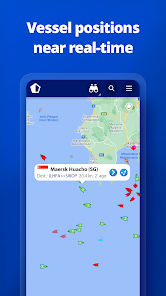
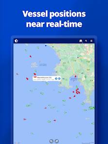
• View VESSELS ON THE LIVE MAP, search for ships, boats and seaports and see what's near you!
• More than 300,000 VESSELS PER DAY report their positions via MarineTraffic AIS
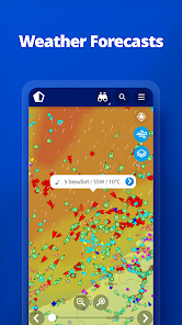
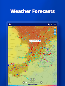
• View live wind and 48-hour WIND FORECASTS on the map
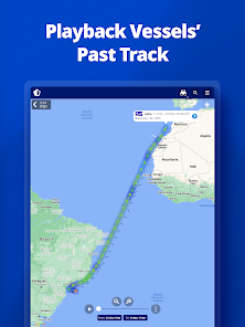
• ANIMATED PLAYBACK of vessel's track
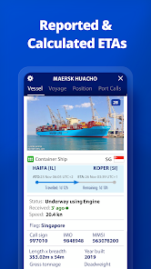
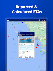
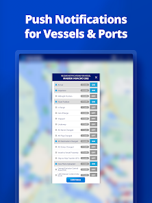
• PORT ARRIVALS & DEPARTURES live for over 4,000 ports and marinas, current conditions in ports and estimated time of arrival for the boats & ships.
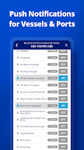
• Manage your list of vessels ("MY FLEET"), shared with all your devices and MarineTraffic.com
• Browse 4,5 MILLION PHOTOS of ships, harbours, lighthouses and much more!
• Identify and track vessels sailing beyond the range of land-based AIS receiving stations, using satellite tracking, with ACCESS PLUS 24 (in-app purchase)
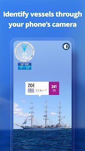
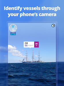
• Identify vessels around you at a glance with the Augmented Reality tool.
Just point your device's camera to the horizon and get all the information you need about the vessels in your area: name, flag, speed, distance from you and a lot more.
Also, for MarineTraffic paying subscribers:
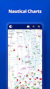
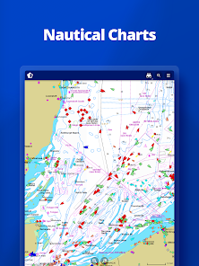
• NAUTICAL CHARTS
• ADVANCED WEATHER MAPS
• ADVANCED DENSITY MAPS
• SAT-AIS DATA
Join the great MarineTraffic community!
** If you're only interested in a specific area, please confirm coverage on www.marinetraffic.com before purchasing the app **
Connected to the largest network of land-based AIS receivers, the app covers most major ports and shipping routes.
• View VESSELS ON THE LIVE MAP, search for ships, boats and seaports and see what's near you!
• More than 300,000 VESSELS PER DAY report their positions via MarineTraffic AIS
• View live wind and 48-hour WIND FORECASTS on the map
• ANIMATED PLAYBACK of vessel's track
• PORT ARRIVALS & DEPARTURES live for over 4,000 ports and marinas, current conditions in ports and estimated time of arrival for the boats & ships.
• Manage your list of vessels ("MY FLEET"), shared with all your devices and MarineTraffic.com
• Browse 4,5 MILLION PHOTOS of ships, harbours, lighthouses and much more!
• Identify and track vessels sailing beyond the range of land-based AIS receiving stations, using satellite tracking, with ACCESS PLUS 24 (in-app purchase)
• Identify vessels around you at a glance with the Augmented Reality tool.
Just point your device's camera to the horizon and get all the information you need about the vessels in your area: name, flag, speed, distance from you and a lot more.
Also, for MarineTraffic paying subscribers:
• NAUTICAL CHARTS
• ADVANCED WEATHER MAPS
• ADVANCED DENSITY MAPS
• SAT-AIS DATA
Join the great MarineTraffic community!
** If you're only interested in a specific area, please confirm coverage on www.marinetraffic.com before purchasing the app **
ଗତ ଅପଡେଟର ସମୟ
ଡେଭେଲପରମାନେ ଆପଣଙ୍କ ଡାଟାକୁ କିପରି ସଂଗ୍ରହ ଏବଂ ସେୟାର କରନ୍ତି ସେହି ଧାରଣା ସହିତ ସୁରକ୍ଷା ଆରମ୍ଭ ହୁଏ। ଆପଣଙ୍କ ବ୍ୟବହାର, ଅଞ୍ଚଳ ଏବଂ ବୟସ ଆଧାରରେ, ଡାଟା ଗୋପନୀୟତା ଓ ସୁରକ୍ଷା ପ୍ରାକ୍ଟିସ ଭିନ୍ନ ହୋଇପାରେ। ଡେଭେଲପର ଏହି ସୂଚନା ପ୍ରଦାନ କରିଛନ୍ତି ଏବଂ ସେ ସମୟାନୁସାରେ ଏହାକୁ ଅପଡେଟ କରିପାରନ୍ତି।

ତୃତୀୟ ପକ୍ଷଗୁଡ଼ିକ ସହ କୌଣସି ଡାଟା ସେୟାର କରାଯାଇନାହିଁ
ଡେଭେଲପରମାନେ କିପରି ସେୟାରିଂର ଘୋଷଣା କରନ୍ତି ସେ ବିଷୟରେ ଅଧିକ ଜାଣନ୍ତୁ

ଏହି ଆପ ଏହି ପ୍ରକାର ଡାଟା ସଂଗ୍ରହ କରିପାରେ
ବ୍ୟକ୍ତିଗତ ସୂଚନା ଓ ଡିଭାଇସ କିମ୍ବା ଅନ୍ୟ ID

ଟ୍ରାଞ୍ଜିଟ ସମୟରେ ଡାଟା ଏନକ୍ରିପ୍ଟ କରାଯାଇଥାଏ

ଡାଟା ଡିଲିଟ କରିଦିଆଯାଉ ବୋଲି ଆପଣ ଅନୁରୋଧ କରିପାରିବେ
ମୂଲ୍ୟାଙ୍କନ ଓ ସମୀକ୍ଷା
4.8
114ହଟି ସମୀକ୍ଷା
ନୂଆ କଣ ଅଛି
- Fixes issue with Augmented Reality
- Other fixes and improvements
- Other fixes and improvements
ଆପ ସପୋର୍ଟ
ଡେଭେଲପରଙ୍କ ବିଷୟରେ
MARINETRAFFIC APPLICATIONS LTD
mobileapp@marinetraffic.com
73 Metochiou
Egkomi Nicosias 2407
Cyprus
+30 21 1199 6217


