

Gisella - Field GIS
Kupovina unutar aplikacije

10 hilj.+
Preuzimanja

Svako
info


O aplikaciji
Gisella is a mobile GIS application that allows you to create and manage all geographic objects directly on your mobile device. Examples, instructions, and support are available at support.gisella.app
The Geographic Information System offers you everything from map object management to layers to entire map projects.
Our GIS application supports common data formats as KML, GeoJSON and ESRI Shapefile worldwide. Gisella excels in collaboration with QGIS desktop software, ArcGIS or web systems such as WEGAS, Google My Maps and many others. Data import and export takes place directly to your device or via Google Drive.
Main GIS Features:
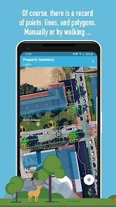
▪ Point, line, polygon geometry (up to 50 elements per layer in Free version)
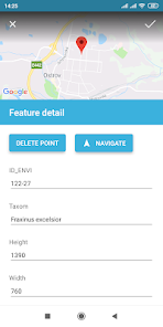
▪ Attributes of string, number, or enumerated data type
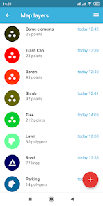
▪ Layer Styles - color, point icon, line width, polygon transparency, and more
▪ Creating map projects from layers (the layer can be part of multiple projects)
▪ Creating new map layers and editing existing (even imported ones)
▪ Creating and editing vertexes (points) via GPS device or manually over the map background
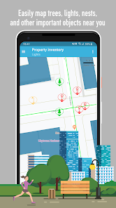
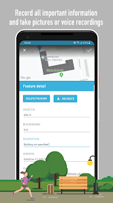
▪ Data collection and the ability to insert photos to individual geometries (point, line, area)
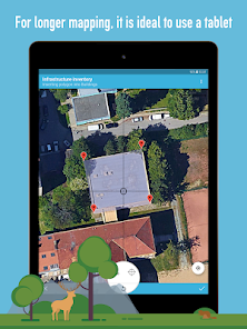
▪ Worldwide mapping via Google API - topographic, hybrid (an option of working offline after loading underlying maps)
▪ Import and export of layers in KML, GeoJSON and ESRI Shapefile formats (with or without multimedia) to your device or Google Drive (in Free version export to KML)
▪ Export and import of the entire database for backup or sharing among users (available only in Pro version)
And that is not everything yet!
Gisella Geographic Information System is one of the few GIS applications that allows you to create and manage all objects directly on your mobile device. You can insert and edit many things from map objects to layers to entire map projects. In addition, combining accurate and up-to-date data will reduce error rates, support your decisions with real data, and reduce property management costs.
Are you worried that it is too difficult for you?
Don't worry, we are here even for beginners. You can easily process the collected data from Gisella in Google My Maps. Take an advantage of exporting to KML and sharing to Google Drive.
Since the application was developed in the Czech Republic, you can download Gisella either in English or Czech language therefore it is suitable for wide range of users.
You still have collected and edited data in your hands (on your device or your Google account). We do not collect or analyze them anywhere.
The Geographic Information System offers you everything from map object management to layers to entire map projects.
Our GIS application supports common data formats as KML, GeoJSON and ESRI Shapefile worldwide. Gisella excels in collaboration with QGIS desktop software, ArcGIS or web systems such as WEGAS, Google My Maps and many others. Data import and export takes place directly to your device or via Google Drive.
Main GIS Features:
▪ Point, line, polygon geometry (up to 50 elements per layer in Free version)
▪ Attributes of string, number, or enumerated data type
▪ Layer Styles - color, point icon, line width, polygon transparency, and more
▪ Creating map projects from layers (the layer can be part of multiple projects)
▪ Creating new map layers and editing existing (even imported ones)
▪ Creating and editing vertexes (points) via GPS device or manually over the map background
▪ Data collection and the ability to insert photos to individual geometries (point, line, area)
▪ Worldwide mapping via Google API - topographic, hybrid (an option of working offline after loading underlying maps)
▪ Import and export of layers in KML, GeoJSON and ESRI Shapefile formats (with or without multimedia) to your device or Google Drive (in Free version export to KML)
▪ Export and import of the entire database for backup or sharing among users (available only in Pro version)
And that is not everything yet!
Gisella Geographic Information System is one of the few GIS applications that allows you to create and manage all objects directly on your mobile device. You can insert and edit many things from map objects to layers to entire map projects. In addition, combining accurate and up-to-date data will reduce error rates, support your decisions with real data, and reduce property management costs.
Are you worried that it is too difficult for you?
Don't worry, we are here even for beginners. You can easily process the collected data from Gisella in Google My Maps. Take an advantage of exporting to KML and sharing to Google Drive.
Since the application was developed in the Czech Republic, you can download Gisella either in English or Czech language therefore it is suitable for wide range of users.
You still have collected and edited data in your hands (on your device or your Google account). We do not collect or analyze them anywhere.
Ažurirano dana
Sigurnost počinje razumijevanjem na koji način programeri prikupljaju i dijele vaše podatke. Privatnost podataka i sigurnosne prakse se mogu razlikovati ovisno o korištenju, regiji i dobi. Programer je naveo ove informacije i može ih s vremenom ažurirati.

Podaci se ne dijele s trećim stranama
Saznajte više o načinu na koji programeri pružaju izjavu o dijeljenju

Ova aplikacija može prikupljati ove vrste podataka
Aktivnost aplikacija i Informacije o aplikacijama i performanse

Podaci se šifriraju tokom prenosa
Što je novo
Improved application stability and bug fixes.
Podrška za aplikaciju
Informacije o programeru
ENVIPARTNER, s.r.o.
vybral@envipartner.cz
546/55 Vídeňská
639 00 Brno
Czechia
+420 797 979 549


